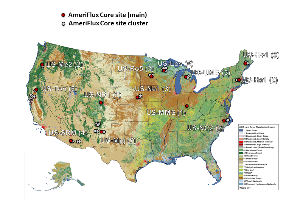
What are the AmeriFlux Core Sites?

AmeriFlux Core Sites are flux towers whose managing PIs and staff have agreed to deliver timely, high quality, continuous data to the AmeriFlux database. They receive operations and instrumentation support from the AmeriFlux Management Project (AMP). A primary goal for AMP is to ensure high quality data collection from these sites, which represent a broad range of ecosystems and locations in the continental United States. AMP receives funding support for the AmeriFlux core sites from Department of Energy, Office of Science, Terrestrial Ecosystem Science Program.
Currently 43 AMP-supported core sites exist, in 11 clusters, and 2 individual sites. Two more sites (US-MOz and US-ARM) have voluntarily agreed to the same data quality and delivery standards as the AMP-supported core sites, but do not receive AMP funding. The original sites were selected after careful review in 2012-2013, based on ecosystem representation, length of prior data record, quality of existing data, and established ability of site PIs to provide continuity in site management.
In our blog series Note from the Flux Site, Core site staff offer their own perspectives into various challenges and scientific questions that arise at their site.
Note: A Core Site Cluster is a case where support for one primary core site has been leveraged to support several sites. For example, support for a data manager assures timely data review and processing for several sites.
Current Core Sites with Contacts
*Signifies this is the “primary” site for that core site cluster.
Harvard Forest
- US-Ha1* • Harvard Forest EMS Tower (HFR1): deciduous broadleaf forest
- US-Ha2 • Harvard Forest Hemlock Site: evergreen needleleaf forest: primarily hemlock
Bill Munger, Harvard University, jwmunger@seas.harvard.edu
Morgan Monroe State Forest (MMSF)
- US-MMS* • Morgan Monroe State Forest: deciduous broadleaf forest
Kim Novick, Indiana University, knovick@indiana.edu
Rich Phillips, rpp6@indiana.edu
Note: US-BRG • Morgan Monroe State Forest retired late 2021.
ChEAS (Chequamegon Ecosystem-Atmosphere Study)
- US-Los* • Lost Creek: shrubby wetland (longest running wetland flux site in US)
- US-Syv • Sylvania Wilderness Area: old-growth (350 y) mature northern hardwood forest
- US-PFa • Park Falls/WLEF (very tall tower): shrub/forest wetland, mixed conifer/hardwood (50 y)
- US-WCr • Willow Creek (mature hardwood): mature northern hardwood forest
- US-ALQ • Allequasch Creek: permanent wetland
Ankur Desai, University of Wisconsin, desai@aos.wisc.edu
Ken Davis, Pennsylvania State University, kjd10@psu.edu
New Mexico Elevation Gradient (NMEG)
- US-Mpj* • Pinon-juniper site (Mountainair): pinyon-juniper forest 2100 m
- US-Wjs • Juniper savanna site (Willard): open shrubland, 1925 m
- US-Vcp • Valles Caldera National Preserve: evergreen needleleaf forest (Ponderosa pine), 2542 m
- US-Vcm • Valles Caldera National Preserve: evergreen needleleaf (mixed conifer), 3000 m; wildfire in 2012
- US-Ses • Sevilleta (LTER desert shrubland): open shrubland, 1593 m
- US-Seg • Sevilleta (LTER desert grassland): desert grassland, 1622m
- US-Vcs • Subalpine mixed conifer: evergreen needleleaf forest, 2752 m
Marcy Litvak, University of New Mexico, mlitvak@unm.edu
Santa Rita/Walnut Gulch
- US-SRM* • Santa Rita Mesquite: semi-desert grassland
- US-Wkg • Walnut Gulch Kendall Grasslands: desert grassland, grazing
- US-Whs • Walnut Gulch Lucky Hills Shrub: Chihuahuan Desert shrubland
- US-SRG • Santa Rita Grassland: semi-desert grassland
Russell Scott, USDA-ARS Western Area, Russ.Scott@ars.usda.gov
Tonzi/Vaira/Delta
- US-Ton* • Tonzi Ranch: Sierra Foothills—oak savanna, grazed
- US-Var • Vaira Ranch • Ione: Sierra Foothills—oak savanna, grazed
- US-Myb • Mayberry Wetland: Sacramento Delta—wetland restored 2010
- US-Bi1 • Bouldin Island Alfalfa: croplands
- US-Bi2 • Bouldin Island Corn: cropland
Former sites in this cluster:
- US-Snd—Sherman Island. Retired 2015 as the land was converted into a restored wetland.
- US-Twt—Twitchell Island. Sacramento Delta—rice paddy. Retired 2017.
- US-Tw3—Twitchell Alfalfa. Retired 2018.
- US-Tw1 • Twitchell Island (wet west): Sacramento Delta—wetland restored 1997. Retired 2023.
- US-Tw4—Twitchell East End Wetland. Removed from Core site cluster in 2020 (still operational as of 4/2023).
- US-Sne—Sherman Island Restored Wetland. Removed from Core site cluster in 2020 (still operational as of 4/2023).
Dennis Baldocchi, UC Berkeley, baldocchi@berkeley.edu
North Carolina Loblolly Pine
- US-NC2* • NC Loblolly Plantation: SE Loblolly Pine, managed
- US-NC4 • Alligator River National Wildlife Refuge: coastal forested wetlands experiencing rising water level
Note: US-NC3—NC Loblolly: SE Loblolly Pine, managed. Retired late 2021, due to vegetation outgrowing infrastructure.
Asko Noormets, Texas A&M, noormets@tamu.edu
John King, North Carolina State University, john_king@ncsu.edu
Niwot Ridge
- US-NR1* • Niwot Ridge Forest (LTER NWT1): subalpine conifer forest
Peter Blanken, University of Colorado, blanken@colorado.edu
University of Michigan Biological Station (UMBS)
- US-UMB* • University of Michigan Biological Station: deciduous broadleaf forest
- US-UMd* • UMBS Disturbance: deciduous broadleaf forest, succession experiment
- US-OWC • Old Woman Creek: natural freshwater estuary
- US-RRC • Rice Rivers Center Marsh: restored freshwater, tidal wetland
Gil Bohrer, Ohio State University, bohrer.17@osu.edu
Christopher Gough, Virginia Commonwealth University, cmgough@vcu.edu
Rosemount
- US-Ro5* • Rosemount: corn/soybean rotation. Replaces Ro1. See Note.
- US-Ro4 • Rosemount: restored prairie. New late 2015. Replaces Ro3. See Note.
- US-Ro6 • Rosemount: corn/soybean/winter cover rotation with minimal tillage. Replaces Ro2. See Note.
Note: Ro1-conventional corn/soybean rotation (no longer active). The system was moved to a new field in 2017 (US-Ro5).
Note: Ro2-Alternative agricultural site (no longer active). The system was moved to a new field (US-Ro6).
Note: Ro3—corn/soybean in permanent kura clover. Retired late 2015. (US-Ro4)
Tim Griffis, University of Minnesota, tgriffis@umn.edu
Howland Forest
- US-Ho1* • Howland Forest (main tower): since 1996
- US-Ho2 • Howland Forest (west tower): since 1999
- US-Ho3 • Howland Forest (harvest site): since 2003
Andrew Ouimette, USDA Forest Service Northern Area, Andrew.Ouimette@usda.gov
Metolius Pine
- US-Me2* • Metolius-intermediate aged Ponderosa pine: evergreen needleleaf forest, 64 y
- US-Me6 • Metolius young pine burn: evergreen needleleaf forest, 20 y, post-fire
- US-Me4 • Metolius-old aged ponderosa pine (site reestablished in 2024)
Chad Hanson, Oregon State University, chad.hanson@oregonstate.edu
Mead
- US-Ne1* • Irrigated continuous maize
- US-Ne2 • Irrigated maize/soybean, no-till
- US-Ne3 • Rainfall maize/soybean, no-till
Andrew Suyker, University of Nebraska-Lincoln, asuyker@unl.edu
Former Core site cluster: Konza (Core site cluster from 2014-2020)
- US-Kon • Konza Prairie LTER
- US-KFS • Kansas Field Station
- US-KFB • Konza Prairie LTER
- US-KLS • Kansas Land Institute
Nate Brunsell, Kansas State University

