
US-NC4: NC_AlligatorRiver
- Overview
- Windroses
- Data Citation
- Data Use Log
- Image Gallery
- Remote Sensing Data
- MODIS
- PhenoCam
- GeoNEX
- Publications
- BADM
| Tower_team: | |
| Technician: | Miko Lorenzo Belgado mjbelgad@ncsu.edu - North Carolina State University |
| PI: | Asko Noormets noormets@tamu.edu - Texas A&M University |
| PI: | John King john_king@ncsu.edu - North Carolina State University |
| DataManager: | Benju Baniya benju.baniya@ag.tamu.edu - Texas A&M University |
| DataManager: | Jiaojiao Dong jiaodong@tamu.edu - Texas A&M University |
| Lat, Long: | 35.7879, -75.9038 |
| Elevation(m): | 1 |
| Network Affiliations: | AmeriFlux, Phenocam |
| Vegetation IGBP: | WET (Permanent Wetlands: Lands with a permanent mixture of water and herbaceous or woody vegetation that cover extensive areas. The vegetation can be present in either salt, brackish, or fresh water) |
| Climate Koeppen: | Cfa (Humid Subtropical: mild with no dry season, hot summer) |
| Mean Annual Temp (°C): | 16.6 |
| Mean Annual Precip. (mm): | 1311 |
| Flux Species Measured: | CO2, CH4 |
| Years Data Collected: | 2009 - Present |
| Years Data Available: | AmeriFlux BASE 2009 - 2025 Data Citation AmeriFlux FLUXNET 2009 - 2025 Data Citation |
| Data Use Policy: | AmeriFlux CC-BY-4.0 Policy1 |
| Description: | |
| URL: | https://sites.google.com/site/ncfluxcoresites/ |
| Research Topics: | Hydrological regulation of CO2 and CH4 exchange, dynamics of soil carbon, partitioning of respiration |
| Acknowledgment: | — |
- This site’s data can also be used under the more restrictive AmeriFlux Legacy Policy.
The AmeriFlux Legacy Policy must be followed if this site’s data are combined with data from sites that require the AmeriFlux Legacy Policy.
Copyright preference: Open use
US-NC4: NC_AlligatorRiver
- Overview
- Windroses
- Data Citation
- Data Use Log
- Image Gallery
- Remote Sensing Data
- MODIS
- PhenoCam
- GeoNEX
- Publications
- BADM
Use the information below for citation of this site. See the Data Policy page for more details.
DOI(s) for citing US-NC4 data
Data Use Policy: AmeriFlux CC-BY-4.0 License
This site’s data can also be used under the more restrictive AmeriFlux Legacy Policy.
The AmeriFlux Legacy Policy must be followed if US-NC4 data are combined with data from sites that require the AmeriFlux Legacy Policy.
- AmeriFlux BASE: https://doi.org/10.17190/AMF/1480314
Citation: Asko Noormets, John King, Bhaskar Mitra, Guofang Miao, Maricar Aguilos, Kevan Minick, Prajaya Prajapati, Jean-Christophe Domec, Benju Baniya, Jiaojiao Dong, Miko Lorenzo Belgado (2026), AmeriFlux BASE US-NC4 NC_AlligatorRiver, Ver. 11-5, AmeriFlux AMP, (Dataset). https://doi.org/10.17190/AMF/1480314 - AmeriFlux FLUXNET: https://doi.org/10.17190/AMF/1902837
Citation: Asko Noormets, John King, Bhaskar Mitra, Guofang Miao, Maricar Aguilos, Kevan Minick, Prajaya Prajapati, Jean-Christophe Domec, Benju Baniya, Jiaojiao Dong, Miko Lorenzo Belgado (2026), AmeriFlux FLUXNET-1F US-NC4 NC_AlligatorRiver, Ver. v1.3_r1, AmeriFlux AMP, (Dataset). https://doi.org/10.17190/AMF/1902837
Find global FLUXNET datasets, like FLUXNET2015 and FLUXNET-CH4, and their citation information at fluxnet.org.
To cite BADM when downloaded on their own, use the publications below for citing site characterization. When using BADM that are downloaded with AmeriFlux BASE and AmeriFlux FLUXNET products, use the DOI citation for the associated data product.
Publication(s) for citing site characterization
- —
Acknowledgments
- —
Resources
- AmeriFlux Logos & Acknowledgments
US-NC4: NC_AlligatorRiver
- Overview
- Windroses
- Data Citation
- Data Use Log
- Image Gallery
- Remote Sensing Data
- MODIS
- PhenoCam
- GeoNEX
- Publications
- BADM

This page displays the list of downloads of data for the site {{siteId}}.
Note: Results are the number of downloads to distinct data users. The Download Count column indicates the number of times the data user downloaded the data. The Version column refers to the version of the data product for the site that was downloaded by the data user.
| Date | Name | Data Product | Vers. | Intended Use | Intended Use Description | Download Count |
|---|---|---|---|---|---|---|
| {{dlObject.timeStamp}} | {{dlObject.displayName}} | {{displayProduct(dlObject.dataProduct)}} | {{dlObject.version}} | {{dlObject.intendedUse}} | {{dlObject.comment}} | {{dlObject.downloadCounter}} |
Showing {{startItem + 1}} to {{(startItem + items) > filtered.length ? filtered.length : (startItem + items)}} of {{filtered.length}} results
Showing 0 to 0 of 0 results
Not Found
Uh Oh. Something is missing. Try double checking the URL and try again.
US-NC4: NC_AlligatorRiver
- Overview
- Windroses
- Data Citation
- Data Use Log
- Image Gallery
- Remote Sensing Data
- MODIS
- PhenoCam
- GeoNEX
- Publications
- BADM
| AmeriFlux Images | Add Image |
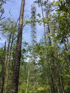
US-NC4 US-NC4 Flux Tower
Keywords: —
Location: United States
View in Original Size
To download, right-click photo (Mac: control-click) and choose Save Image As
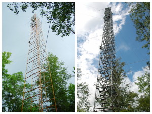 US-NC4
 Evolution of US-NC4 tower
Keywords: —
Location: North Carolina, United States
View in Original Size
To download, right-click photo (Mac: control-click) and choose Save Image As
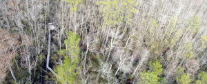 US-NC4
 Canopy, boardwalk and ground met station at US-NC4
Keywords: —
Location: North Carolina, United States
View in Original Size
To download, right-click photo (Mac: control-click) and choose Save Image As
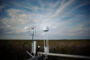 US-NC4
 Equipment on US-NC4 tower
Keywords: —
Location: North Carolina, United States
View in Original Size
To download, right-click photo (Mac: control-click) and choose Save Image As
US-NC4: NC_AlligatorRiver
- Overview
- Windroses
- Data Citation
- Data Use Log
- Image Gallery
- Remote Sensing Data
- MODIS
- PhenoCam
- GeoNEX
- Publications
- BADM
MODIS NDVI
The time series shows the 16-day Normalized Difference Vegetation Index (NDVI) average from the MOD13Q1 data product.
Use the slider below the time series to zoom in and out.
To view / download these data and other MOD13Q1 products for this site, visit MODIS/Terra Vegetation Indices.
For other related products, visit MODIS/VIIRS Fixed Sites Subsets Tool.
Citation:
ORNL DAAC. 2018. Terrestrial Ecology Subsetting & Visualization Services (TESViS) Fixed Sites Subsets. ORNL DAAC, Oak Ridge, Tennessee, USA. https://doi.org/10.3334/ORNLDAAC/1567
MODIS NDVI subsetted data is not yet available for this site.
For a complete list of AmeriFlux sites, visit ORNL DAAC's MODIS/VIIRS Fixed Sites Subsets Tool.


US-NC4: NC_AlligatorRiver
- Overview
- Windroses
- Data Citation
- Data Use Log
- Image Gallery
- Remote Sensing Data
- MODIS
- PhenoCam
- GeoNEX
- Publications
- BADM
| AmeriFlux Publications | Add Publication |
| Year | Publication |
|---|---|
| 2024 | Aguilos, M., Carter, C., Middlebrough, B., Bulluck, J., Webb, J., Brannum, K., Watts, J. O., Lobeira, M., Sun, G., McNulty, S., King, J. (2024) Hydrologic Perturbation Is A Key Driver Of Tree Mortality In Bottomland Hardwood Wetland Forests Of North Carolina, Usa, Forests, 16(1), 39. https://doi.org/https://doi.org/10.3390/f16010039 |
| 2025 | He, K., Li, W., Zhang, Y., Zeng, A., de Graaf, I. E., Aguilos, M., Sun, G., McNulty, S. G., King, J. S., Flanagan, N. E., Richardson, C. J. (2025) Temperature And Water Levels Collectively Regulate Methane Emissions From Subtropical Freshwater Wetlands, Global Biogeochemical Cycles, 39(3), . https://doi.org/https://doi.org/10.1029/2024GB008372 |
| 2023 | Wells, J. M., Aguilos, M., Huang, X., Gao, Y., Hou, E., Huang, W., Liao, C., Lin, L., Zhao, R., Qiu, H., Allen, K., King, J., Noormets, A., Jiang, L., Luo, Y. (2023) Attributing Interannual Variability Of Net Ecosystem Exchange To Modeled Ecological Processes In Forested Wetlands Of Contrasting Stand Age, Landscape Ecology, 38(12), 3985-3998. https://doi.org/https://doi.org/10.1007/s10980-023-01768-x |
| 2021 | Minick, K. J., Mitra, B., Li, X., Fischer, M., Aguilos, M., Prajapati, P., Noormets, A., King, J. S. (2021) Wetland Microtopography Alters Response Of Potential Net Co2 And Ch4 Production To Temperature And Moisture: Evidence From A Laboratory Experiment, Geoderma, 402, 115367. https://doi.org/10.1016/j.geoderma.2021.115367 |
| 2022 | Minick, K. J., Aguilos, M., Li, X., Mitra, B., Prajapati, P., King, J. S. (2022) Effects Of Spatial Variability And Drainage On Extracellular Enzyme Activity In Coastal Freshwater Forested Wetlands Of Eastern North Carolina, Usa, Forests, 13(6), 861. https://doi.org/10.3390/f13060861 |
| 2020 | Aguilos, M., Mitra, B., Noormets, A., Minick, K., Prajapati, P., Gavazzi, M., Sun, G., McNulty, S., Li, X., Domec, J., Miao, G., King, J. (2020) Long-Term Carbon Flux And Balance In Managed And Natural Coastal Forested Wetlands Of The Southeastern Usa, Agricultural And Forest Meteorology, 288-289, 108022. https://doi.org/10.1016/j.agrformet.2020.108022 |
| 2021 | Aguilos, M., Sun, G., Noormets, A., Domec, J., McNulty, S., Gavazzi, M., Minick, K., Mitra, B., Prajapati, P., Yang, Y., King, J. (2021) Effects Of Land-Use Change And Drought On Decadal Evapotranspiration And Water Balance Of Natural And Managed Forested Wetlands Along The Southeastern Us Lower Coastal Plain, Agricultural And Forest Meteorology, 303, 108381. https://doi.org/10.1016/j.agrformet.2021.108381 |
| 2022 | Aguilos, M., Warr, I., Irving, M., Gregg, O., Grady, S., Peele, T., Noormets, A., Sun, G., Liu, N., McNulty, S., Pettay, F., Bhattacharya, S., Penney, S., Kerrigan, M., Yang, L., Mitra, B., Prajapati, P., Minick, K., King, J. (2022) The Unabated Atmospheric Carbon Losses In A Drowning Wetland Forest Of North Carolina: A Point Of No Return?, Forests, 13(8), 1264. https://doi.org/10.3390/f13081264 |
| 2021 | Chu, H., Luo, X., Ouyang, Z., Chan, W. S., Dengel, S., Biraud, S. C., Torn, M. S., Metzger, S., Kumar, J., Arain, M. A., Arkebauer, T. J., Baldocchi, D., Bernacchi, C., Billesbach, D., Black, T. A., Blanken, P. D., Bohrer, G., Bracho, R., Brown, S., Brunsell, N. A., Chen, J., Chen, X., Clark, K., Desai, A. R., Duman, T., Durden, D., Fares, S., Forbrich, I., Gamon, J. A., Gough, C. M., Griffis, T., Helbig, M., Hollinger, D., Humphreys, E., Ikawa, H., Iwata, H., Ju, Y., Knowles, J. F., Knox, S. H., Kobayashi, H., Kolb, T., Law, B., Lee, X., Litvak, M., Liu, H., Munger, J. W., Noormets, A., Novick, K., Oberbauer, S. F., Oechel, W., Oikawa, P., Papuga, S. A., Pendall, E., Prajapati, P., Prueger, J., Quinton, W. L., Richardson, A. D., Russell, E. S., Scott, R. L., Starr, G., Staebler, R., Stoy, P. C., Stuart-Haëntjens, E., Sonnentag, O., Sullivan, R. C., Suyker, A., Ueyama, M., Vargas, R., Wood, J. D., Zona, D. (2021) Representativeness Of Eddy-Covariance Flux Footprints For Areas Surrounding Ameriflux Sites, Agricultural And Forest Meteorology, 301-302, 108350. https://doi.org/10.1016/j.agrformet.2021.108350 |
| 2017 | Miao, G., Noormets, A., Domec, J., Fuentes, M., Trettin, C. C., Sun, G., McNulty, S. G., King, J. S. (2017) Hydrology And Microtopography Control Carbon Dynamics In Wetlands: Implications In Partitioning Ecosystem Respiration In A Coastal Plain Forested Wetland, Agricultural And Forest Meteorology, 247, 343-355. https://doi.org/10.1016/j.agrformet.2017.08.022 |
| 2020 | Feagin, R. A., Forbrich, I., Huff, T. P., Barr, J. G., Ruiz‐Plancarte, J., Fuentes, J. D., Najjar, R. G., Vargas, R., Vázquez‐Lule, A., Windham‐Myers, L., Kroeger, K. D., Ward, E. J., Moore, G. W., Leclerc, M., Krauss, K. W., Stagg, C. L., Alber, M., Knox, S. H., Schäfer, K. V., Bianchi, T. S., Hutchings, J. A., Nahrawi, H., Noormets, A., Mitra, B., Jaimes, A., Hinson, A. L., Bergamaschi, B., King, J. S., Miao, G. (2020) Tidal Wetland Gross Primary Production Across The Continental United States, 2000–2019, Global Biogeochemical Cycles, 34(2), . https://doi.org/10.1029/2019GB006349 |
| 2018 | Minick, K., Kelley, A., Miao, G., Li, X., Noormets, A., Mitra, B., King, J.S. (2018) Microtopography Alters Hydrology, Phenol Oxidase Activity and Nutrient Availability in Organic Soils of a Coastal Freshwater Forested Wetland, Wetlands, 1-11. https://doi.org/10.1007 |
| 2013 | Miao, G., Noormets, A., Domec, J., Trettin, C. C., McNulty, S. G., Sun, G., King, J. S. (2013) The Effect Of Water Table Fluctuation On Soil Respiration In A Lower Coastal Plain Forested Wetland In The Southeastern U.S., Journal Of Geophysical Research: Biogeosciences, 118(4), 1748-1762. https://doi.org/10.1002/2013JG002354 |
US-NC4: NC_AlligatorRiver
- Overview
- Windroses
- Data Citation
- Data Use Log
- Image Gallery
- Remote Sensing Data
- MODIS
- PhenoCam
- GeoNEX
- Publications
- BADM
BADM for This Site
Access the Biological, Ancillary, Disturbance and Metadata (BADM) information and data for this site.
BADM contain information for many uses, such as characterizing a site’s vegetation and soil, describing disturbance history, and defining instrumentation for flux processing. They complement the flux/met data.
- Download BADM for this site*
- View Site General Info for this site (Overview tab)*
- Use Online Editor to update Site General Info or DOI Authorship
- Update information about submitted data (Variable Information tool)
- More BADM resources
* Online updates are shown on the Overview tab real time. However, downloaded BADM files will not reflect those updates until they have been reviewed for QA/QC.
US-NC4: NC_AlligatorRiver
- Overview
- Windroses
- Data Citation
- Data Use Log
- Image Gallery
- Remote Sensing Data
- MODIS
- PhenoCam
- GeoNEX
- Publications
- BADM
Wind Roses
Wind Speed (m/s)
- Wind Speed Scale: Per Site
- Wind Direction Scale (%): Per Site
- Wind Speed Scale: Non-Linear
- Wind Direction Scale (%): AmeriFlux