
US-Whs: Walnut Gulch Lucky Hills Shrub
- Overview
- Windroses
- Data Citation
- Data Use Log
- Image Gallery
- Remote Sensing Data
- MODIS
- PhenoCam
- GeoNEX
- Publications
- BADM
| Tower_team: | |
| PI: | Russell Scott russ.scott@ars.usda.gov - United States Department of Agriculture |
| Technician: | Ross Bryant Ross.Bryant@ars.usda.gov - USDA-ARS-SWRC |
| Lat, Long: | 31.7438, -110.0522 |
| Elevation(m): | 1370 |
| Network Affiliations: | AmeriFlux, LTAR, Phenocam |
| Vegetation IGBP: | OSH (Open Shrublands: Lands with woody vegetation less than 2 meters tall and with shrub canopy cover between 10-60%. The shrub foliage can be either evergreen or deciduous.) |
| Climate Koeppen: | Bsk (Steppe: warm winter) |
| Mean Annual Temp (°C): | 17.6 |
| Mean Annual Precip. (mm): | 320 |
| Flux Species Measured: | CO2, H2O |
| Years Data Collected: | 2007 - Present |
| Years Data Available: | AmeriFlux BASE 2007 - 2025 Data Citation AmeriFlux FLUXNET 2007 - 2025 Data Citation |
| Data Use Policy: | AmeriFlux CC-BY-4.0 Policy1 |
| Description: | |
| URL: | https://www.ars.usda.gov/pacific-west-area/tucson-az/southwest-watershed-research |
| Research Topics: | Desert shrubland carbon and water cycling, ET partitioning, soil respiration |
| Acknowledgment: | — |
- This site’s data can also be used under the more restrictive AmeriFlux Legacy Policy.
The AmeriFlux Legacy Policy must be followed if this site’s data are combined with data from sites that require the AmeriFlux Legacy Policy.
Copyright preference: As long as credit is given
US-Whs: Walnut Gulch Lucky Hills Shrub
- Overview
- Windroses
- Data Citation
- Data Use Log
- Image Gallery
- Remote Sensing Data
- MODIS
- PhenoCam
- GeoNEX
- Publications
- BADM
Use the information below for citation of this site. See the Data Policy page for more details.
DOI(s) for citing US-Whs data
Data Use Policy: AmeriFlux CC-BY-4.0 License
This site’s data can also be used under the more restrictive AmeriFlux Legacy Policy.
The AmeriFlux Legacy Policy must be followed if US-Whs data are combined with data from sites that require the AmeriFlux Legacy Policy.
- AmeriFlux BASE: https://doi.org/10.17190/AMF/1246113
Citation: Russ Scott (2026), AmeriFlux BASE US-Whs Walnut Gulch Lucky Hills Shrub, Ver. 27-5, AmeriFlux AMP, (Dataset). https://doi.org/10.17190/AMF/1246113 - AmeriFlux FLUXNET: https://doi.org/10.17190/AMF/1984574
Citation: Russ Scott (2026), AmeriFlux FLUXNET-1F US-Whs Walnut Gulch Lucky Hills Shrub, Ver. v1.3_r1, AmeriFlux AMP, (Dataset). https://doi.org/10.17190/AMF/1984574
Find global FLUXNET datasets, like FLUXNET2015 and FLUXNET-CH4, and their citation information at fluxnet.org.
To cite BADM when downloaded on their own, use the publications below for citing site characterization. When using BADM that are downloaded with AmeriFlux BASE and AmeriFlux FLUXNET products, use the DOI citation for the associated data product.
Publication(s) for citing site characterization
- —
Acknowledgments
- —
Resources
- AmeriFlux Logos & Acknowledgments
US-Whs: Walnut Gulch Lucky Hills Shrub
- Overview
- Windroses
- Data Citation
- Data Use Log
- Image Gallery
- Remote Sensing Data
- MODIS
- PhenoCam
- GeoNEX
- Publications
- BADM

This page displays the list of downloads of data for the site {{siteId}}.
Note: Results are the number of downloads to distinct data users. The Download Count column indicates the number of times the data user downloaded the data. The Version column refers to the version of the data product for the site that was downloaded by the data user.
| Date | Name | Data Product | Vers. | Intended Use | Intended Use Description | Download Count |
|---|---|---|---|---|---|---|
| {{dlObject.timeStamp}} | {{dlObject.displayName}} | {{displayProduct(dlObject.dataProduct)}} | {{dlObject.version}} | {{dlObject.intendedUse}} | {{dlObject.comment}} | {{dlObject.downloadCounter}} |
Showing {{startItem + 1}} to {{(startItem + items) > filtered.length ? filtered.length : (startItem + items)}} of {{filtered.length}} results
Showing 0 to 0 of 0 results
Not Found
Uh Oh. Something is missing. Try double checking the URL and try again.
US-Whs: Walnut Gulch Lucky Hills Shrub
- Overview
- Windroses
- Data Citation
- Data Use Log
- Image Gallery
- Remote Sensing Data
- MODIS
- PhenoCam
- GeoNEX
- Publications
- BADM
| AmeriFlux Images | Add Image |
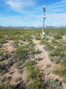
US-Whs Lucky Hills Shrubland Ameriflux Site
Keywords: —
Location: Arizona, United States
View in Original Size
To download, right-click photo (Mac: control-click) and choose Save Image As
US-Whs: Walnut Gulch Lucky Hills Shrub
- Overview
- Windroses
- Data Citation
- Data Use Log
- Image Gallery
- Remote Sensing Data
- MODIS
- PhenoCam
- GeoNEX
- Publications
- BADM
MODIS NDVI
The time series shows the 16-day Normalized Difference Vegetation Index (NDVI) average from the MOD13Q1 data product.
Use the slider below the time series to zoom in and out.
To view / download these data and other MOD13Q1 products for this site, visit MODIS/Terra Vegetation Indices.
For other related products, visit MODIS/VIIRS Fixed Sites Subsets Tool.
Citation:
ORNL DAAC. 2018. Terrestrial Ecology Subsetting & Visualization Services (TESViS) Fixed Sites Subsets. ORNL DAAC, Oak Ridge, Tennessee, USA. https://doi.org/10.3334/ORNLDAAC/1567
MODIS NDVI subsetted data is not yet available for this site.
For a complete list of AmeriFlux sites, visit ORNL DAAC's MODIS/VIIRS Fixed Sites Subsets Tool.


US-Whs: Walnut Gulch Lucky Hills Shrub
- Overview
- Windroses
- Data Citation
- Data Use Log
- Image Gallery
- Remote Sensing Data
- MODIS
- PhenoCam
- GeoNEX
- Publications
- BADM
| AmeriFlux Publications | Add Publication |
| Year | Publication |
|---|---|
| 2020 | Hu, P., Tang, J., Fan, J., Shu, S., Hu, Z., Zhu, B. (2020) Incorporating A Rainfall Intensity Modification Factor γ Into The IA-, International Soil And Water Conservation Research, 8(3), 237-244. https://doi.org/10.1016/j.iswcr.2020.07.004 |
| 2021 | Chu, H., Luo, X., Ouyang, Z., Chan, W. S., Dengel, S., Biraud, S. C., Torn, M. S., Metzger, S., Kumar, J., Arain, M. A., Arkebauer, T. J., Baldocchi, D., Bernacchi, C., Billesbach, D., Black, T. A., Blanken, P. D., Bohrer, G., Bracho, R., Brown, S., Brunsell, N. A., Chen, J., Chen, X., Clark, K., Desai, A. R., Duman, T., Durden, D., Fares, S., Forbrich, I., Gamon, J. A., Gough, C. M., Griffis, T., Helbig, M., Hollinger, D., Humphreys, E., Ikawa, H., Iwata, H., Ju, Y., Knowles, J. F., Knox, S. H., Kobayashi, H., Kolb, T., Law, B., Lee, X., Litvak, M., Liu, H., Munger, J. W., Noormets, A., Novick, K., Oberbauer, S. F., Oechel, W., Oikawa, P., Papuga, S. A., Pendall, E., Prajapati, P., Prueger, J., Quinton, W. L., Richardson, A. D., Russell, E. S., Scott, R. L., Starr, G., Staebler, R., Stoy, P. C., Stuart-Haëntjens, E., Sonnentag, O., Sullivan, R. C., Suyker, A., Ueyama, M., Vargas, R., Wood, J. D., Zona, D. (2021) Representativeness Of Eddy-Covariance Flux Footprints For Areas Surrounding Ameriflux Sites, Agricultural And Forest Meteorology, 301-302, 108350. https://doi.org/10.1016/j.agrformet.2021.108350 |
| 2019 | Novick, K. A., Konings, A. G., Gentine, P. (2019) Beyond Soil Water Potential: An Expanded View On Isohydricity Including Land–Atmosphere Interactions And Phenology, Plant, Cell & Environment, 42(6), 1802-1815. https://doi.org/10.1111/pce.13517 |
| 2019 | Zhang, Q., Ficklin, D. L., Manzoni, S., Wang, L., Way, D., Phillips, R. P., Novick, K. A. (2019) Response Of Ecosystem Intrinsic Water Use Efficiency And Gross Primary Productivity To Rising Vapor Pressure Deficit, Environmental Research Letters, 14(7), 074023. https://doi.org/10.1088/1748-9326/ab2603 |
| 2016 | Novick, K. A., Ficklin, D. L., Stoy, P. C., Williams, C. A., Bohrer, G., Oishi, A., Papuga, S. A., Blanken, P. D., Noormets, A., Sulman, B. N., Scott, R. L., Wang, L., Phillips, R. P. (2016) The Increasing Importance Of Atmospheric Demand For Ecosystem Water And Carbon Fluxes, Nature Climate Change, 6(11), 1023-1027. https://doi.org/10.1038/nclimate3114 |
| 2017 | Biederman, J. A., Scott, R. L., Bell, T. W., Bowling, D. R., Dore, S., Garatuza-Payan, J., Kolb, T. E., Krishnan, P., Krofcheck, D. J., Litvak, M. E., Maurer, G. E., Meyers, T. P., Oechel, W. C., Papuga, S. A., Ponce-Campos, G. E., Rodriguez, J. C., Smith, W. K., Vargas, R., Watts, C. J., Yepez, E. A., Goulden, M. L. (2017) Co2 Exchange And Evapotranspiration Across Dryland Ecosystems Of Southwestern North America, Global Change Biology, 23(10), 4204-4221. https://doi.org/10.1111/gcb.13686 |
| 2019 | Sullivan, R. C., Kotamarthi, V. R., Feng, Y. (2019) Recovering Evapotranspiration Trends From Biased CMIP5 Simulations And Sensitivity To Changing Climate Over North America, Journal Of Hydrometeorology, 20(8), 1619-1633. https://doi.org/10.1175/JHM-D-18-0259.1 |
| 2019 | Sullivan, R. C., Cook, D. R., Ghate, V. P., Kotamarthi, V. R., Feng, Y. (2019) Improved Spatiotemporal Representativeness And Bias Reduction Of Satellite-Based Evapotranspiration Retrievals Via Use Of In Situ Meteorology And Constrained Canopy Surface Resistance, Journal Of Geophysical Research: Biogeosciences, 124(2), 342-352. https://doi.org/10.1029/2018JG004744 |
| 2018 | Smith, W. K., Biederman, J. A., Scott, R. L., Moore, D. J., He, M., Kimball, J. S., Yan, D., Hudson, A., Barnes, M. L., MacBean, N., Fox, A. M., Litvak, M. E. (2018) Chlorophyll Fluorescence Better Captures Seasonal And Interannual Gross Primary Productivity Dynamics Across Dryland Ecosystems Of Southwestern North America, Geophysical Research Letters, 45(2), 748-757. https://doi.org/10.1002/2017GL075922 |
| 2010 | Scott, R. L. (2010) Using Watershed Water Balance To Evaluate The Accuracy Of Eddy Covariance Evaporation Measurements For Three Semiarid Ecosystems, Agricultural And Forest Meteorology, 150(2), 219-225. https://doi.org/10.1016/j.agrformet.2009.11.002 |
| 2007 | Watts, C. J., Scott, R. L., Garatuza-Payan, J., Rodriguez, J. C., Prueger, J. H., Kustas, W. P., Douglas, M. (2007) Changes In Vegetation Condition And Surface Fluxes During NAME 2004, Journal Of Climate, 20(9), 1810-1820. https://doi.org/10.1175/jcli4088.1 |
| 2015 | Scott, R. L., Biederman, J. A., Hamerlynck, E. P., Barron-Gafford, G. A. (2015) The Carbon Balance Pivot Point Of Southwestern U.S. Semiarid Ecosystems: Insights From The 21st Century Drought, Journal Of Geophysical Research: Biogeosciences, 120(12), 2612-2624. https://doi.org/10.1002/2015JG003181 |
| 2009 | Moran, M., Scott, R., Keefer, T., Emmerich, W., Hernandez, M., Nearing, G., Paige, G., Cosh, M., O’Neill, P. (2009) Partitioning Evapotranspiration In Semiarid Grassland And Shrubland Ecosystems Using Time Series Of Soil Surface Temperature, Agricultural And Forest Meteorology, 149(1), 59-72. https://doi.org/10.1016/j.agrformet.2008.07.004 |
| 2016 | Biederman, J. A., Scott, R. L., Goulden, M. L., Vargas, R., Litvak, M. E., Kolb, T. E., Yepez, E. A., Oechel, W. C., Blanken, P. D., Bell, T. W., Garatuza-Payan, J., Maurer, G. E., Dore, S., Burns, S. P. (2016) Terrestrial Carbon Balance In A Drier World: The Effects Of Water Availability In Southwestern North America, Global Change Biology, 22(5), 1867-1879. https://doi.org/10.1111/gcb.13222 |
| 2013 | Hamerlynck, E. P., Scott, R. L., Sánchez-Cañete, E. P., Barron-Gafford, G. A. (2013) Nocturnal Soil CO2 Uptake And Its Relationship To Subsurface Soil And Ecosystem Carbon Fluxes In A Chihuahuan Desert Shrubland, Journal Of Geophysical Research: Biogeosciences, 118(4), 1593-1603. https://doi.org/10.1002/2013JG002495 |
| 2010 | Moran, M. S., Hamerlynck, E. P., Scott, R. L., Stone, J. J., Holifield Collins, C. D., Keefer, T. O., Bryant, R., DeYoung, L., Nearing, G. S., Sugg, Z., Hymer, D. C. (2010) Hydrologic Response To Precipitation Pulses Under And Between Shrubs In The Chihuahuan Desert, Arizona, Water Resources Research, 46(W10509), n/a-n/a. https://doi.org/10.1029/2009WR008842 |
| 2006 | Scott, R. L., Huxman, T. E., Cable, W. L., Emmerich, W. E. (2006) Partitioning Of Evapotranspiration And Its Relation To Carbon Dioxide Exchange In A Chihuahuan Desert Shrubland, Hydrological Processes, 20(15), 3227-3243. https://doi.org/10.1002/hyp.6329 |
| 2008 | Li, F., Kustas, W. P., Anderson, M. C., Prueger, J. H., Scott, R. L. (2008) Effect Of Remote Sensing Spatial Resolution On Interpreting Tower-Based Flux Observations, Remote Sensing Of Environment, 112(2), 337-349. https://doi.org/10.1016/j.rse.2006.11.032 |
| 2015 | Scott, R.L., Biederman, J.A., Hamerlynck, E.P., Barron-Gafford, G. (2015) The carbon balance pivot point of southwestern U.S. semiarid ecosystems: Insights from the 21st century drought, Journal of Geophysical Research: Biogeosciences, 120, 2612-2624. https://doi.org/10.1002/2015JG003181 |
| 2016 | Wolf, S., Keenan, T.F., Fisher, J.B., Baldocchi, D.D., Desai, A.R., Richardson, A.D., Scott, R.L., Law, B.E., Litvak, M.E., Brunsell, N.A., Peters, W., van der Laan-Luijkx, I.T. (2016) Warm spring reduced carbon cycle impact of the 2012 US summer drought, Proceedings of the National Academy of Sciences, 113(21), 5880-5885. https://doi.org/10.1073/pnas.1519620113 |
US-Whs: Walnut Gulch Lucky Hills Shrub
- Overview
- Windroses
- Data Citation
- Data Use Log
- Image Gallery
- Remote Sensing Data
- MODIS
- PhenoCam
- GeoNEX
- Publications
- BADM
BADM for This Site
Access the Biological, Ancillary, Disturbance and Metadata (BADM) information and data for this site.
BADM contain information for many uses, such as characterizing a site’s vegetation and soil, describing disturbance history, and defining instrumentation for flux processing. They complement the flux/met data.
- Download BADM for this site*
- View Site General Info for this site (Overview tab)*
- Use Online Editor to update Site General Info or DOI Authorship
- Update information about submitted data (Variable Information tool)
- More BADM resources
* Online updates are shown on the Overview tab real time. However, downloaded BADM files will not reflect those updates until they have been reviewed for QA/QC.
US-Whs: Walnut Gulch Lucky Hills Shrub
- Overview
- Windroses
- Data Citation
- Data Use Log
- Image Gallery
- Remote Sensing Data
- MODIS
- PhenoCam
- GeoNEX
- Publications
- BADM
Wind Roses
Wind Speed (m/s)
- Wind Speed Scale: Per Site
- Wind Direction Scale (%): Per Site
- Wind Speed Scale: Non-Linear
- Wind Direction Scale (%): AmeriFlux