
US-Myb: Mayberry Wetland
- Overview
- Windroses
- Data Citation
- Data Use Log
- Image Gallery
- Remote Sensing Data
- MODIS
- PhenoCam
- GeoNEX
- Publications
- BADM
| Tower_team: | |
| PI: | Dennis Baldocchi baldocchi@berkeley.edu - University of California, Berkeley |
| AncContact: | Joe Verfaillie jverfail@berkeley.edu - University of California, Berkeley |
| FluxContact: | Daphne Szutu daphneszutu@berkeley.edu - UC Berkeley |
| Lat, Long: | 38.0499, -121.7650 |
| Elevation(m): | -4 |
| Network Affiliations: | AmeriFlux, Phenocam |
| Vegetation IGBP: | WET (Permanent Wetlands: Lands with a permanent mixture of water and herbaceous or woody vegetation that cover extensive areas. The vegetation can be present in either salt, brackish, or fresh water) |
| Climate Koeppen: | Csa (Mediterranean: mild with dry, hot summer) |
| Mean Annual Temp (°C): | 15.9 |
| Mean Annual Precip. (mm): | 338 |
| Flux Species Measured: | CO2, CH4, H2O |
| Years Data Collected: | 2010 - Present |
| Years Data Available: | AmeriFlux BASE 2010 - 2025 Data Citation AmeriFlux FLUXNET 2010 - 2025 Data Citation |
| Data Use Policy: | AmeriFlux CC-BY-4.0 Policy1 |
| Description: | |
| URL: | http://nature.berkeley.edu/biometlab/sites.php?tab=US-Myb |
| Research Topics: | |
| Acknowledgment: | Biometeorology Lab, University of California, Berkeley, PI: Dennis Baldocchi |
- This site’s data can also be used under the more restrictive AmeriFlux Legacy Policy.
The AmeriFlux Legacy Policy must be followed if this site’s data are combined with data from sites that require the AmeriFlux Legacy Policy.
Copyright preference: Request for permission
US-Myb: Mayberry Wetland
- Overview
- Windroses
- Data Citation
- Data Use Log
- Image Gallery
- Remote Sensing Data
- MODIS
- PhenoCam
- GeoNEX
- Publications
- BADM
Use the information below for citation of this site. See the Data Policy page for more details.
DOI(s) for citing US-Myb data
Data Use Policy: AmeriFlux CC-BY-4.0 License
This site’s data can also be used under the more restrictive AmeriFlux Legacy Policy.
The AmeriFlux Legacy Policy must be followed if US-Myb data are combined with data from sites that require the AmeriFlux Legacy Policy.
- AmeriFlux BASE: https://doi.org/10.17190/AMF/1246139
Citation: Jaclyn Hatala Matthes, Cove Sturtevant, Patty Oikawa, Samuel D Chamberlain, Daphne Szutu, Ariane Arias-Ortiz, Joseph Verfaillie, Dennis Baldocchi (2026), AmeriFlux BASE US-Myb Mayberry Wetland, Ver. 16-5, AmeriFlux AMP, (Dataset). https://doi.org/10.17190/AMF/1246139 - AmeriFlux FLUXNET: https://doi.org/10.17190/AMF/1871139
Citation: Jaclyn Hatala Matthes, Cove Sturtevant, Patty Oikawa, Samuel D Chamberlain, Daphne Szutu, Ariane Arias-Ortiz, Joseph Verfaillie, Dennis Baldocchi (2026), AmeriFlux FLUXNET-1F US-Myb Mayberry Wetland, Ver. v1.3_r1, AmeriFlux AMP, (Dataset). https://doi.org/10.17190/AMF/1871139
Find global FLUXNET datasets, like FLUXNET2015 and FLUXNET-CH4, and their citation information at fluxnet.org.
To cite BADM when downloaded on their own, use the publications below for citing site characterization. When using BADM that are downloaded with AmeriFlux BASE and AmeriFlux FLUXNET products, use the DOI citation for the associated data product.
Publication(s) for citing site characterization
- —
Acknowledgments
- —
Resources
- AmeriFlux Logos & Acknowledgments
US-Myb: Mayberry Wetland
- Overview
- Windroses
- Data Citation
- Data Use Log
- Image Gallery
- Remote Sensing Data
- MODIS
- PhenoCam
- GeoNEX
- Publications
- BADM

This page displays the list of downloads of data for the site {{siteId}}.
Note: Results are the number of downloads to distinct data users. The Download Count column indicates the number of times the data user downloaded the data. The Version column refers to the version of the data product for the site that was downloaded by the data user.
| Date | Name | Data Product | Vers. | Intended Use | Intended Use Description | Download Count |
|---|---|---|---|---|---|---|
| {{dlObject.timeStamp}} | {{dlObject.displayName}} | {{displayProduct(dlObject.dataProduct)}} | {{dlObject.version}} | {{dlObject.intendedUse}} | {{dlObject.comment}} | {{dlObject.downloadCounter}} |
Showing {{startItem + 1}} to {{(startItem + items) > filtered.length ? filtered.length : (startItem + items)}} of {{filtered.length}} results
Showing 0 to 0 of 0 results
Not Found
Uh Oh. Something is missing. Try double checking the URL and try again.
US-Myb: Mayberry Wetland
- Overview
- Windroses
- Data Citation
- Data Use Log
- Image Gallery
- Remote Sensing Data
- MODIS
- PhenoCam
- GeoNEX
- Publications
- BADM
| AmeriFlux Images | Add Image |
US-Myb 2014.US.Myb.Sitevisit.20140908_IMG_013944
2014.US.Myb.Sitevisit.20140908_IMG_013944
Keywords: —
Location:
View in Original Size
To download, right-click photo (Mac: control-click) and choose Save Image As
 US-Myb
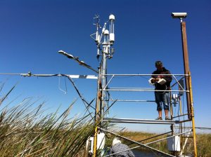
 mayberry scaffold
Keywords: —
Location: California, United States
View in Original Size
To download, right-click photo (Mac: control-click) and choose Save Image As
 US-Myb
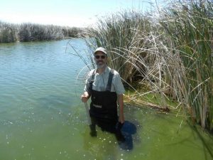
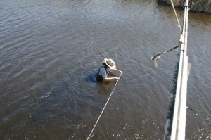
 ddb in the mayberry wetland
Keywords: —
Location: California, United States
View in Original Size
To download, right-click photo (Mac: control-click) and choose Save Image As
 US-Myb
 mayberry winter
bould corn tower
Keywords: —
Location: California, United States
View in Original Size
To download, right-click photo (Mac: control-click) and choose Save Image As
 US-Myb
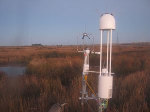
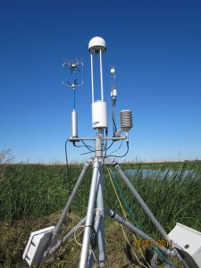
 MayberryFluxTower
flux tower on Mayberry in 2011
Keywords: —
Location:
View in Original Size
To download, right-click photo (Mac: control-click) and choose Save Image As
 US-Myb
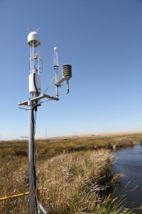
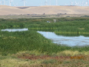
 Mayberry wetland
flux tower and veg and fetch
Keywords: —
Location: California, United States
View in Original Size
To download, right-click photo (Mac: control-click) and choose Save Image As
 US-Myb
 Cristina Poindexter, AmeriFlux Data Team, is measuring instrument locations at Mayberry Island (US_Myb). This provided her first-person experience of what is involved in mapping out instrumentation on a flux site.
Keywords: —
Location: California, United States
View in Original Size
To download, right-click photo (Mac: control-click) and choose Save Image As
US-Myb: Mayberry Wetland
- Overview
- Windroses
- Data Citation
- Data Use Log
- Image Gallery
- Remote Sensing Data
- MODIS
- PhenoCam
- GeoNEX
- Publications
- BADM
MODIS NDVI
The time series shows the 16-day Normalized Difference Vegetation Index (NDVI) average from the MOD13Q1 data product.
Use the slider below the time series to zoom in and out.
To view / download these data and other MOD13Q1 products for this site, visit MODIS/Terra Vegetation Indices.
For other related products, visit MODIS/VIIRS Fixed Sites Subsets Tool.
Citation:
ORNL DAAC. 2018. Terrestrial Ecology Subsetting & Visualization Services (TESViS) Fixed Sites Subsets. ORNL DAAC, Oak Ridge, Tennessee, USA. https://doi.org/10.3334/ORNLDAAC/1567
MODIS NDVI subsetted data is not yet available for this site.
For a complete list of AmeriFlux sites, visit ORNL DAAC's MODIS/VIIRS Fixed Sites Subsets Tool.


US-Myb: Mayberry Wetland
- Overview
- Windroses
- Data Citation
- Data Use Log
- Image Gallery
- Remote Sensing Data
- MODIS
- PhenoCam
- GeoNEX
- Publications
- BADM
| AmeriFlux Publications | Add Publication |
| Year | Publication |
|---|---|
| 2021 | Arias‐Ortiz, A., Oikawa, P. Y., Carlin, J., Masqué, P., Shahan, J., Kanneg, S., Paytan, A., Baldocchi, D. D. (2021) Tidal And Nontidal Marsh Restoration: A Trade‐Off Between Carbon Sequestration, Methane Emissions, And Soil Accretion, Journal Of Geophysical Research: Biogeosciences, 126(12), . https://doi.org/10.1029/2021JG006573 |
| 2021 | Valach, Alex C. Kasak, Kuno Hemes, Kyle S. Szutu, Daphne Verfaillie, Joe Baldocchi, Dennis D. (2021) Carbon Flux Trajectories and Site Conditions from Restored Impounded Marshes in the Sacramento-San Joaquin Delta, Wetland Carbon and Environmental Management, . https://doi.org/10.1002/9781119639305.ch13 |
| 2021 | Valach, A. C., Kasak, K., Hemes, K. S., Anthony, T. L., Dronova, I., Taddeo, S., Silver, W. L., Szutu, D., Verfaillie, J., Baldocchi, D. D. (2021) Productive Wetlands Restored For Carbon Sequestration Quickly Become Net Co2 Sinks With Site-Level Factors Driving Uptake Variability, Plos One, 16(3), e0248398. https://doi.org/10.1371/journal.pone.0248398 |
| 2021 | Rey‐Sanchez, C., Wharton, S., Vilà‐Guerau de Arellano, J., Paw U, K. T., Hemes, K. S., Fuentes, J. D., Osuna, J., Szutu, D., Ribeiro, J. V., Verfaillie, J., Baldocchi, D. (2021) Evaluation Of Atmospheric Boundary Layer Height From Wind Profiling Radar And Slab Models And Its Responses To Seasonality Of Land Cover, Subsidence, And Advection, Journal Of Geophysical Research: Atmospheres, 126(7), . https://doi.org/10.1029/2020JD033775 |
| 2021 | Chu, H., Luo, X., Ouyang, Z., Chan, W. S., Dengel, S., Biraud, S. C., Torn, M. S., Metzger, S., Kumar, J., Arain, M. A., Arkebauer, T. J., Baldocchi, D., Bernacchi, C., Billesbach, D., Black, T. A., Blanken, P. D., Bohrer, G., Bracho, R., Brown, S., Brunsell, N. A., Chen, J., Chen, X., Clark, K., Desai, A. R., Duman, T., Durden, D., Fares, S., Forbrich, I., Gamon, J. A., Gough, C. M., Griffis, T., Helbig, M., Hollinger, D., Humphreys, E., Ikawa, H., Iwata, H., Ju, Y., Knowles, J. F., Knox, S. H., Kobayashi, H., Kolb, T., Law, B., Lee, X., Litvak, M., Liu, H., Munger, J. W., Noormets, A., Novick, K., Oberbauer, S. F., Oechel, W., Oikawa, P., Papuga, S. A., Pendall, E., Prajapati, P., Prueger, J., Quinton, W. L., Richardson, A. D., Russell, E. S., Scott, R. L., Starr, G., Staebler, R., Stoy, P. C., Stuart-Haëntjens, E., Sonnentag, O., Sullivan, R. C., Suyker, A., Ueyama, M., Vargas, R., Wood, J. D., Zona, D. (2021) Representativeness Of Eddy-Covariance Flux Footprints For Areas Surrounding Ameriflux Sites, Agricultural And Forest Meteorology, 301-302, 108350. https://doi.org/10.1016/j.agrformet.2021.108350 |
| 2019 | Chamberlain, S. D., Hemes, K. S., Eichelmann, E., Szutu, D. J., Verfaillie, J. G., Baldocchi, D. D. (2019) Effect Of Drought-Induced Salinization On Wetland Methane Emissions, Gross Ecosystem Productivity, And Their Interactions, Ecosystems, . https://doi.org/10.1007/s10021-019-00430-5 |
| 2019 | Sullivan, R. C., Kotamarthi, V. R., Feng, Y. (2019) Recovering Evapotranspiration Trends From Biased CMIP5 Simulations And Sensitivity To Changing Climate Over North America, Journal Of Hydrometeorology, 20(8), 1619-1633. https://doi.org/10.1175/JHM-D-18-0259.1 |
| 2019 | Sullivan, R. C., Cook, D. R., Ghate, V. P., Kotamarthi, V. R., Feng, Y. (2019) Improved Spatiotemporal Representativeness And Bias Reduction Of Satellite-Based Evapotranspiration Retrievals Via Use Of In Situ Meteorology And Constrained Canopy Surface Resistance, Journal Of Geophysical Research: Biogeosciences, 124(2), 342-352. https://doi.org/10.1029/2018JG004744 |
| 2019 | Hemes, K. S., Chamberlain, S. D., Eichelmann, E., Anthony, T., Valach, A., Kasak, K., Szutu, D., Verfaillie, J., Silver, W. L., Baldocchi, D. D. (2019) Assessing The Carbon And Climate Benefit Of Restoring Degraded Agricultural Peat Soils To Managed Wetlands, Agricultural And Forest Meteorology, 268, 202-214. https://doi.org/10.1016/j.agrformet.2019.01.017 |
| 2018 | Baldocchi, D., Penuelas, J. (2018) The Physics And Ecology Of Mining Carbon Dioxide From The Atmosphere By Ecosystems, Global Change Biology, . https://doi.org/10.1111/gcb.14559 |
| 2018 | Hemes, K. S., Chamberlain, S. D., Eichelmann, E., Knox, S. H., Baldocchi, D. D. (2018) A Biogeochemical Compromise: The High Methane Cost Of Sequestering Carbon In Restored Wetlands, Geophysical Research Letters, . https://doi.org/10.1029/2018GL077747 |
| 2018 | Hemes, K. S., Eichelmann, E., Chamberlain, S., Knox, S. H., Oikawa, P. Y., Sturtevant, C., Verfaillie, J., Szutu, D., Baldocchi, D. D. (2018) A Unique Combination Of Aerodynamic And Surface Properties Contribute To Surface Cooling In Restored Wetlands Of The Sacramento-San Joaquin Delta, California, Journal Of Geophysical Research: Biogeosciences, . https://doi.org/10.1029/2018JG004494 |
| 2018 | Eichelmann, E., Hemes, K. S., Knox, S. H., Oikawa, P. Y., Chamberlain, S. D., Sturtevant, C., Verfaillie, J., Baldocchi, D. D. (2018) The Effect Of Land Cover Type And Structure On Evapotranspiration From Agricultural And Wetland Sites In The Sacramento–San Joaquin River Delta, California, Agricultural And Forest Meteorology, 256-257, 179-195. https://doi.org/10.1016/j.agrformet.2018.03.007 |
| 2014 | Matthes, J. H., Sturtevant, C., Verfaillie, J., Knox, S., Baldocchi, D. (2014) Parsing The Variability In Ch4 flux At A Spatially Heterogeneous Wetland: Integrating Multiple Eddy Covariance Towers With High-Resolution Flux Footprint Analysis, Journal Of Geophysical Research: Biogeosciences, 119(7), 1322-1339. https://doi.org/10.1002/2014JG002642 |
| 2017 | Chamberlain, S. D., Verfaillie, J., Eichelmann, E., Hemes, K. S., Baldocchi, D. D. (2017) Evaluation Of Density Corrections To Methane Fluxes Measured By Open-Path Eddy Covariance Over Contrasting Landscapes, Boundary-Layer Meteorology, . https://doi.org/10.1007/s10546-017-0275-9 |
| 2016 | McNicol, G., C. S. Sturtevant, S. H. Knox, I. Dronova, D. D. Baldocchi, and W. L. Silver. (2016) 2016. Effects of seasonality, transport-pathway, and spatial structure on greenhouse gas fluxes in a restored wetland., Global Change Biology, nnn-nnn. https://doi.org/10.1111/gcb.13580 |
| 2015 | Sturtevant, C., B. L. Ruddell, S. H. Knox, J. Verfaillie, J. H. Matthes, P. Y. Oikawa, and D. Baldocchi. (2015) 2015. Identifying scale-emergent, non-linear, asynchronous processes of wetland methane exchange., Journal of Geophysical Research: Biogeosciences, 121, 188-204. https://doi.org/10.1002/2015jg003054 |
| 2017 | Knox, Sara Helen Dronova, Iryna Sturtevant, Cove Oikawa, Patricia Y. Matthes, Jaclyn Hatala Verfaillie, Joseph Baldocchi, Dennis (2017) Using digital camera and Landsat imagery with eddy covariance data to model gross primary production in restored wetlands, Agricultural and Forest Meteorology, 237–238, 233-245. https://doi.org/https://dx.doi.org/10.1016/j.agrformet.2017.02.020 |
| 2017 | Oikawa, P. Y.; Jenerette, G. D.; Knox, S. H.; Sturtevant, C.; Verfaillie, J.; Dronova, I.; Poindexter, C. M. ; Eichelmann, E.; Baldocchi, D. D. (2017) Evaluation of a hierarchy of models reveals importance of substrate limitation for predicting carbon dioxide and methane exchange in restored wetlands, Journal of Geophysical Research: Biogeosciences, 122(1), 145-167. https://doi.org/10.1002/2016JG003438 |
| 2014 | Knox, S. H.,, Sturtevant, C., Matthes, J.H., Koteen, L., Verfaillie,J., Baldocchi. D. (2014) Agricultural peatland restoration: effects of land-use change on greenhouse gas (CO2 and CH4) fluxes in the Sacramento-San Joaquin Delta, Global Change Biology, 21, 750-765. https://doi.org/10.1111/gcb.12745 |
US-Myb: Mayberry Wetland
- Overview
- Windroses
- Data Citation
- Data Use Log
- Image Gallery
- Remote Sensing Data
- MODIS
- PhenoCam
- GeoNEX
- Publications
- BADM
BADM for This Site
Access the Biological, Ancillary, Disturbance and Metadata (BADM) information and data for this site.
BADM contain information for many uses, such as characterizing a site’s vegetation and soil, describing disturbance history, and defining instrumentation for flux processing. They complement the flux/met data.
- Download BADM for this site*
- View Site General Info for this site (Overview tab)*
- Use Online Editor to update Site General Info or DOI Authorship
- Update information about submitted data (Variable Information tool)
- More BADM resources
* Online updates are shown on the Overview tab real time. However, downloaded BADM files will not reflect those updates until they have been reviewed for QA/QC.
US-Myb: Mayberry Wetland
- Overview
- Windroses
- Data Citation
- Data Use Log
- Image Gallery
- Remote Sensing Data
- MODIS
- PhenoCam
- GeoNEX
- Publications
- BADM
Wind Roses
Wind Speed (m/s)
- Wind Speed Scale: Per Site
- Wind Direction Scale (%): Per Site
- Wind Speed Scale: Non-Linear
- Wind Direction Scale (%): AmeriFlux