
US-Los: Lost Creek
- Overview
- Windroses
- Data Citation
- Data Use Log
- Image Gallery
- Remote Sensing Data
- MODIS
- PhenoCam
- GeoNEX
- Publications
- BADM
| Tower_team: | |
| PI: | Ankur Desai desai@aos.wisc.edu - University of Wisconsin |
| FluxContact: | Jonathan Thom jthom@ssec.wisc.edu - University of Wisconsin |
| Lat, Long: | 46.0827, -89.9792 |
| Elevation(m): | 480.00 |
| Network Affiliations: | AmeriFlux, Phenocam |
| Vegetation IGBP: | WET (Permanent Wetlands: Lands with a permanent mixture of water and herbaceous or woody vegetation that cover extensive areas. The vegetation can be present in either salt, brackish, or fresh water) |
| Climate Koeppen: | Dfb (Warm Summer Continental: significant precipitation in all seasons ) |
| Mean Annual Temp (°C): | 4.08 |
| Mean Annual Precip. (mm): | 828 |
| Flux Species Measured: | CO2, H, H2O, CH4 |
| Years Data Collected: | 2001 - Present |
| Years Data Available: | AmeriFlux BASE 2000 - 2025 Data Citation |
| Data Use Policy: | AmeriFlux CC-BY-4.0 Policy1 |
| Description: | |
| URL: | http://flux.aos.wisc.edu/twiki/bin/view/Main/ChEASData |
| Research Topics: | |
| Acknowledgment: | — |
- This site’s data can also be used under the more restrictive AmeriFlux Legacy Policy.
The AmeriFlux Legacy Policy must be followed if this site’s data are combined with data from sites that require the AmeriFlux Legacy Policy.
Copyright preference: Request for permission
US-Los: Lost Creek
- Overview
- Windroses
- Data Citation
- Data Use Log
- Image Gallery
- Remote Sensing Data
- MODIS
- PhenoCam
- GeoNEX
- Publications
- BADM
Use the information below for citation of this site. See the Data Policy page for more details.
DOI(s) for citing US-Los data
Data Use Policy: AmeriFlux CC-BY-4.0 License
This site’s data can also be used under the more restrictive AmeriFlux Legacy Policy.
The AmeriFlux Legacy Policy must be followed if US-Los data are combined with data from sites that require the AmeriFlux Legacy Policy.
- AmeriFlux BASE: https://doi.org/10.17190/AMF/1246071
Citation: Ankur Desai (2025), AmeriFlux BASE US-Los Lost Creek, Ver. 34-5, AmeriFlux AMP, (Dataset). https://doi.org/10.17190/AMF/1246071
To cite BADM when downloaded on their own, use the publications below for citing site characterization. When using BADM that are downloaded with AmeriFlux BASE and AmeriFlux FLUXNET products, use the DOI citation for the associated data product.
Publication(s) for citing site characterization
- —
Acknowledgments
- —
Resources
- AmeriFlux Logos & Acknowledgments
US-Los: Lost Creek
- Overview
- Windroses
- Data Citation
- Data Use Log
- Image Gallery
- Remote Sensing Data
- MODIS
- PhenoCam
- GeoNEX
- Publications
- BADM

This page displays the list of downloads of data for the site {{siteId}}.
Note: Results are the number of downloads to distinct data users. The Download Count column indicates the number of times the data user downloaded the data. The Version column refers to the version of the data product for the site that was downloaded by the data user.
| Date | Name | Data Product | Vers. | Intended Use | Intended Use Description | Download Count |
|---|---|---|---|---|---|---|
| {{dlObject.timeStamp}} | {{dlObject.displayName}} | {{displayProduct(dlObject.dataProduct)}} | {{dlObject.version}} | {{dlObject.intendedUse}} | {{dlObject.comment}} | {{dlObject.downloadCounter}} |
Showing {{startItem + 1}} to {{(startItem + items) > filtered.length ? filtered.length : (startItem + items)}} of {{filtered.length}} results
Showing 0 to 0 of 0 results
Not Found
Uh Oh. Something is missing. Try double checking the URL and try again.
US-Los: Lost Creek
- Overview
- Windroses
- Data Citation
- Data Use Log
- Image Gallery
- Remote Sensing Data
- MODIS
- PhenoCam
- GeoNEX
- Publications
- BADM
| AmeriFlux Images | Add Image |
US-Los 2015.US.Los.Sitevisit.vlcsnap-2015-08-21-16h42m21s152
2015.US.Los.Sitevisit.vlcsnap-2015-08-21-16h42m21s152
Keywords: —
Location:
View in Original Size
To download, right-click photo (Mac: control-click) and choose Save Image As
 US-Los
 2015.US.LosSitevisit.vlcsnap-2017-03-23-16h52m09s130
2015.US.Los.Sitevisit.vlcsnap-2017-03-23-16h52m09s130
Keywords: —
Location:
View in Original Size
To download, right-click photo (Mac: control-click) and choose Save Image As
 US-Los
 2015.US.Los.Sitevisit.vlcsnap-2017-03-23-16h54m24s193
2015.US.Los.Sitevisit.vlcsnap-2017-03-23-16h54m24s193
Keywords: —
Location:
View in Original Size
To download, right-click photo (Mac: control-click) and choose Save Image As
 US-Los
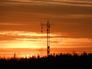
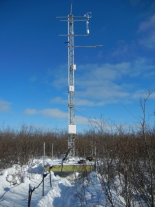
 Lost Creek at sunset
November sunset at Lost Creek flux tower. Heading to the site to the clean the mirrors on the LI7700 again. Unseasonably, warm November in Wisconsin and a beautiful day in the field.
Keywords: Lost Creek, tower, sunset
Location: Wisconsin, United States
View in Original Size
To download, right-click photo (Mac: control-click) and choose Save Image As
 US-Los
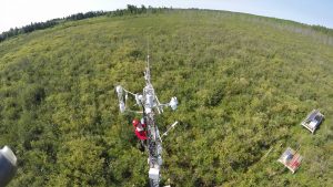
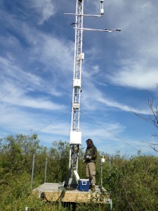
 New Lost Creek (US-Los) tower.
Last week the US-Los (Lost Creek) tower was updated. The original tower was an aluminum tilt down tower that was not meant to be climbed. The tower was replaced with a Rohn 25G tower, new guy lines and anchors. The new tower is easier to climb, easier to mount instruments and provides better torsional stability. The placement of the solar radiation sensors was adjusted to be farther from the IRGAs because of concern of getting reflected solar radiation. The current instrument arm for the net radiation sensors will be extended to clear the guy line and provide even more clearance from the other sensors. The new tower includes a vertical axis wind turbine to provide additional charging to the solar array and batteries.
Keywords: Lost Creek, tower, solar radiation
Location: Wisconsin, United States
View in Original Size
To download, right-click photo (Mac: control-click) and choose Save Image As
 US-Los
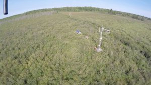
 Mosquitos love wetlands
UW undergraduate Nick Hill samples vegetation and protects himself from mosquito bites at Lost Creek wetland.
Keywords: wetland, US-Los
Location: Wisconsin, United States
View in Original Size
To download, right-click photo (Mac: control-click) and choose Save Image As
 US-Los
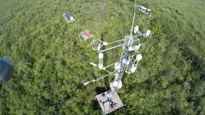
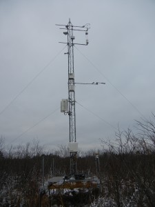
 Lost Creek Tower
Keywords: —
Location: Wisconsin, United States
View in Original Size
To download, right-click photo (Mac: control-click) and choose Save Image As
US-Los: Lost Creek
- Overview
- Windroses
- Data Citation
- Data Use Log
- Image Gallery
- Remote Sensing Data
- MODIS
- PhenoCam
- GeoNEX
- Publications
- BADM
MODIS NDVI
The time series shows the 16-day Normalized Difference Vegetation Index (NDVI) average from the MOD13Q1 data product.
Use the slider below the time series to zoom in and out.
To view / download these data and other MOD13Q1 products for this site, visit MODIS/Terra Vegetation Indices.
For other related products, visit MODIS/VIIRS Fixed Sites Subsets Tool.
Citation:
ORNL DAAC. 2018. Terrestrial Ecology Subsetting & Visualization Services (TESViS) Fixed Sites Subsets. ORNL DAAC, Oak Ridge, Tennessee, USA. https://doi.org/10.3334/ORNLDAAC/1567
MODIS NDVI subsetted data is not yet available for this site.
For a complete list of AmeriFlux sites, visit ORNL DAAC's MODIS/VIIRS Fixed Sites Subsets Tool.


US-Los: Lost Creek
- Overview
- Windroses
- Data Citation
- Data Use Log
- Image Gallery
- Remote Sensing Data
- MODIS
- PhenoCam
- GeoNEX
- Publications
- BADM
| AmeriFlux Publications | Add Publication |
| Year | Publication |
|---|---|
| 2021 | Chu, H., Luo, X., Ouyang, Z., Chan, W. S., Dengel, S., Biraud, S. C., Torn, M. S., Metzger, S., Kumar, J., Arain, M. A., Arkebauer, T. J., Baldocchi, D., Bernacchi, C., Billesbach, D., Black, T. A., Blanken, P. D., Bohrer, G., Bracho, R., Brown, S., Brunsell, N. A., Chen, J., Chen, X., Clark, K., Desai, A. R., Duman, T., Durden, D., Fares, S., Forbrich, I., Gamon, J. A., Gough, C. M., Griffis, T., Helbig, M., Hollinger, D., Humphreys, E., Ikawa, H., Iwata, H., Ju, Y., Knowles, J. F., Knox, S. H., Kobayashi, H., Kolb, T., Law, B., Lee, X., Litvak, M., Liu, H., Munger, J. W., Noormets, A., Novick, K., Oberbauer, S. F., Oechel, W., Oikawa, P., Papuga, S. A., Pendall, E., Prajapati, P., Prueger, J., Quinton, W. L., Richardson, A. D., Russell, E. S., Scott, R. L., Starr, G., Staebler, R., Stoy, P. C., Stuart-Haëntjens, E., Sonnentag, O., Sullivan, R. C., Suyker, A., Ueyama, M., Vargas, R., Wood, J. D., Zona, D. (2021) Representativeness Of Eddy-Covariance Flux Footprints For Areas Surrounding Ameriflux Sites, Agricultural And Forest Meteorology, 301-302, 108350. https://doi.org/10.1016/j.agrformet.2021.108350 |
| 2013 | Barr, A., Richardson, A., Hollinger, D., Papale, D., Arain, M., Black, T., Bohrer, G., Dragoni, D., Fischer, M., Gu, L., Law, B., Margolis, H., McCaughey, J., Munger, J., Oechel, W., Schaeffer, K. (2013) Use Of Change-Point Detection For Friction–Velocity Threshold Evaluation In Eddy-Covariance Studies, Agricultural And Forest Meteorology, 171-172, 31-45. https://doi.org/10.1016/j.agrformet.2012.11.023 |
| 2018 | Reed, D. E., Frank, J. M., Ewers, B. E., Desai, A. R. (2018) Time Dependency Of Eddy Covariance Site Energy Balance, Agricultural And Forest Meteorology, 249, 467-478. https://doi.org/10.1016/j.agrformet.2017.08.008 |
| 2018 | Pugh, C. A., Reed, D. E., Desai, A. R., Sulman, B. N. (2018) Wetland Flux Controls: How Does Interacting Water Table Levels And Temperature Influence Carbon Dioxide And Methane Fluxes In Northern Wisconsin?, Biogeochemistry, 137(1-2), 15-25. https://doi.org/10.1007/s10533-017-0414-x |
| 2019 | Bechtold, M., De Lannoy, G. J., Koster, R. D., Reichle, R. H., Mahanama, S. P., Bleuten, W., Bourgault, M. A., Brümmer, C., Burdun, I., Desai, A. R., Devito, K., Grünwald, T., Grygoruk, M., Humphreys, E. R., Klatt, J., Kurbatova, J., Lohila, A., Munir, T. M., Nilsson, M. B., Price, J. S., Röhl, M., Schneider, A., Tiemeyer, B. (2019) Peat‐Clsm: A Specific Treatment Of Peatland Hydrology In The Nasa Catchment Land Surface Model, Journal Of Advances In Modeling Earth Systems, 11(7), 2130-2162. https://doi.org/10.1029/2018MS001574 |
| 2019 | Knox, S. H., Jackson, R. B., Poulter, B., McNicol, G., Fluet-Chouinard, E., Zhang, Z., Hugelius, G., Bousquet, P., Canadell, J. G., Saunois, M., Papale, D., Chu, H., Keenan, T. F., Baldocchi, D., Torn, M. S., Mammarella, I., Trotta, C., Aurela, M., Bohrer, G., Campbell, D. I., Cescatti, A., Chamberlain, S., Chen, J., Chen, W., Dengel, S., Desai, A. R., Euskirchen, E., Friborg, T., Gasbarra, D., Goded, I., Goeckede, M., Heimann, M., Helbig, M., Hirano, T., Hollinger, D. Y., Iwata, H., Kang, M., Klatt, J., Krauss, K. W., Kutzbach, L., Lohila, A., Mitra, B., Morin, T. H., Nilsson, M. B., Niu, S., Noormets, A., Oechel, W. C., Peichl, M., Peltola, O., Reba, M. L., Richardson, A. D., Runkle, B. R., Ryu, Y., Sachs, T., Schäfer, K. V., Schmid, H. P., Shurpali, N., Sonnentag, O., Tang, A. C., Ueyama, M., Vargas, R., Vesala, T., Ward, E. J., Windham-Myers, L., Wohlfahrt, G., Zona, D. (2019) Fluxnet-Ch4 Synthesis Activity: Objectives, Observations, And Future Directions, Bulletin Of The American Meteorological Society, . https://doi.org/10.1175/BAMS-D-18-0268.1 |
| 2019 | Turner, J., Desai, A. R., Thom, J., Wickland, K. P., Olson, B. (2019) Wind Sheltering Impacts On Land-Atmosphere Fluxes Over Fens, Frontiers In Environmental Science, 7, . https://doi.org/10.3389/fenvs.2019.00179 |
| 2019 | Sullivan, R. C., Kotamarthi, V. R., Feng, Y. (2019) Recovering Evapotranspiration Trends From Biased CMIP5 Simulations And Sensitivity To Changing Climate Over North America, Journal Of Hydrometeorology, 20(8), 1619-1633. https://doi.org/10.1175/JHM-D-18-0259.1 |
| 2019 | Sullivan, R. C., Cook, D. R., Ghate, V. P., Kotamarthi, V. R., Feng, Y. (2019) Improved Spatiotemporal Representativeness And Bias Reduction Of Satellite-Based Evapotranspiration Retrievals Via Use Of In Situ Meteorology And Constrained Canopy Surface Resistance, Journal Of Geophysical Research: Biogeosciences, 124(2), 342-352. https://doi.org/10.1029/2018JG004744 |
| 2018 | Qiu, C., Zhu, D., Ciais, P., Guenet, B., Krinner, G., Peng, S., Aurela, M., Bernhofer, C., Brümmer, C., Bret-Harte, S., Chu, H., Chen, J., Desai, A. R., Dušek, J., Euskirchen, E. S., Fortuniak, K., Flanagan, L. B., Friborg, T., Grygoruk, M., Gogo, S., Grünwald, T., Hansen, B. U., Holl, D., Humphreys, E., Hurkuck, M., Kiely, G., Klatt, J., Kutzbach, L., Largeron, C., Laggoun-Défarge, F., Lund, M., Lafleur, P. M., Li, X., Mammarella, I., Merbold, L., Nilsson, M. B., Olejnik, J., Ottosson-Löfvenius, M., Oechel, W., Parmentier, F. W., Peichl, M., Pirk, N., Peltola, O., Pawlak, W., Rasse, D., Rinne, J., Shaver, G., Schmid, H. P., Sottocornola, M., Steinbrecher, R., Sachs, T., Urbaniak, M., Zona, D., Ziemblinska, K. (2018) Orchidee-Peat (Revision 4596), A Model For Northern Peatland Co≪Sub≫2≪/Sub≫, Water, And Energy Fluxes On Daily To Annual Scales, Geoscientific Model Development, 11(2), 497-519. https://doi.org/10.5194/gmd-11-497-2018 |
| 2003 | Scott Denning, A., Nicholls, M., Prihodko, L., Baker, I., Vidale, P., Davis, K., Bakwin, P. (2003) Simulated Variations In Atmospheric CO2 Over A Wisconsin Forest Using A Coupled Ecosystem-Atmosphere Model, Global Change Biology, 9(9), 1241-1250. https://doi.org/10.1046/j.1365-2486.2003.00613.x |
| 2004 | Cook, B. D., Davis, K. J., Wang, W., Desai, A., Berger, B. W., Teclaw, R. M., Martin, J. G., Bolstad, P. V., Bakwin, P. S., Yi, C., Heilman, W. (2004) Carbon Exchange And Venting Anomalies In An Upland Deciduous Forest In Northern Wisconsin, USA, Agricultural And Forest Meteorology, 126(3-4), 271-295. https://doi.org/10.1016/j.agrformet.2004.06.008 |
| 2009 | Sulman, B.N., Desai, A.R., Cook, B.D., Saliendra, N., Mackay, D.S. (2009) Contrasting Carbon Dioxide Fluxes Between A Drying Shrub Wetland In Northern Wisconsin, USA, And Nearby Forests, Biogeosciences, 6(6), 1115-1126. https://doi.org/10.5194/bg-6-1115-2009 |
| 2004 | Kaakinen, S., Kostiainen, K., Ek, F., Saranpaa, P., Kubiske, M. E., Sober, J., Karnosky, D. F., Vapaavuori, E. (2004) Stem Wood Properties Of Populus Tremuloides, Betula Papyrifera And Acer Saccharum Saplings After 3 Years Of Treatments To Elevated Carbon Dioxide And Ozone, Global Change Biology, 10(9), 1513-1525. https://doi.org/10.1111/j.1365-2486.2004.00814.x |
| 2010 | Desai, A.R. (2010) Climatic And Phenological Controls On Coherent Regional Interannual Variability Of Carbon Dioxide Flux In A Heterogeneous Landscape, Journal Of Geophysical Research, 115(G00J02), n/a-n/a. https://doi.org/10.1029/2010JG001423 |
| 2003 | Davis, K. J., Bakwin, P. S., Yi, C., Berger, B. W., Zhao, C., Teclaw, R. M., Isebrands, J. G. (2003) The Annual Cycles Of CO2 And H2O Exchange Over A Northern Mixed Forest As Observed From A Very Tall Tower, Global Change Biology, 9(9), 1278-1293. https://doi.org/10.1046/j.1365-2486.2003.00672.x |
| 2003 | Werner, C., Davis, K., Bakwin, P., Yi, C., Hurst, D., Lock, L. (2003) Regional-Scale Measurements Of CH4 Exchange From A Tall Tower Over A Mixed Temperate/Boreal Lowland And Wetland Forest, Global Change Biology, 9(9), 1251-1261. https://doi.org/10.1046/j.1365-2486.2003.00670.x |
| 2013 | Sulman, B. N., Desai, A. R., Mladenoff, D. J. (2013) Modeling Soil And Biomass Carbon Responses To Declining Water Table In A Wetland-Rich Landscape, Ecosystems, 16(3), 491-507. https://doi.org/10.1007/s10021-012-9624-1 |
| 2004 | Bakwin, P. S., Davis, K. J., Yi, C., Wofsy, S. C., Munger, J. W., Haszpra, L., Barcza, Z. (2004) Regional Carbon Dioxide Fluxes From Mixing Ratio Data, Tellus Series B-Chemical and Physical Meteorology, 56(4), 301-311. https://doi.org/10.3402/tellusb.v56i4.16446 |
| 2010 | Sulman, B. N., Desai, A. R., Saliendra, N. Z., Lafleur, P. M., Flanagan, L. B., Sonnentag, O., Mackay, D. S., Barr, A. G., van der Kamp, G. (2010) CO2 Fluxes At Northern Fens And Bogs Have Opposite Responses To Inter-Annual Fluctuations In Water Table, Geophysical Research Letters, 37(19), n/a-n/a. https://doi.org/10.1029/2010GL044018 |
| 2008 | Desai, A. R., Noormets, A., Bolstad, P. V., Chen, J., Cook, B. D., Davis, K. J., Euskirchen, E. S., Gough, C., Martin, J. G., Ricciuto, D. M., Schmid, H. P., Tang, J., Wang, W. (2008) Influence Of Vegetation And Seasonal Forcing On Carbon Dioxide Fluxes Across The Upper Midwest, Usa: Implications For Regional Scaling, Agricultural And Forest Meteorology, 148(2), 288-308. https://doi.org/10.1016/j.agrformet.2007.08.001 |
| 2004 | Yi, C., Davis, K. J., Bakwin, P. S., Denning, A. S., Zhang, N., Desai, A., Lin, J. C., Gerbig, C. (2004) Observed Covariance Between Ecosystem Carbon Exchange And Atmospheric Boundary Layer Dynamics At A Site In Northern Wisconsin, Journal Of Geophysical Research: Atmospheres, 109(D8), n/a-n/a. https://doi.org/10.1029/2003jd004164 |
| 2004 | Yi, C., Li, R., Bakwin, P. S., Desai, A., Ricciuto, D. M., Burns, S. P., Turnipseed, A. A., Wofsy, S. C., Munger, J. W., Wilson, K., Monson, R. K. (2004) A Nonparametric Method For Separating Photosynthesis And Respiration Components In CO2 Flux Measurements, Geophysical Research Letters, 31(17), n/a-n/a. https://doi.org/10.1029/2004gl020490 |
| 2012 | Grant, R.F., Desai, A.R., Sulman, B.N. (2012) Modelling Contrasting Responses Of Wetland Productivity To Changes In Water Table Depth, Biogeosciences, 9(11), 4215-4231. https://doi.org/10.5194/bg-9-4215-2012 |
| 2003 | Baker, I., Denning, A. S., Hanan, N., Prihodko, L., Uliasz, M., Vidale, P., Davis, K., Bakwin, P. (2003) Simulated And Observed Fluxes Of Sensible And Latent Heat And CO2 At The WLEF-TV Tower Using SiB2.5, Global Change Biology, 9(9), 1262-1277. https://doi.org/10.1046/j.1365-2486.2003.00671.x |
| 2012 | Sulman, B. N., Desai, A. R., Schroeder, N. M., Ricciuto, D., Barr, A., Richardson, A. D., Flanagan, L. B., Lafleur, P. M., Tian, H., Chen, G., Grant, R. F., Poulter, B., Verbeeck, H., Ciais, P., Ringeval, B., Baker, I. T., Schaefer, K., Luo, Y., Weng, E. (2012) Impact of Hydrological Variations on Modeling of Peatland CO2 Fluxes: Results From the North American Carbon Program Site Synthesis, Journal Of Geophysical Research: Biogeosciences, 117(G01031), n/a-n/a. https://doi.org/10.1029/2011JG001862 |
US-Los: Lost Creek
- Overview
- Windroses
- Data Citation
- Data Use Log
- Image Gallery
- Remote Sensing Data
- MODIS
- PhenoCam
- GeoNEX
- Publications
- BADM
BADM for This Site
Access the Biological, Ancillary, Disturbance and Metadata (BADM) information and data for this site.
BADM contain information for many uses, such as characterizing a site’s vegetation and soil, describing disturbance history, and defining instrumentation for flux processing. They complement the flux/met data.
- Download BADM for this site*
- View Site General Info for this site (Overview tab)*
- Use Online Editor to update Site General Info or DOI Authorship
- Update information about submitted data (Variable Information tool)
- More BADM resources
* Online updates are shown on the Overview tab real time. However, downloaded BADM files will not reflect those updates until they have been reviewed for QA/QC.
US-Los: Lost Creek
- Overview
- Windroses
- Data Citation
- Data Use Log
- Image Gallery
- Remote Sensing Data
- MODIS
- PhenoCam
- GeoNEX
- Publications
- BADM
Wind Roses
Wind Speed (m/s)
- Wind Speed Scale: Per Site
- Wind Direction Scale (%): Per Site
- Wind Speed Scale: Non-Linear
- Wind Direction Scale (%): AmeriFlux