
US-Seg: Sevilleta grassland
- Overview
- Windroses
- Data Citation
- Data Use Log
- Image Gallery
- Remote Sensing Data
- MODIS
- PhenoCam
- GeoNEX
- Publications
- BADM
| Tower_team: | |
| PI: | Marcy Litvak mlitvak@unm.edu - University of New Mexico |
| DataManager: | Kai Del Regno kaidelregno@unm.edu - University of New Mexico |
| Technician: | Bishop Cervantes bmcervantes@unm.edu - University of New Mexico |
| Lat, Long: | 34.3623, -106.7020 |
| Elevation(m): | 1596 |
| Network Affiliations: | AmeriFlux, Phenocam |
| Vegetation IGBP: | GRA (Grasslands: Lands with herbaceous types of cover. Tree and shrub cover is less than 10%. Permanent wetlands lands with a permanent mixture of water and herbaceous or woody vegetation. The vegetation can be present in either salt, brackish, or fresh water.) |
| Climate Koeppen: | Bsk (Steppe: warm winter) |
| Mean Annual Temp (°C): | 13.667 |
| Mean Annual Precip. (mm): | 273.304 |
| Flux Species Measured: | CO2, H2O |
| Years Data Collected: | 2007 - Present |
| Years Data Available: | AmeriFlux BASE 2007 - 2025 Data Citation AmeriFlux FLUXNET 2007 - 2025 Data Citation |
| Data Use Policy: | AmeriFlux CC-BY-4.0 Policy1 |
| Description: | |
| URL: | http://www.litvaklab.org/grassland.html |
| Research Topics: | |
| Acknowledgment: | — |
- This site’s data can also be used under the more restrictive AmeriFlux Legacy Policy.
The AmeriFlux Legacy Policy must be followed if this site’s data are combined with data from sites that require the AmeriFlux Legacy Policy.
Copyright preference: Open use
US-Seg: Sevilleta grassland
- Overview
- Windroses
- Data Citation
- Data Use Log
- Image Gallery
- Remote Sensing Data
- MODIS
- PhenoCam
- GeoNEX
- Publications
- BADM
Use the information below for citation of this site. See the Data Policy page for more details.
DOI(s) for citing US-Seg data
Data Use Policy: AmeriFlux CC-BY-4.0 License
This site’s data can also be used under the more restrictive AmeriFlux Legacy Policy.
The AmeriFlux Legacy Policy must be followed if US-Seg data are combined with data from sites that require the AmeriFlux Legacy Policy.
- AmeriFlux BASE: https://doi.org/10.17190/AMF/1246124
Citation: Marcy Litvak (2026), AmeriFlux BASE US-Seg Sevilleta grassland, Ver. 29-5, AmeriFlux AMP, (Dataset). https://doi.org/10.17190/AMF/1246124 - AmeriFlux FLUXNET: https://doi.org/10.17190/AMF/1984572
Citation: Marcy Litvak (2026), AmeriFlux FLUXNET-1F US-Seg Sevilleta grassland, Ver. v1.3_r1, AmeriFlux AMP, (Dataset). https://doi.org/10.17190/AMF/1984572
Find global FLUXNET datasets, like FLUXNET2015 and FLUXNET-CH4, and their citation information at fluxnet.org.
To cite BADM when downloaded on their own, use the publications below for citing site characterization. When using BADM that are downloaded with AmeriFlux BASE and AmeriFlux FLUXNET products, use the DOI citation for the associated data product.
Publication(s) for citing site characterization
- —
Acknowledgments
- —
Resources
- AmeriFlux Logos & Acknowledgments
US-Seg: Sevilleta grassland
- Overview
- Windroses
- Data Citation
- Data Use Log
- Image Gallery
- Remote Sensing Data
- MODIS
- PhenoCam
- GeoNEX
- Publications
- BADM

This page displays the list of downloads of data for the site {{siteId}}.
Note: Results are the number of downloads to distinct data users. The Download Count column indicates the number of times the data user downloaded the data. The Version column refers to the version of the data product for the site that was downloaded by the data user.
| Date | Name | Data Product | Vers. | Intended Use | Intended Use Description | Download Count |
|---|---|---|---|---|---|---|
| {{dlObject.timeStamp}} | {{dlObject.displayName}} | {{displayProduct(dlObject.dataProduct)}} | {{dlObject.version}} | {{dlObject.intendedUse}} | {{dlObject.comment}} | {{dlObject.downloadCounter}} |
Showing {{startItem + 1}} to {{(startItem + items) > filtered.length ? filtered.length : (startItem + items)}} of {{filtered.length}} results
Showing 0 to 0 of 0 results
Not Found
Uh Oh. Something is missing. Try double checking the URL and try again.
US-Seg: Sevilleta grassland
- Overview
- Windroses
- Data Citation
- Data Use Log
- Image Gallery
- Remote Sensing Data
- MODIS
- PhenoCam
- GeoNEX
- Publications
- BADM
| AmeriFlux Images | Add Image |
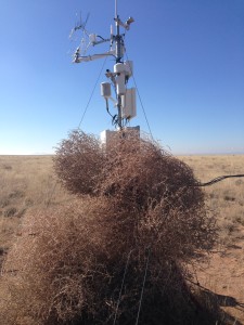
US-Seg Tumbleweed invasion of Grassland flux tower in the Sevilleta
Keywords: —
Location: New Mexico, United States
View in Original Size
To download, right-click photo (Mac: control-click) and choose Save Image As
US-Seg: Sevilleta grassland
- Overview
- Windroses
- Data Citation
- Data Use Log
- Image Gallery
- Remote Sensing Data
- MODIS
- PhenoCam
- GeoNEX
- Publications
- BADM
MODIS NDVI
The time series shows the 16-day Normalized Difference Vegetation Index (NDVI) average from the MOD13Q1 data product.
Use the slider below the time series to zoom in and out.
To view / download these data and other MOD13Q1 products for this site, visit MODIS/Terra Vegetation Indices.
For other related products, visit MODIS/VIIRS Fixed Sites Subsets Tool.
Citation:
ORNL DAAC. 2018. Terrestrial Ecology Subsetting & Visualization Services (TESViS) Fixed Sites Subsets. ORNL DAAC, Oak Ridge, Tennessee, USA. https://doi.org/10.3334/ORNLDAAC/1567
MODIS NDVI subsetted data is not yet available for this site.
For a complete list of AmeriFlux sites, visit ORNL DAAC's MODIS/VIIRS Fixed Sites Subsets Tool.


US-Seg: Sevilleta grassland
- Overview
- Windroses
- Data Citation
- Data Use Log
- Image Gallery
- Remote Sensing Data
- MODIS
- PhenoCam
- GeoNEX
- Publications
- BADM
| AmeriFlux Publications | Add Publication |
| Year | Publication |
|---|---|
| 2025 | Xia, Y., Sanderman, J., Watts, J. D., Machmuller, M. B., Mullen, A. L., Rivard, C., Endsley, A., Hernandez, H., Kimball, J., Ewing, S. A., Litvak, M., Duman, T., Krishnan, P., Meyers, T., Brunsell, N. A., Mohanty, B., Liu, H., Gao, Z., Chen, J., Abraha, M., Scott, R. L., Flerchinger, G. N., Clark, P. E., Stoy, P. C., Khan, A. M., Brookshire, E. N., Zhang, Q., Cook, D. R., Thienelt, T., Mitra, B., Mauritz‐Tozer, M., Tweedie, C. E., Torn, M. S., Billesbach, D. (2025) Coupling Remote Sensing With A Process Model For The Simulation Of Rangeland Carbon Dynamics, Journal Of Advances In Modeling Earth Systems, 17(3), . https://doi.org/10.1029/2024MS004342 |
| 2021 | Chu, H., Luo, X., Ouyang, Z., Chan, W. S., Dengel, S., Biraud, S. C., Torn, M. S., Metzger, S., Kumar, J., Arain, M. A., Arkebauer, T. J., Baldocchi, D., Bernacchi, C., Billesbach, D., Black, T. A., Blanken, P. D., Bohrer, G., Bracho, R., Brown, S., Brunsell, N. A., Chen, J., Chen, X., Clark, K., Desai, A. R., Duman, T., Durden, D., Fares, S., Forbrich, I., Gamon, J. A., Gough, C. M., Griffis, T., Helbig, M., Hollinger, D., Humphreys, E., Ikawa, H., Iwata, H., Ju, Y., Knowles, J. F., Knox, S. H., Kobayashi, H., Kolb, T., Law, B., Lee, X., Litvak, M., Liu, H., Munger, J. W., Noormets, A., Novick, K., Oberbauer, S. F., Oechel, W., Oikawa, P., Papuga, S. A., Pendall, E., Prajapati, P., Prueger, J., Quinton, W. L., Richardson, A. D., Russell, E. S., Scott, R. L., Starr, G., Staebler, R., Stoy, P. C., Stuart-Haëntjens, E., Sonnentag, O., Sullivan, R. C., Suyker, A., Ueyama, M., Vargas, R., Wood, J. D., Zona, D. (2021) Representativeness Of Eddy-Covariance Flux Footprints For Areas Surrounding Ameriflux Sites, Agricultural And Forest Meteorology, 301-302, 108350. https://doi.org/10.1016/j.agrformet.2021.108350 |
| 2015 | Petrie, M. D., Collins, S. L., Swann, A. M., Ford, P. L., Litvak, M. (2015) Grassland To Shrubland State Transitions Enhance Carbon Sequestration In The Northern Chihuahuan Desert, Global Change Biology, 21(3), 1226-1235. https://doi.org/10.1111/gcb.12743 |
| 2016 | Biederman, J. A., Scott, R. L., Goulden, M. L., Vargas, R., Litvak, M. E., Kolb, T. E., Yepez, E. A., Oechel, W. C., Blanken, P. D., Bell, T. W., Garatuza-Payan, J., Maurer, G. E., Dore, S., Burns, S. P. (2016) Terrestrial Carbon Balance In A Drier World: The Effects Of Water Availability In Southwestern North America, Global Change Biology, 22(5), 1867-1879. https://doi.org/10.1111/gcb.13222 |
| 2016 | Wolf, S., Keenan, T. F., Fisher, J. B., Baldocchi, D. D., Desai, A. R., Richardson, A. D., Scott, R. L., Law, B. E., Litvak, M. E., Brunsell, N. A., Peters, W., van der Laan-Luijkx, I. T. (2016) Warm Spring Reduced Carbon Cycle Impact Of The 2012 Us Summer Drought, Proceedings Of The National Academy Of Sciences, 113(21), 5880-5885. https://doi.org/10.1073/pnas.1519620113 |
| 2017 | Biederman, J. A., Scott, R. L., Bell, T. W., Bowling, D. R., Dore, S., Garatuza-Payan, J., Kolb, T. E., Krishnan, P., Krofcheck, D. J., Litvak, M. E., Maurer, G. E., Meyers, T. P., Oechel, W. C., Papuga, S. A., Ponce-Campos, G. E., Rodriguez, J. C., Smith, W. K., Vargas, R., Watts, C. J., Yepez, E. A., Goulden, M. L. (2017) Co2 Exchange And Evapotranspiration Across Dryland Ecosystems Of Southwestern North America, Global Change Biology, 23(10), 4204-4221. https://doi.org/10.1111/gcb.13686 |
| 2018 | Dettweiler-Robinson, E., Nuanez, M., Litvak, M. E. (2018) Biocrust Contribution To Ecosystem Carbon Fluxes Varies Along An Elevational Gradient, Ecosphere, 9(6), e02315. https://doi.org/10.1002/ecs2.2315 |
| 2019 | Senay, G. B., Schauer, M., Velpuri, N. M., Singh, R. K., Kagone, S., Friedrichs, M., Litvak, M. E., Douglas-Mankin, K. R. (2019) Long-Term (1986–2015) Crop Water Use Characterization Over The Upper Rio Grande Basin Of United States And Mexico Using Landsat-Based Evapotranspiration, Remote Sensing, 11(13), 1587. https://doi.org/doi:10.3390/rs11131587 |
| 2011 | Anderson-Teixeira, K. J., Delong, J. P., Fox, A. M., Brese, D. A., Litvak, M. E. (2011) Differential Responses Of Production And Respiration To Temperature And Moisture Drive The Carbon Balance Across A Climatic Gradient In New Mexico, Global Change Biology, 17(1), 410-424. https://doi.org/10.1111/j.1365-2486.2010.02269.x |
US-Seg: Sevilleta grassland
- Overview
- Windroses
- Data Citation
- Data Use Log
- Image Gallery
- Remote Sensing Data
- MODIS
- PhenoCam
- GeoNEX
- Publications
- BADM
BADM for This Site
Access the Biological, Ancillary, Disturbance and Metadata (BADM) information and data for this site.
BADM contain information for many uses, such as characterizing a site’s vegetation and soil, describing disturbance history, and defining instrumentation for flux processing. They complement the flux/met data.
- Download BADM for this site*
- View Site General Info for this site (Overview tab)*
- Use Online Editor to update Site General Info or DOI Authorship
- Update information about submitted data (Variable Information tool)
- More BADM resources
* Online updates are shown on the Overview tab real time. However, downloaded BADM files will not reflect those updates until they have been reviewed for QA/QC.
US-Seg: Sevilleta grassland
- Overview
- Windroses
- Data Citation
- Data Use Log
- Image Gallery
- Remote Sensing Data
- MODIS
- PhenoCam
- GeoNEX
- Publications
- BADM
Wind Roses
Wind Speed (m/s)
- Wind Speed Scale: Per Site
- Wind Direction Scale (%): Per Site
- Wind Speed Scale: Non-Linear
- Wind Direction Scale (%): AmeriFlux