US-Wpp: Willamette Poplar
- Overview
- Windroses
- Data Citation
- Data Use Log
- Image Gallery
- Remote Sensing Data
- MODIS
- PhenoCam
- GeoNEX
- Publications
- BADM
Tower_team: | |
PI: | Bev Law bev.law@oregonstate.edu - Oregon State University |
AncContact: | Chad Hanson chad.hanson@oregonstate.edu - Oregon State University |
Lat, Long: | 44.1369, -123.1824 |
Elevation(m): | 111 |
Network Affiliations: | AmeriFlux, Phenocam |
Vegetation IGBP: | DBF (Deciduous Broadleaf Forests: Lands dominated by woody vegetation with a percent cover >60% and height exceeding 2 meters. Consists of broadleaf tree communities with an annual cycle of leaf-on and leaf-off periods.) |
Climate Koeppen: | Csb (Mediterranean: mild with dry, warm summer) |
Mean Annual Temp (°C): | 11.39 |
Mean Annual Precip. (mm): | 1293 |
Flux Species Measured: | H, CO2, H2O |
Years Data Collected: | 2015 - 2016 |
Years Data Available: | AmeriFlux BASE 2015 Data Citation |
Data Use Policy: | AmeriFlux Legacy Policy |
Description: | This site was established in fall 2014 and is part of the Oregon eddy covariance flux tower network. The hybrid poplar plantation is located in the Willamette ... This site was established in fall 2014 and is part of the Oregon eddy covariance flux tower network. The hybrid poplar plantation is located in the Willamette Valley in Oregon on a property that is managed by the cities of Eugene and Springfield, OR. The location is part of a waste water managing facility and the poplar trees are irrigated and fertilazed with pre-treated waste water. The plantation covers three different age classes and various hybrids of poplar developed for biofuel purposes. This site is also part of the PhenoCam network operated by Harvard University and the University of New Hampshire. See MoreShow Less |
URL: | http://terraweb.forestry.oregonstate.edu/poplar.htm |
Research Topics: | Fluxes over biocrop plantations with very productive hyprid poplar vegetation |
Acknowledgment: | Supported by U.S. DOE BER and USDA-NIFA Carbon Cycle Science program |


Copyright preference: Open use
US-Wpp: Willamette Poplar
- Overview
- Windroses
- Data Citation
- Data Use Log
- Image Gallery
- Remote Sensing Data
- MODIS
- PhenoCam
- GeoNEX
- Publications
- BADM
Use the information below for citation of this site. See the Data Policy page for more details.
DOI(s) for citing US-Wpp data
Data Use Policy: AmeriFlux Legacy Policy
- AmeriFlux BASE: https://doi.org/10.17190/AMF/1579719
Citation: Bev Law (2019), AmeriFlux BASE US-Wpp Willamette Poplar, Ver. 1-5, AmeriFlux AMP, (Dataset). https://doi.org/10.17190/AMF/1579719
To cite BADM when downloaded on their own, use the publications below for citing site characterization. When using BADM that are downloaded with AmeriFlux BASE and AmeriFlux FLUXNET products, use the DOI citation for the associated data product.
Publication(s) for citing site characterization
- —
Acknowledgments
- —
Resources
- AmeriFlux Logos & Acknowledgments
US-Wpp: Willamette Poplar
- Overview
- Windroses
- Data Citation
- Data Use Log
- Image Gallery
- Remote Sensing Data
- MODIS
- PhenoCam
- GeoNEX
- Publications
- BADM

This page displays the list of downloads of data for the site US-Wpp.
Note: Results are the number of downloads to distinct data users. The Download Count column indicates the number of times the data user downloaded the data. The Version column refers to the version of the data product for the site that was downloaded by the data user.
Date | Name | Data Product | Version | Intended Use | Intended Use Description | Download Count |
---|
Date | Name | Data Product | Vers. | Intended Use | Intended Use Description | Download Count |
---|---|---|---|---|---|---|
Showing 0 to 0 of 0 results
Not Found
Uh Oh. Something is missing. Try double checking the URL and try again.
US-Wpp: Willamette Poplar
- Overview
- Windroses
- Data Citation
- Data Use Log
- Image Gallery
- Remote Sensing Data
- MODIS
- PhenoCam
- GeoNEX
- Publications
- BADM
AmeriFlux Images | Add Image |
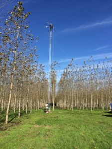
US-Wpp
The photo shows the eddy covariance tower at a hybrid poplar plantation where fluxes are measured since fall 2014.
Keywords: Hybrid poplar plantation
Location: Oregon, United States
View in Original Size
To download, right-click photo (Mac: control-click) and choose Save Image As
US-Wpp: Willamette Poplar
- Overview
- Windroses
- Data Citation
- Data Use Log
- Image Gallery
- Remote Sensing Data
- MODIS
- PhenoCam
- GeoNEX
- Publications
- BADM
MODIS NDVI
The time series shows the 16-day Normalized Difference Vegetation Index (NDVI) average from the MOD13Q1 data product.
Use the slider below the time series to zoom in and out.
To view / download these data and other MOD13Q1 products for this site, visit MODIS/Terra Vegetation Indices.
For other related products, visit MODIS/VIIRS Fixed Sites Subsets Tool.
Citation:
ORNL DAAC. 2018. Terrestrial Ecology Subsetting & Visualization Services (TESViS) Fixed Sites Subsets. ORNL DAAC, Oak Ridge, Tennessee, USA. https://doi.org/10.3334/ORNLDAAC/1567
MODIS NDVI subsetted data is not yet available for this site.
For a complete list of AmeriFlux sites, visit ORNL DAAC's MODIS/VIIRS Fixed Sites Subsets Tool.
PhenoCam Images and Derived Time Series Data
PhenoCams are high-resolution digital cameras that take repeated images of studied ecosystems and provide quantitative information about the canopy phenology. The PhenoCam Network coordinates the camera installation and data reporting/analyses across sites in the Americas, providing automated, near-surface remote sensing of canopy phenology across a range of ecosystems and climate zones. Use of PhenoCam images / data should follow the PhenoCam Data Use Policy .
PhenoCam sites for US-Wpp:
Use the links below to explore camera images and interactive timeseries for these sites.
Citation:
B. Seyednasrollah, A. M. Young, K. Hufkens, T. Milliman, M. A. Friedl, S. Frolking, and A. D. Richardson. Tracking vegetation phenology across diverse biomes using version 2.0 of the phenocam dataset. Scientific Data, 6(1):222, 2019. doi:10.1038/s41597-019-0229-9Camera Imagery
Milliman, T., B. Seyednasrollah, A.M. Young, K. Hufkens, M.A. Friedl, S. Frolking, A.D. Richardson, M. Abraha, D.W. Allen, M. Apple, M.A. Arain, J.M. Baker, D. Baldocchi, C.J. Bernacchi, J. Bhattacharjee, P. Blanken, D.D. Bosch, R. Boughton, E.H. Boughton, R.F. Brown, D.M. Browning, N. Brunsell, S.P. Burns, M. Cavagna, H. Chu, P.E. Clark, B.J. Conrad, E. Cremonese, D. Debinski, A.R. Desai, R. Diaz-Delgado, L. Duchesne, A.L. Dunn, D.M. Eissenstat, T. El-Madany, D.S.S. Ellum, S.M. Ernest, A. Esposito, L. Fenstermaker, L.B. Flanagan, B. Forsythe, J. Gallagher, D. Gianelle, T. Griffis, P. Groffman, L. Gu, J. Guillemot, M. Halpin, P.J. Hanson, D. Hemming, A.A. Hove, E.R. Humphreys, A. Jaimes-Hernandez, A.A. Jaradat, J. Johnson, E. Keel, V.R. Kelly, J.W. Kirchner, P.B. Kirchner, M. Knapp, M. Krassovski, O. Langvall, G. Lanthier, G.l. Maire, E. Magliulo, T.A. Martin, B. McNeil, G.A. Meyer, M. Migliavacca, B.P. Mohanty, C.E. Moore, R. Mudd, J.W. Munger, Z.E. Murrell, Z. Nesic, H.S. Neufeld, W. Oechel, A.C. Oishi, W.W. Oswald, T.D. Perkins, M.L. Reba, B. Rundquist, B.R. Runkle, E.S. Russell, E.J. Sadler, A. Saha, N.Z. Saliendra, L. Schmalbeck, M.D. Schwartz, R.L. Scott, E.M. Smith, O. Sonnentag, P. Stoy, S. Strachan, K. Suvocarev, J.E. Thom, R.Q. Thomas, A.K. Van den berg, R. Vargas, J. Verfaillie, C.S. Vogel, J.J. Walker, N. Webb, P. Wetzel, S. Weyers, A.V. Whipple, T.G. Whitham, G. Wohlfahrt, J.D. Wood, J. Yang, X. Yang, G. Yenni, Y. Zhang, Q. Zhang, and D. Zona. 2019. PhenoCam Dataset v2.0: Digital Camera Imagery from the PhenoCam Network, 2000-2018. ORNL DAAC, Oak Ridge, Tennessee, USA. https://doi.org/10.3334/ORNLDAAC/1689
Green Chromatic Coordinate Time Series
Seyednasrollah, B., A.M. Young, K. Hufkens, T. Milliman, M.A. Friedl, S. Frolking, A.D. Richardson, M. Abraha, D.W. Allen, M. Apple, M.A. Arain, J. Baker, J.M. Baker, D. Baldocchi, C.J. Bernacchi, J. Bhattacharjee, P. Blanken, D.D. Bosch, R. Boughton, E.H. Boughton, R.F. Brown, D.M. Browning, N. Brunsell, S.P. Burns, M. Cavagna, H. Chu, P.E. Clark, B.J. Conrad, E. Cremonese, D. Debinski, A.R. Desai, R. Diaz-Delgado, L. Duchesne, A.L. Dunn, D.M. Eissenstat, T. El-Madany, D.S.S. Ellum, S.M. Ernest, A. Esposito, L. Fenstermaker, L.B. Flanagan, B. Forsythe, J. Gallagher, D. Gianelle, T. Griffis, P. Groffman, L. Gu, J. Guillemot, M. Halpin, P.J. Hanson, D. Hemming, A.A. Hove, E.R. Humphreys, A. Jaimes-Hernandez, A.A. Jaradat, J. Johnson, E. Keel, V.R. Kelly, J.W. Kirchner, P.B. Kirchner, M. Knapp, M. Krassovski, O. Langvall, G. Lanthier, G.l. Maire, E. Magliulo, T.A. Martin, B. McNeil, G.A. Meyer, M. Migliavacca, B.P. Mohanty, C.E. Moore, R. Mudd, J.W. Munger, Z.E. Murrell, Z. Nesic, H.S. Neufeld, T.L. O'Halloran, W. Oechel, A.C. Oishi, W.W. Oswald, T.D. Perkins, M.L. Reba, B. Rundquist, B.R. Runkle, E.S. Russell, E.J. Sadler, A. Saha, N.Z. Saliendra, L. Schmalbeck, M.D. Schwartz, R.L. Scott, E.M. Smith, O. Sonnentag, P. Stoy, S. Strachan, K. Suvocarev, J.E. Thom, R.Q. Thomas, A.K. Van den berg, R. Vargas, J. Verfaillie, C.S. Vogel, J.J. Walker, N. Webb, P. Wetzel, S. Weyers, A.V. Whipple, T.G. Whitham, G. Wohlfahrt, J.D. Wood, S. Wolf, J. Yang, X. Yang, G. Yenni, Y. Zhang, Q. Zhang, and D. Zona. 2019. PhenoCam Dataset v2.0: Vegetation Phenology from Digital Camera Imagery, 2000-2018. ORNL DAAC, Oak Ridge, Tennessee, USA. https://doi.org/10.3334/ORNLDAAC/1674
GeoNEX Data Products
GeoNEX led by NASA Earth eXchange (NEX) is a collaborative effort for generating Earth monitoring products from the new generation of geostationary satellite sensors. GeoNEX has produced a suite of geostationary data products including surface reflectance, land surface temperature, surface solar radiation, and many others.
The GeoNEX Common Grid locates GeoNEX data in the geographic (latitude/longitude) projection. Pixels (grid cells) are created at regular 0.005°, 0.01°, and 0.02° resolutions.
GeoNEX pixels below cover the area 0.06° x 0.06° around and including site US-Wpp, 44.1369, -123.1824.
Click a square in the grid at left to display its data below.
Coordinates for selected GeoNEX Pixel
Graph controls:
- Zoom: click-drag
- Pan: shift-click-drag
- Restore zoom level: double-click
- Use the slider below the time series to zoom in and out.
All download requests will be logged.
NDVI: Normalized Difference Vegetation Index
Resolution: 0.01° x 0.01° & 10 minutes
Coordinates for pixel:
NIRv Near-Infrared Reflectance of vegetation
Resolution: 0.01° x 0.01° & 10 minutes
Coordinates for pixel:
DSR: Surface downward shortwave radiation
Resolution: 0.01° x 0.01° & Hourly
Coordinates for pixel:
LST: Land Surface Temperature
Resolution: 0.02° x 0.02° & Hourly
Coordinates for pixel:
Citation
This material can be used without obtaining permission from NASA. NASA should be acknowledged as the source of this material.
Subset Data Citation:
- Hashimoto, H., Wang, W., Park, T., Khajehei, S., Ichii, K., Michaelis, A.R., Guzman, A., Nemani, R.R., Torn, M., Yi, K., Brosnan, I.G. (in preparation). Subsets of geostationary satellite data over international observing network sites for studying the diurnal dynamics of energy, carbon, and water cycles.
Relevant Science Publication Citation:
GeoNEX Surface Reflectance for Vegetation Indices (NDVI & NIRv)- Wang, W., Wang, Y., Lyapustin, A., Hashimoto, H., Park, T., Michaelis, A., & Nemani, R. (2022). A novel atmospheric correction algorithm to exploit the diurnal variability in hypertemporal geostationary observations. Remote Sensing, 14(4), 964.
- Li, R., Wang, D., Wang, W., & Nemani, R. (2023). A GeoNEX-based high-spatiotemporal-resolution product of land surface downward shortwave radiation and photosynthetically active radiation. Earth System Science Data, 15(3), 1419-1436.
- Jia, A., Liang, S., & Wang, D. (2022). Generating a 2-km, all-sky, hourly land surface temperature product from Advanced Baseline Imager data. Remote Sensing of Environment, 278, 113105.
US-Wpp: Willamette Poplar
- Overview
- Windroses
- Data Citation
- Data Use Log
- Image Gallery
- Remote Sensing Data
- MODIS
- PhenoCam
- GeoNEX
- Publications
- BADM
AmeriFlux Publications | Add Publication |
Year | Publication |
---|---|
2021 | Chu, H., Luo, X., Ouyang, Z., Chan, W. S., Dengel, S., Biraud, S. C., Torn, M. S., Metzger, S., Kumar, J., Arain, M. A., Arkebauer, T. J., Baldocchi, D., Bernacchi, C., Billesbach, D., Black, T. A., Blanken, P. D., Bohrer, G., Bracho, R., Brown, S., Brunsell, N. A., Chen, J., Chen, X., Clark, K., Desai, A. R., Duman, T., Durden, D., Fares, S., Forbrich, I., Gamon, J. A., Gough, C. M., Griffis, T., Helbig, M., Hollinger, D., Humphreys, E., Ikawa, H., Iwata, H., Ju, Y., Knowles, J. F., Knox, S. H., Kobayashi, H., Kolb, T., Law, B., Lee, X., Litvak, M., Liu, H., Munger, J. W., Noormets, A., Novick, K., Oberbauer, S. F., Oechel, W., Oikawa, P., Papuga, S. A., Pendall, E., Prajapati, P., Prueger, J., Quinton, W. L., Richardson, A. D., Russell, E. S., Scott, R. L., Starr, G., Staebler, R., Stoy, P. C., Stuart-Haëntjens, E., Sonnentag, O., Sullivan, R. C., Suyker, A., Ueyama, M., Vargas, R., Wood, J. D., Zona, D. (2021) Representativeness Of Eddy-Covariance Flux Footprints For Areas Surrounding Ameriflux Sites, Agricultural And Forest Meteorology, 301-302, 108350. https://doi.org/10.1016/j.agrformet.2021.108350 |
US-Wpp: Willamette Poplar
- Overview
- Windroses
- Data Citation
- Data Use Log
- Image Gallery
- Remote Sensing Data
- MODIS
- PhenoCam
- GeoNEX
- Publications
- BADM
BADM for This Site
Access the Biological, Ancillary, Disturbance and Metadata (BADM) information and data for this site.
BADM contain information for many uses, such as characterizing a site’s vegetation and soil, describing disturbance history, and defining instrumentation for flux processing. They complement the flux/met data.
- Download BADM for this site*
- View Site General Info for this site (Overview tab)*
- Use Online Editor to update Site General Info or DOI Authorship
- Update information about submitted data (Variable Information tool)
- More BADM resources
* Online updates are shown on the Overview tab real time. However, downloaded BADM files will not reflect those updates until they have been reviewed for QA/QC.
US-Wpp: Willamette Poplar
- Overview
- Windroses
- Data Citation
- Data Use Log
- Image Gallery
- Remote Sensing Data
- MODIS
- PhenoCam
- GeoNEX
- Publications
- BADM
Wind Roses
Wind Speed (m/s)
Navigation
- Wind Speed Scale: Per Site
- Wind Direction Scale (%): Per Site
- Wind Speed Scale: Non-Linear
- Wind Direction Scale (%): AmeriFlux