
US-VT2: Vermillion Tributary Paired Cropland – Site 2 (Corn/Soy; Cover Crops)
- Overview
- Windroses
- Data Citation
- Data Use Log
- Image Gallery
- Remote Sensing Data
- MODIS
- PhenoCam
- GeoNEX
- Publications
- BADM
| Tower_team: | |
| PI: | Kesondra Key keyke@iu.edu - Indiana University - Bloomington |
| PI: | Kim Novick knovick@iu.edu - Indiana University - Bloomington |
| Technician: | Michael Voyles mpvoyles@iu.edu - Indiana University - Bloomington |
| Technician: | Steve Scott stlscott@indiana.edu - Indiana University - Bloomington |
| Technician: | Trevor Gress trgress@iu.edu - Indiana University - Bloomington |
| Lat, Long: | 40.4018, -87.5213 |
| Elevation(m): | 216 |
| Network Affiliations: | AmeriFlux |
| Vegetation IGBP: | CRO (Croplands: Lands covered with temporary crops followed by harvest and a bare soil period (e.g., single and multiple cropping systems). Note that perennial woody crops will be classified as the appropriate forest or shrub land cover type.) |
| Climate Koeppen: | Cfa (Humid Subtropical: mild with no dry season, hot summer) |
| Mean Annual Temp (°C): | 11.37 |
| Mean Annual Precip. (mm): | 1068.37 |
| Flux Species Measured: | CO2, H, H2O |
| Years Data Collected: | 2023 - Present |
| Years Data Available: | AmeriFlux BASE 2023 - 2025 Data Citation AmeriFlux FLUXNET 2023 - 2025 Data Citation |
| Data Use Policy: | AmeriFlux CC-BY-4.0 Policy1 |
| Description: | |
| URL: | https://kesondrakey.github.io/ |
| Research Topics: | |
| Acknowledgment: | Ameriflux Project; NSF |
- This site’s data can also be used under the more restrictive AmeriFlux Legacy Policy.
The AmeriFlux Legacy Policy must be followed if this site’s data are combined with data from sites that require the AmeriFlux Legacy Policy.
Copyright preference: As long as credit is given
US-VT2: Vermillion Tributary Paired Cropland – Site 2 (Corn/Soy; Cover Crops)
- Overview
- Windroses
- Data Citation
- Data Use Log
- Image Gallery
- Remote Sensing Data
- MODIS
- PhenoCam
- GeoNEX
- Publications
- BADM
Use the information below for citation of this site. See the Data Policy page for more details.
DOI(s) for citing US-VT2 data
Data Use Policy: AmeriFlux CC-BY-4.0 License
This site’s data can also be used under the more restrictive AmeriFlux Legacy Policy.
The AmeriFlux Legacy Policy must be followed if US-VT2 data are combined with data from sites that require the AmeriFlux Legacy Policy.
- AmeriFlux BASE: https://doi.org/10.17190/AMF/2567995
Citation: Kesondra Key, Kim Novick (2025), AmeriFlux BASE US-VT2 Vermillion Tributary Paired Cropland – Site 2 (Corn/Soy; Cover Crops), Ver. 3-5, AmeriFlux AMP, (Dataset). https://doi.org/10.17190/AMF/2567995 - AmeriFlux FLUXNET: https://doi.org/10.17190/AMF/3027370
Citation: Kesondra Key, Kim Novick (2026), AmeriFlux FLUXNET-1F US-VT2 Vermillion Tributary Paired Cropland – Site 2 (Corn/Soy; Cover Crops), Ver. v1.3_r1, AmeriFlux AMP, (Dataset). https://doi.org/10.17190/AMF/3027370
Find global FLUXNET datasets, like FLUXNET2015 and FLUXNET-CH4, and their citation information at fluxnet.org.
To cite BADM when downloaded on their own, use the publications below for citing site characterization. When using BADM that are downloaded with AmeriFlux BASE and AmeriFlux FLUXNET products, use the DOI citation for the associated data product.
Publication(s) for citing site characterization
- —
Acknowledgments
- —
Resources
- AmeriFlux Logos & Acknowledgments
US-VT2: Vermillion Tributary Paired Cropland – Site 2 (Corn/Soy; Cover Crops)
- Overview
- Windroses
- Data Citation
- Data Use Log
- Image Gallery
- Remote Sensing Data
- MODIS
- PhenoCam
- GeoNEX
- Publications
- BADM

This page displays the list of downloads of data for the site {{siteId}}.
Note: Results are the number of downloads to distinct data users. The Download Count column indicates the number of times the data user downloaded the data. The Version column refers to the version of the data product for the site that was downloaded by the data user.
| Date | Name | Data Product | Vers. | Intended Use | Intended Use Description | Download Count |
|---|---|---|---|---|---|---|
| {{dlObject.timeStamp}} | {{dlObject.displayName}} | {{displayProduct(dlObject.dataProduct)}} | {{dlObject.version}} | {{dlObject.intendedUse}} | {{dlObject.comment}} | {{dlObject.downloadCounter}} |
Showing {{startItem + 1}} to {{(startItem + items) > filtered.length ? filtered.length : (startItem + items)}} of {{filtered.length}} results
Showing 0 to 0 of 0 results
Not Found
Uh Oh. Something is missing. Try double checking the URL and try again.
US-VT2: Vermillion Tributary Paired Cropland – Site 2 (Corn/Soy; Cover Crops)
- Overview
- Windroses
- Data Citation
- Data Use Log
- Image Gallery
- Remote Sensing Data
- MODIS
- PhenoCam
- GeoNEX
- Publications
- BADM
| AmeriFlux Images | Add Image |
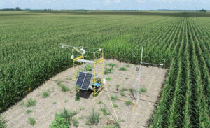
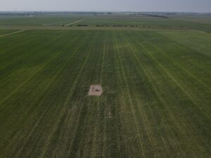 US-VT2
 US-VT2 – June 2023
Image taken with DJI drone by Steve Scott
Keywords: US-VT2
Location: Indiana, United States
View in Original Size
To download, right-click photo (Mac: control-click) and choose Save Image As
US-VT2 US-VT2 – August 2023
Photo taken by Steve Scott with a DJI Drone
Keywords: US-VT2
Location: Indiana, United States
View in Original Size
To download, right-click photo (Mac: control-click) and choose Save Image As
US-VT2: Vermillion Tributary Paired Cropland – Site 2 (Corn/Soy; Cover Crops)
- Overview
- Windroses
- Data Citation
- Data Use Log
- Image Gallery
- Remote Sensing Data
- MODIS
- PhenoCam
- GeoNEX
- Publications
- BADM
| AmeriFlux Publications | Add Publication |
US-VT2: Vermillion Tributary Paired Cropland – Site 2 (Corn/Soy; Cover Crops)
- Overview
- Windroses
- Data Citation
- Data Use Log
- Image Gallery
- Remote Sensing Data
- MODIS
- PhenoCam
- GeoNEX
- Publications
- BADM
BADM for This Site
Access the Biological, Ancillary, Disturbance and Metadata (BADM) information and data for this site.
BADM contain information for many uses, such as characterizing a site’s vegetation and soil, describing disturbance history, and defining instrumentation for flux processing. They complement the flux/met data.
- Download BADM for this site*
- View Site General Info for this site (Overview tab)*
- Use Online Editor to update Site General Info or DOI Authorship
- Update information about submitted data (Variable Information tool)
- More BADM resources
* Online updates are shown on the Overview tab real time. However, downloaded BADM files will not reflect those updates until they have been reviewed for QA/QC.
US-VT2: Vermillion Tributary Paired Cropland – Site 2 (Corn/Soy; Cover Crops)
- Overview
- Windroses
- Data Citation
- Data Use Log
- Image Gallery
- Remote Sensing Data
- MODIS
- PhenoCam
- GeoNEX
- Publications
- BADM