
US-MtB: Mt Bigelow
- Overview
- Windroses
- Data Citation
- Data Use Log
- Image Gallery
- Remote Sensing Data
- MODIS
- PhenoCam
- GeoNEX
- Publications
- BADM
| Tower_team: | |
| PI: | Greg Barron-Gafford gregbg@arizona.edu - University of Arizona |
| PI: | Russ Scott russ.scott@usda.gov - USDA ARS Southwest Watershed Research Center |
| AncContact: | John Knowles John.knowles@montana.edu - Montana State University |
| Lat, Long: | 32.4160, -110.7256 |
| Elevation(m): | 2573 |
| Network Affiliations: | AmeriFlux |
| Vegetation IGBP: | ENF (Evergreen Needleleaf Forests: Lands dominated by woody vegetation with a percent cover >60% and height exceeding 2 meters. Almost all trees remain green all year. Canopy is never without green foliage.) |
| Climate Koeppen: | Dwb (Warm Summer Continental: dry winters ) |
| Mean Annual Temp (°C): | 9.3 |
| Mean Annual Precip. (mm): | 790 |
| Flux Species Measured: | CO2, H2O |
| Years Data Collected: | 2009 - Present |
| Years Data Available: | AmeriFlux BASE 2009 - 2024 Data Citation AmeriFlux FLUXNET 2009 - 2024 Data Citation |
| Data Use Policy: | AmeriFlux CC-BY-4.0 Policy1 |
| Description: | |
| URL: | https://www.barrongafford.org/montane-ecosystem--the-critical-zone.html |
| Research Topics: | Ecohydrology |
| Acknowledgment: | Funding for the Mt. Bigelow operation and maintenance was provided by National Science Foundation EAR awards 0724958 and 1331408 to the Catalina-Jemez Critical Zone Observatory. |
- This site’s data can also be used under the more restrictive AmeriFlux Legacy Policy.
The AmeriFlux Legacy Policy must be followed if this site’s data are combined with data from sites that require the AmeriFlux Legacy Policy.
Copyright preference: As long as credit is given
US-MtB: Mt Bigelow
- Overview
- Windroses
- Data Citation
- Data Use Log
- Image Gallery
- Remote Sensing Data
- MODIS
- PhenoCam
- GeoNEX
- Publications
- BADM
Use the information below for citation of this site. See the Data Policy page for more details.
DOI(s) for citing US-MtB data
Data Use Policy: AmeriFlux CC-BY-4.0 License
This site’s data can also be used under the more restrictive AmeriFlux Legacy Policy.
The AmeriFlux Legacy Policy must be followed if US-MtB data are combined with data from sites that require the AmeriFlux Legacy Policy.
- AmeriFlux BASE: https://doi.org/10.17190/AMF/1579717
Citation: Greg Barron-Gafford (2025), AmeriFlux BASE US-MtB Mt Bigelow, Ver. 5-5, AmeriFlux AMP, (Dataset). https://doi.org/10.17190/AMF/1579717 - AmeriFlux FLUXNET: https://doi.org/10.17190/AMF/2571103
Citation: Greg Barron-Gafford (2025), AmeriFlux FLUXNET-1F US-MtB Mt Bigelow, Ver. 3-7, AmeriFlux AMP, (Dataset). https://doi.org/10.17190/AMF/2571103
Find global FLUXNET datasets, like FLUXNET2015 and FLUXNET-CH4, and their citation information at fluxnet.org.
To cite BADM when downloaded on their own, use the publications below for citing site characterization. When using BADM that are downloaded with AmeriFlux BASE and AmeriFlux FLUXNET products, use the DOI citation for the associated data product.
Publication(s) for citing site characterization
- —
Acknowledgments
- —
Resources
- AmeriFlux Logos & Acknowledgments
US-MtB: Mt Bigelow
- Overview
- Windroses
- Data Citation
- Data Use Log
- Image Gallery
- Remote Sensing Data
- MODIS
- PhenoCam
- GeoNEX
- Publications
- BADM

This page displays the list of downloads of data for the site {{siteId}}.
Note: Results are the number of downloads to distinct data users. The Download Count column indicates the number of times the data user downloaded the data. The Version column refers to the version of the data product for the site that was downloaded by the data user.
| Date | Name | Data Product | Vers. | Intended Use | Intended Use Description | Download Count |
|---|---|---|---|---|---|---|
| {{dlObject.timeStamp}} | {{dlObject.displayName}} | {{displayProduct(dlObject.dataProduct)}} | {{dlObject.version}} | {{dlObject.intendedUse}} | {{dlObject.comment}} | {{dlObject.downloadCounter}} |
Showing {{startItem + 1}} to {{(startItem + items) > filtered.length ? filtered.length : (startItem + items)}} of {{filtered.length}} results
Showing 0 to 0 of 0 results
Not Found
Uh Oh. Something is missing. Try double checking the URL and try again.
US-MtB: Mt Bigelow
- Overview
- Windroses
- Data Citation
- Data Use Log
- Image Gallery
- Remote Sensing Data
- MODIS
- PhenoCam
- GeoNEX
- Publications
- BADM
| AmeriFlux Images | Add Image |
 US-MtB
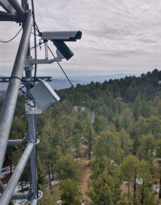
 Thermal Camera
William Smith and Mostafa Javadian installed an ICI thermal camera on the US-MtB tower to get continuous 10-min interval thermal images.
Keywords: Thermal, remote-sensing, US-MtB
Location:
View in Original Size
To download, right-click photo (Mac: control-click) and choose Save Image As
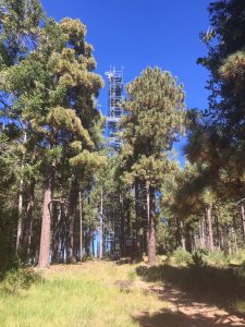
US-MtB Tower_Bigelow
Keywords: —
Location:
View in Original Size
To download, right-click photo (Mac: control-click) and choose Save Image As
 US-MtB
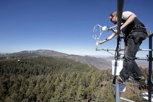
 Greg_Bigelow
Keywords: —
Location: Arizona, United States
View in Original Size
To download, right-click photo (Mac: control-click) and choose Save Image As
US-MtB: Mt Bigelow
- Overview
- Windroses
- Data Citation
- Data Use Log
- Image Gallery
- Remote Sensing Data
- MODIS
- PhenoCam
- GeoNEX
- Publications
- BADM
| AmeriFlux Publications | Add Publication |
| Year | Publication |
|---|---|
| 2024 | Webb, R., Knowles, J., Fox, A., Fabricus, A., Corrie, T., Mooney, K., Gallais, J., Frimpong, N., Akurugu, C., Barron‐Gafford, G., Blanken, P., Burns, S., Frank, J., Litvak, M. (2024) Energy‐Water Asynchrony Principally Determines Water Available For Runoff From Snowmelt In Continental Montane Forests, Hydrological Processes, 38(10), . https://doi.org/10.1002/hyp.15297 |
| 2024 | Javadian, M., Scott, R. L., Woodgate, W., Richardson, A. D., Dannenberg, M. P., Smith, W. K. (2024) Canopy temperature dynamics are closely aligned with ecosystem water availability across a water- to energy-limited gradient, Agricultural And Forest Meteorology, 357, 110206. https://doi.org/https://doi.org/10.1016/j.agrformet.2024.110206 |
| 2022 | Javadian, M., Smith, W. K., Lee, K., Knowles, J. F., Scott, R. L., Fisher, J. B., Moore, D. J., Leeuwen, W. J., Barron‐Gafford, G., Behrangi, A. (2022) Canopy Temperature Is Regulated By Ecosystem Structural Traits And Captures The Ecohydrologic Dynamics Of A Semiarid Mixed Conifer Forest Site, Journal Of Geophysical Research: Biogeosciences, 127(2), e2021JG006617. https://doi.org/10.1029/2021JG006617 |
| 2021 | Chu, H., Luo, X., Ouyang, Z., Chan, W. S., Dengel, S., Biraud, S. C., Torn, M. S., Metzger, S., Kumar, J., Arain, M. A., Arkebauer, T. J., Baldocchi, D., Bernacchi, C., Billesbach, D., Black, T. A., Blanken, P. D., Bohrer, G., Bracho, R., Brown, S., Brunsell, N. A., Chen, J., Chen, X., Clark, K., Desai, A. R., Duman, T., Durden, D., Fares, S., Forbrich, I., Gamon, J. A., Gough, C. M., Griffis, T., Helbig, M., Hollinger, D., Humphreys, E., Ikawa, H., Iwata, H., Ju, Y., Knowles, J. F., Knox, S. H., Kobayashi, H., Kolb, T., Law, B., Lee, X., Litvak, M., Liu, H., Munger, J. W., Noormets, A., Novick, K., Oberbauer, S. F., Oechel, W., Oikawa, P., Papuga, S. A., Pendall, E., Prajapati, P., Prueger, J., Quinton, W. L., Richardson, A. D., Russell, E. S., Scott, R. L., Starr, G., Staebler, R., Stoy, P. C., Stuart-Haëntjens, E., Sonnentag, O., Sullivan, R. C., Suyker, A., Ueyama, M., Vargas, R., Wood, J. D., Zona, D. (2021) Representativeness Of Eddy-Covariance Flux Footprints For Areas Surrounding Ameriflux Sites, Agricultural And Forest Meteorology, 301-302, 108350. https://doi.org/10.1016/j.agrformet.2021.108350 |
| 2021 | Dwivedi, R., Eastoe, C., Knowles, J. F., Hamann, L., Meixner, T., Ferre, P.A., Castro, C., Wright, W.E., Niu, G.-Y., Minor, R., Barron-Gafford, G. A., Abramson, N., Mitra, B., Papuga, S.A., Stanley, M., Chorover, J. (2021) An improved practical approach for estimating catchment‐scale response functions through wavelet analysis, Hydrological Processes, 35(3), e14082. https://doi.org/10.1002/hyp.14082 |
| 2020 | Murphy, P. C., Knowles, J. F., Moore, D. J. P., Anchukaitis, K., Potts, D. L., Barron-Gafford, G. A. (2020) Topography Influences Species-Specific Patterns Of Seasonal Primary Productivity In A Semiarid Montane Forest, Tree Physiology, 40(10), 1343-1354. https://doi.org/10.1093/treephys/tpaa083 |
| 2020 | Yang, J. C., Magney, T. S., Yan, D., Knowles, J. F., Smith, W. K., Scott, R. L., Barron‐Gafford, G. A. (2020) The Photochemical Reflectance Index (Pri) Captures The Ecohydrologic Sensitivity Of A Semiarid Mixed Conifer Forest, Journal Of Geophysical Research: Biogeosciences, 125(11), . https://doi.org/10.1029/2019JG005624 |
| 2020 | Knowles, J. F., Scott, R. L., Biederman, J. A., Blanken, P. D., Burns, S. P., Dore, S., Kolb, T. E., Litvak, M. E., Barron‐Gafford, G. A. (2020) Montane Forest Productivity Across A Semiarid Climatic Gradient, Global Change Biology, 26(12), 6945-6958. https://doi.org/10.1111/gcb.15335 |
| 2019 | Dwivedi, R., Eastoe, C., Knowles, J. F., Wright, W. E., Hamann, L., Minor, R., Mitra, B., Meixner, T., McIntosh, J., Ty Ferre, P. A., Castro, C., Niu, G., Barron‐Gafford, G. A., Abramson, N., Papuga, S. A., Stanley, M., Hu, J., Chorover, J. (2019) Vegetation Source Water Identification Using Isotopic And Hydrometric Observations From A Subhumid Mountain Catchment, Ecohydrology, 13, . https://doi.org/10.1002/eco.2167 |
| 2019 | Olshansky, Y., Knowles, J. F., Barron‐Gafford, G. A., Rasmussen, C., Abramson, N., Chorover, J. (2019) Soil Fluid Biogeochemical Response To Climatic Events, Journal Of Geophysical Research: Biogeosciences, 124(9), 2866-2882. https://doi.org/10.1029/2019JG005216 |
| 2018 | Chang, L., Dwivedi, R., Knowles, J. F., Fang, Y., Niu, G., Pelletier, J. D., Rasmussen, C., Durcik, M., Barron-Gafford, G. A., Meixner, T. (2018) Why Do Large-Scale Land Surface Models Produce A Low Ratio Of Transpiration To Evapotranspiration?, Journal Of Geophysical Research: Atmospheres, 123(17), 9109-9130. https://doi.org/10.1029/2018JD029159 |
| 2020 | Knowles, J. F., Scott, R. L., Minor, R. L., Barron-Gafford, G. A. (2020) Ecosystem Carbon And Water Cycling From A Sky Island Montane Forest, Agricultural And Forest Meteorology, 281, 107835. https://doi.org/10.1016/j.agrformet.2019.107835 |
US-MtB: Mt Bigelow
- Overview
- Windroses
- Data Citation
- Data Use Log
- Image Gallery
- Remote Sensing Data
- MODIS
- PhenoCam
- GeoNEX
- Publications
- BADM
BADM for This Site
Access the Biological, Ancillary, Disturbance and Metadata (BADM) information and data for this site.
BADM contain information for many uses, such as characterizing a site’s vegetation and soil, describing disturbance history, and defining instrumentation for flux processing. They complement the flux/met data.
- Download BADM for this site*
- View Site General Info for this site (Overview tab)*
- Use Online Editor to update Site General Info or DOI Authorship
- Update information about submitted data (Variable Information tool)
- More BADM resources
* Online updates are shown on the Overview tab real time. However, downloaded BADM files will not reflect those updates until they have been reviewed for QA/QC.
US-MtB: Mt Bigelow
- Overview
- Windroses
- Data Citation
- Data Use Log
- Image Gallery
- Remote Sensing Data
- MODIS
- PhenoCam
- GeoNEX
- Publications
- BADM
Wind Roses
Wind Speed (m/s)
- Wind Speed Scale: Per Site
- Wind Direction Scale (%): Per Site
- Wind Speed Scale: Non-Linear
- Wind Direction Scale (%): AmeriFlux