US-Jo3: Jornada Experimental Range Red Lake Playa
- Overview
- Windroses
- Data Citation
- Data Use Log
- Image Gallery
- Remote Sensing Data
- MODIS
- PhenoCam
- GeoNEX
- Publications
- BADM
Tower_team: | |
PI: | Marguerite Mauritz memauritz@utep.edu - The University of Texas at El Paso |
AncContact: | Anthony Darrouzet-Nardi ajdarrouzetnardi@utep.edu - |
DataManager: | Gesuri Ramirez gramirez12@utep.edu - |
Lat, Long: | 32.7123, -106.8303 |
Elevation(m): | — |
Network Affiliations: | AmeriFlux, CZNet, LTER |
Vegetation IGBP: | BSV (Barren Sparse Vegetation: Lands exposed soil, sand, or rocks and has less than 10% vegetative cover during any time of the year.) |
Climate Koeppen: | Bwk (Desert: very cold winter) |
Mean Annual Temp (°C): | 14.7 |
Mean Annual Precip. (mm): | 245.1 |
Flux Species Measured: | CO2, H, H2O |
Years Data Collected: | 2021 - Present |
Years Data Available: | No data available |
Data Use Policy: | AmeriFlux CC-BY-4.0 Policy1 |
Description: | The Jornada Basin Experimental Range (JER) covers 783km2 in the La Jornada del Muerto plain of the Northen Chihuhua Desert and is located 20km of Las Cruses, ... The Jornada Basin Experimental Range (JER) covers 783km2 in the La Jornada del Muerto plain of the Northen Chihuhua Desert and is located 20km of Las Cruses, NM. The region has witnessed extensive grazing of livestocks, which is coincidental with large-scale grassland detoriation and transition to shrubland begining in the 1800s. The JER was established in 1912 to investigate the rangeland changes and has since become the central location for understanding dryland ecology. The flux tower monitors CO2 and H2O dynamics in Red Lake Playa, a large playa in the watershed of the San Andreas Mountain. Wetlands such as prairie potholes, vernal pools, and playas are both ecologically and economically important systems in North America. Playas are ephemerically flooded, depositional landforms located in topographic low areas of hydrologically closed dryland catchments. There are two main types of Playas, as defined by their primary source of floodwater:(a) Surface water and (b) groundwater playas. Surface water playas, such as Red Lake Playa, are flooded through precipitation and surface run-on from upland areas of their catchment and have the potential to be areas of groundwater recharge. The key concept of understanding how nutrients and water redistribution processes control the ecological functioning of drylands is the connectivity of ecosystem patches. Winds and water driven erosional or depositional processes occur at multiple scales in dryalnds, to shape a mosaic of high and low vegetation cover patches. These patches serve as sinks and sources of organic matter, soil particles, and plant propagules. The differential abiotic and biotic structure of these patches affects community structure and the functioning of ecosystems. In closed basin systems, surface water runoffs from uplands can lead to gains for lowland ecoystems like playas and potentially influence biogeochemical processes such as primary productivity. See MoreShow Less |
URL: | https://www.drylandcz.org/ |
Research Topics: | dryland carbon dynamics, dryland ephemeral lakes (playa), playa hydrology |
Acknowledgment: | — |
- This site’s data can also be used under the more restrictive AmeriFlux Legacy Policy.
The AmeriFlux Legacy Policy must be followed if this site’s data are combined with data from sites that require the AmeriFlux Legacy Policy.


Copyright preference: As long as credit is given
US-Jo3: Jornada Experimental Range Red Lake Playa
- Overview
- Windroses
- Data Citation
- Data Use Log
- Image Gallery
- Remote Sensing Data
- MODIS
- PhenoCam
- GeoNEX
- Publications
- BADM
Use the information below for citation of this site. See the Data Policy page for more details.
DOI(s) for citing US-Jo3 data
Data Use Policy: AmeriFlux CC-BY-4.0 License
- No DOIs available for US-Jo3
To cite BADM downloaded as a BIF file, use the publications listed below.
Publication(s) for citing site characterization
- —
Acknowledgments
- —
Resources
- AmeriFlux Logos & Acknowledgments
US-Jo3: Jornada Experimental Range Red Lake Playa
- Overview
- Windroses
- Data Citation
- Data Use Log
- Image Gallery
- Remote Sensing Data
- MODIS
- PhenoCam
- GeoNEX
- Publications
- BADM

This page displays the list of downloads of data for the site US-Jo3.
Note: Results are the number of downloads to distinct data users. The Download Count column indicates the number of times the data user downloaded the data. The Version column refers to the version of the data product for the site that was downloaded by the data user.
Date | Name | Data Product | Version | Intended Use | Intended Use Description | Download Count |
---|
Date | Name | Data Product | Vers. | Intended Use | Intended Use Description | Download Count |
---|---|---|---|---|---|---|
Showing 0 to 0 of 0 results
Not Found
Uh Oh. Something is missing. Try double checking the URL and try again.
US-Jo3: Jornada Experimental Range Red Lake Playa
- Overview
- Windroses
- Data Citation
- Data Use Log
- Image Gallery
- Remote Sensing Data
- MODIS
- PhenoCam
- GeoNEX
- Publications
- BADM
AmeriFlux Images | Add Image |
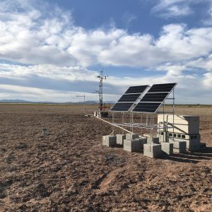
Red Lake Playa
Site View with Tower and Solar Panels
Keywords: —
Location: New Mexico, United States
View in Original Size
To download, right-click photo (Mac: control-click) and choose Save Image As
US-Jo3: Jornada Experimental Range Red Lake Playa
- Overview
- Windroses
- Data Citation
- Data Use Log
- Image Gallery
- Remote Sensing Data
- MODIS
- PhenoCam
- GeoNEX
- Publications
- BADM
MODIS NDVI
The time series shows the 16-day Normalized Difference Vegetation Index (NDVI) average from the MOD13Q1 data product.
Use the slider below the time series to zoom in and out.
To view / download these data and other MOD13Q1 products for this site, visit MODIS/Terra Vegetation Indices.
For other related products, visit MODIS/VIIRS Fixed Sites Subsets Tool.
Citation:
ORNL DAAC. 2018. Terrestrial Ecology Subsetting & Visualization Services (TESViS) Fixed Sites Subsets. ORNL DAAC, Oak Ridge, Tennessee, USA. https://doi.org/10.3334/ORNLDAAC/1567
MODIS NDVI subsetted data is not yet available for this site.
For a complete list of AmeriFlux sites, visit ORNL DAAC's MODIS/VIIRS Fixed Sites Subsets Tool.
PhenoCam Images and Derived Time Series Data
PhenoCams are high-resolution digital cameras that take repeated images of studied ecosystems and provide quantitative information about the canopy phenology. The PhenoCam Network coordinates the camera installation and data reporting/analyses across sites in the Americas, providing automated, near-surface remote sensing of canopy phenology across a range of ecosystems and climate zones. Use of PhenoCam images / data should follow the PhenoCam Data Use Policy .
No PhenoCam data for this siteGeoNEX Data Products
GeoNEX led by NASA Earth eXchange (NEX) is a collaborative effort for generating Earth monitoring products from the new generation of geostationary satellite sensors. GeoNEX has produced a suite of geostationary data products including surface reflectance, land surface temperature, surface solar radiation, and many others.
The GeoNEX Common Grid locates GeoNEX data in the geographic (latitude/longitude) projection. Pixels (grid cells) are created at regular 0.005°, 0.01°, and 0.02° resolutions.
GeoNEX pixels below cover the area 0.06° x 0.06° around and including site US-Jo3, 32.7123, -106.8303.
Click a square in the grid at left to display its data below.
Coordinates for selected GeoNEX Pixel
Lat: 32.7300 Long: -106.8600
US-Jo3
Graph controls:
- Zoom: click-drag
- Pan: shift-click-drag
- Restore zoom level: double-click
- Use the slider below the time series to zoom in and out.
All download requests will be logged.
NDVI: Normalized Difference Vegetation Index
Resolution: 0.01° x 0.01° & 10 minutes
Coordinates for pixel: Lat: 32.7300 Long: -106.8600
NIRv Near-Infrared Reflectance of vegetation
Resolution: 0.01° x 0.01° & 10 minutes
Coordinates for pixel: Lat: 32.7300 Long: -106.8600
DSR: Surface downward shortwave radiation
Resolution: 0.01° x 0.01° & Hourly
Coordinates for pixel: Lat: 32.7300 Long: -106.8600
LST: Land Surface Temperature
Resolution: 0.02° x 0.02° & Hourly
Coordinates for pixel: Lat: 32.7200 Long: -106.8600
Citation
This material can be used without obtaining permission from NASA. NASA should be acknowledged as the source of this material.
Subset Data Citation:
- Hashimoto, H., Wang, W., Park, T., Khajehei, S., Ichii, K., Michaelis, A.R., Guzman, A., Nemani, R.R., Torn, M., Yi, K., Brosnan, I.G. (in preparation). Subsets of geostationary satellite data over international observing network sites for studying the diurnal dynamics of energy, carbon, and water cycles.
Relevant Science Publication Citation:
GeoNEX Surface Reflectance for Vegetation Indices (NDVI & NIRv)- Wang, W., Wang, Y., Lyapustin, A., Hashimoto, H., Park, T., Michaelis, A., & Nemani, R. (2022). A novel atmospheric correction algorithm to exploit the diurnal variability in hypertemporal geostationary observations. Remote Sensing, 14(4), 964.
- Li, R., Wang, D., Wang, W., & Nemani, R. (2023). A GeoNEX-based high-spatiotemporal-resolution product of land surface downward shortwave radiation and photosynthetically active radiation. Earth System Science Data, 15(3), 1419-1436.
- Jia, A., Liang, S., & Wang, D. (2022). Generating a 2-km, all-sky, hourly land surface temperature product from Advanced Baseline Imager data. Remote Sensing of Environment, 278, 113105.
US-Jo3: Jornada Experimental Range Red Lake Playa
- Overview
- Windroses
- Data Citation
- Data Use Log
- Image Gallery
- Remote Sensing Data
- MODIS
- PhenoCam
- GeoNEX
- Publications
- BADM
AmeriFlux Publications | Add Publication |
US-Jo3: Jornada Experimental Range Red Lake Playa
- Overview
- Windroses
- Data Citation
- Data Use Log
- Image Gallery
- Remote Sensing Data
- MODIS
- PhenoCam
- GeoNEX
- Publications
- BADM
BADM for This Site
Access the Biological, Ancillary, Disturbance and Metadata (BADM) information and data for this site.
BADM contain information for many uses, such as characterizing a site’s vegetation and soil, describing disturbance history, and defining instrumentation for flux processing. They complement the flux/met data.
- Download BADM for this site*
- View Site General Info for this site (Overview tab)*
- Use Online Editor to update Site General Info or DOI Authorship
- Update information about submitted data (Variable Information tool)
- More BADM resources
* Online updates are shown on the Overview tab real time. However, downloaded BADM files will not reflect those updates until they have been reviewed for QA/QC.
US-Jo3: Jornada Experimental Range Red Lake Playa
- Overview
- Windroses
- Data Citation
- Data Use Log
- Image Gallery
- Remote Sensing Data
- MODIS
- PhenoCam
- GeoNEX
- Publications
- BADM