
US-Jo1: Jornada Experimental Range Bajada Site
- Overview
- Windroses
- Data Citation
- Data Use Log
- Image Gallery
- Remote Sensing Data
- MODIS
- PhenoCam
- GeoNEX
- Publications
- BADM
| Tower_team: | |
| PI: | Craig Tweedie ctweedie@utep.edu - University of Texas at El Paso (UTEP) |
| FluxContact: | Marguerite Mauritz memauritz@utep.edu - University of Texas at El Paso (UTEP) |
| DataManager: | Gesuri Ramirez gramirez12@utep.edu - University of Texas at El Paso (UTEP) |
| Lat, Long: | 32.5820, -106.6350 |
| Elevation(m): | 1188 |
| Network Affiliations: | AmeriFlux, LTER |
| Vegetation IGBP: | OSH (Open Shrublands: Lands with woody vegetation less than 2 meters tall and with shrub canopy cover between 10-60%. The shrub foliage can be either evergreen or deciduous.) |
| Climate Koeppen: | Bwk (Desert: very cold winter) |
| Mean Annual Temp (°C): | 14.7 |
| Mean Annual Precip. (mm): | 245.1 |
| Flux Species Measured: | CO2, H, H2O |
| Years Data Collected: | 2010 - Present |
| Years Data Available: | AmeriFlux BASE 2010 - 2022 Data Citation AmeriFlux FLUXNET 2010 - 2022 Data Citation |
| Data Use Policy: | AmeriFlux CC-BY-4.0 Policy1 |
| Description: | |
| URL: | https://selutep.squarespace.com |
| Research Topics: | Long-term ecosystem CO2, water, and energy balance monitoring |
| Acknowledgment: | — |
- This site’s data can also be used under the more restrictive AmeriFlux Legacy Policy.
The AmeriFlux Legacy Policy must be followed if this site’s data are combined with data from sites that require the AmeriFlux Legacy Policy.
Copyright preference: As long as credit is given
US-Jo1: Jornada Experimental Range Bajada Site
- Overview
- Windroses
- Data Citation
- Data Use Log
- Image Gallery
- Remote Sensing Data
- MODIS
- PhenoCam
- GeoNEX
- Publications
- BADM
Use the information below for citation of this site. See the Data Policy page for more details.
DOI(s) for citing US-Jo1 data
Data Use Policy: AmeriFlux CC-BY-4.0 License
This site’s data can also be used under the more restrictive AmeriFlux Legacy Policy.
The AmeriFlux Legacy Policy must be followed if US-Jo1 data are combined with data from sites that require the AmeriFlux Legacy Policy.
- AmeriFlux BASE: https://doi.org/10.17190/AMF/1767833
Citation: Craig Tweedie (2024), AmeriFlux BASE US-Jo1 Jornada Experimental Range Bajada Site, Ver. 4-5, AmeriFlux AMP, (Dataset). https://doi.org/10.17190/AMF/1767833 - AmeriFlux FLUXNET: https://doi.org/10.17190/AMF/1902833
Citation: Craig Tweedie (2026), AmeriFlux FLUXNET-1F US-Jo1 Jornada Experimental Range Bajada Site, Ver. v1.3_r1, AmeriFlux AMP, (Dataset). https://doi.org/10.17190/AMF/1902833
Find global FLUXNET datasets, like FLUXNET2015 and FLUXNET-CH4, and their citation information at fluxnet.org.
To cite BADM when downloaded on their own, use the publications below for citing site characterization. When using BADM that are downloaded with AmeriFlux BASE and AmeriFlux FLUXNET products, use the DOI citation for the associated data product.
Publication(s) for citing site characterization
- —
Acknowledgments
- —
Resources
- AmeriFlux Logos & Acknowledgments
US-Jo1: Jornada Experimental Range Bajada Site
- Overview
- Windroses
- Data Citation
- Data Use Log
- Image Gallery
- Remote Sensing Data
- MODIS
- PhenoCam
- GeoNEX
- Publications
- BADM

This page displays the list of downloads of data for the site {{siteId}}.
Note: Results are the number of downloads to distinct data users. The Download Count column indicates the number of times the data user downloaded the data. The Version column refers to the version of the data product for the site that was downloaded by the data user.
| Date | Name | Data Product | Vers. | Intended Use | Intended Use Description | Download Count |
|---|---|---|---|---|---|---|
| {{dlObject.timeStamp}} | {{dlObject.displayName}} | {{displayProduct(dlObject.dataProduct)}} | {{dlObject.version}} | {{dlObject.intendedUse}} | {{dlObject.comment}} | {{dlObject.downloadCounter}} |
Showing {{startItem + 1}} to {{(startItem + items) > filtered.length ? filtered.length : (startItem + items)}} of {{filtered.length}} results
Showing 0 to 0 of 0 results
Not Found
Uh Oh. Something is missing. Try double checking the URL and try again.
US-Jo1: Jornada Experimental Range Bajada Site
- Overview
- Windroses
- Data Citation
- Data Use Log
- Image Gallery
- Remote Sensing Data
- MODIS
- PhenoCam
- GeoNEX
- Publications
- BADM
| AmeriFlux Images | Add Image |
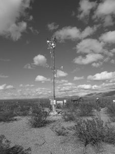
 US-Jo1
 View of Tower
View of the tower facing south west.
Keywords: —
Location: New Mexico, United States
View in Original Size
To download, right-click photo (Mac: control-click) and choose Save Image As
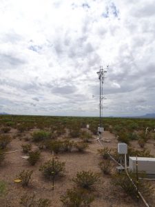
US-Jo1 Eddy Covariance at Jornada Experimental Range
This tower is run by the UTEP Systems Ecology Lab
Keywords: —
Location: Texas, United States
View in Original Size
To download, right-click photo (Mac: control-click) and choose Save Image As
US-Jo1: Jornada Experimental Range Bajada Site
- Overview
- Windroses
- Data Citation
- Data Use Log
- Image Gallery
- Remote Sensing Data
- MODIS
- PhenoCam
- GeoNEX
- Publications
- BADM
| AmeriFlux Publications | Add Publication |
| Year | Publication |
|---|---|
| 2025 | Xia, Y., Sanderman, J., Watts, J. D., Machmuller, M. B., Mullen, A. L., Rivard, C., Endsley, A., Hernandez, H., Kimball, J., Ewing, S. A., Litvak, M., Duman, T., Krishnan, P., Meyers, T., Brunsell, N. A., Mohanty, B., Liu, H., Gao, Z., Chen, J., Abraha, M., Scott, R. L., Flerchinger, G. N., Clark, P. E., Stoy, P. C., Khan, A. M., Brookshire, E. N., Zhang, Q., Cook, D. R., Thienelt, T., Mitra, B., Mauritz‐Tozer, M., Tweedie, C. E., Torn, M. S., Billesbach, D. (2025) Coupling Remote Sensing With A Process Model For The Simulation Of Rangeland Carbon Dynamics, Journal Of Advances In Modeling Earth Systems, 17(3), . https://doi.org/10.1029/2024MS004342 |
US-Jo1: Jornada Experimental Range Bajada Site
- Overview
- Windroses
- Data Citation
- Data Use Log
- Image Gallery
- Remote Sensing Data
- MODIS
- PhenoCam
- GeoNEX
- Publications
- BADM
BADM for This Site
Access the Biological, Ancillary, Disturbance and Metadata (BADM) information and data for this site.
BADM contain information for many uses, such as characterizing a site’s vegetation and soil, describing disturbance history, and defining instrumentation for flux processing. They complement the flux/met data.
- Download BADM for this site*
- View Site General Info for this site (Overview tab)*
- Use Online Editor to update Site General Info or DOI Authorship
- Update information about submitted data (Variable Information tool)
- More BADM resources
* Online updates are shown on the Overview tab real time. However, downloaded BADM files will not reflect those updates until they have been reviewed for QA/QC.
US-Jo1: Jornada Experimental Range Bajada Site
- Overview
- Windroses
- Data Citation
- Data Use Log
- Image Gallery
- Remote Sensing Data
- MODIS
- PhenoCam
- GeoNEX
- Publications
- BADM
Wind Roses
Wind Speed (m/s)
- Wind Speed Scale: Per Site
- Wind Direction Scale (%): Per Site
- Wind Speed Scale: Non-Linear
- Wind Direction Scale (%): AmeriFlux