
US-EA5: Uvalde Ranch Mesquite Woodland
- Overview
- Windroses
- Data Citation
- Data Use Log
- Image Gallery
- Remote Sensing Data
- MODIS
- PhenoCam
- GeoNEX
- Publications
- BADM
| Tower_team: | |
| PI: | Marcus Gary mgary@edwardsaquifer.org - Edwards Aquifer Authority |
| AncContact: | Michael Young michael.young@beg.utexas.edu - The University of Texas at Austin, Bureau of Economic Geology (UT-BEG) |
| Lat, Long: | 29.3584, -99.9576 |
| Elevation(m): | 322 |
| Network Affiliations: | AmeriFlux |
| Vegetation IGBP: | CSH (Closed Shrublands: Lands with woody vegetation less than 2 meters tall and with shrub canopy cover >60%. The shrub foliage can be either evergreen or deciduous.) |
| Climate Koeppen: | Cfa (Humid Subtropical: mild with no dry season, hot summer) |
| Mean Annual Temp (°C): | 20.9 |
| Mean Annual Precip. (mm): | 632 |
| Flux Species Measured: | CO2, H2O |
| Years Data Collected: | 2021 - 2023 |
| Years Data Available: | AmeriFlux BASE 2021 - 2023 Data Citation AmeriFlux FLUXNET 2021 - 2022 Data Citation |
| Data Use Policy: | AmeriFlux CC-BY-4.0 Policy1 |
| Description: | |
| URL: | — |
| Research Topics: | Flux data processing |
| Acknowledgment: | Supported by the Edwards Aquifer Authority (EAA), under Contract No. 20-041-AMS to UT-BEG |
- This site’s data can also be used under the more restrictive AmeriFlux Legacy Policy.
The AmeriFlux Legacy Policy must be followed if this site’s data are combined with data from sites that require the AmeriFlux Legacy Policy.
Copyright preference: Request for permission
US-EA5: Uvalde Ranch Mesquite Woodland
- Overview
- Windroses
- Data Citation
- Data Use Log
- Image Gallery
- Remote Sensing Data
- MODIS
- PhenoCam
- GeoNEX
- Publications
- BADM
Use the information below for citation of this site. See the Data Policy page for more details.
DOI(s) for citing US-EA5 data
Data Use Policy: AmeriFlux CC-BY-4.0 License
This site’s data can also be used under the more restrictive AmeriFlux Legacy Policy.
The AmeriFlux Legacy Policy must be followed if US-EA5 data are combined with data from sites that require the AmeriFlux Legacy Policy.
- AmeriFlux BASE: https://doi.org/10.17190/AMF/2204056
Citation: Tyson McKinney (2024), AmeriFlux BASE US-EA5 Uvalde Ranch Mesquite Woodland, Ver. 2-5, AmeriFlux AMP, (Dataset). https://doi.org/10.17190/AMF/2204056 - AmeriFlux FLUXNET: https://doi.org/10.17190/AMF/2571138
Citation: Tyson McKinney (2026), AmeriFlux FLUXNET-1F US-EA5 Uvalde Ranch Mesquite Woodland, Ver. v1.3_r1, AmeriFlux AMP, (Dataset). https://doi.org/10.17190/AMF/2571138
Find global FLUXNET datasets, like FLUXNET2015 and FLUXNET-CH4, and their citation information at fluxnet.org.
To cite BADM when downloaded on their own, use the publications below for citing site characterization. When using BADM that are downloaded with AmeriFlux BASE and AmeriFlux FLUXNET products, use the DOI citation for the associated data product.
Publication(s) for citing site characterization
- —
Acknowledgments
- —
Resources
- AmeriFlux Logos & Acknowledgments
US-EA5: Uvalde Ranch Mesquite Woodland
- Overview
- Windroses
- Data Citation
- Data Use Log
- Image Gallery
- Remote Sensing Data
- MODIS
- PhenoCam
- GeoNEX
- Publications
- BADM

This page displays the list of downloads of data for the site {{siteId}}.
Note: Results are the number of downloads to distinct data users. The Download Count column indicates the number of times the data user downloaded the data. The Version column refers to the version of the data product for the site that was downloaded by the data user.
| Date | Name | Data Product | Vers. | Intended Use | Intended Use Description | Download Count |
|---|---|---|---|---|---|---|
| {{dlObject.timeStamp}} | {{dlObject.displayName}} | {{displayProduct(dlObject.dataProduct)}} | {{dlObject.version}} | {{dlObject.intendedUse}} | {{dlObject.comment}} | {{dlObject.downloadCounter}} |
Showing {{startItem + 1}} to {{(startItem + items) > filtered.length ? filtered.length : (startItem + items)}} of {{filtered.length}} results
Showing 0 to 0 of 0 results
Not Found
Uh Oh. Something is missing. Try double checking the URL and try again.
US-EA5: Uvalde Ranch Mesquite Woodland
- Overview
- Windroses
- Data Citation
- Data Use Log
- Image Gallery
- Remote Sensing Data
- MODIS
- PhenoCam
- GeoNEX
- Publications
- BADM
| AmeriFlux Images | Add Image |
 US-EA5
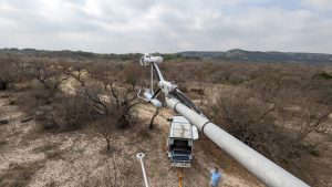
 IRGASON View Into Predominant Wind Direction
Looking generally into the predominant wind direction from the viewpoint of the IRGASON at US-EA5 showing general topography and vegetation (mostly mesquite) in the footprint of flux measurements at the site.
Keywords: —
Location: Texas, United States
View in Original Size
To download, right-click photo (Mac: control-click) and choose Save Image As
 US-EA5
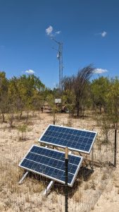
 Flux Tower at US-EA5 with Solar Panels
The flux tower located at the private ranch north of Uvalde (US-EA5) and the solar panels that powered the station.
Keywords: —
Location: Texas, United States
View in Original Size
To download, right-click photo (Mac: control-click) and choose Save Image As
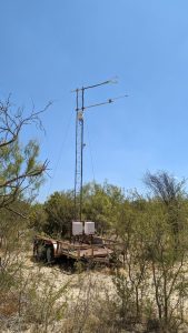
US-EA5 Flux Tower at US-EA5
The flux tower located at the private ranch north of Uvalde (US-EA5), surrounded by mesquite.
Keywords: —
Location: Texas, United States
View in Original Size
To download, right-click photo (Mac: control-click) and choose Save Image As
US-EA5: Uvalde Ranch Mesquite Woodland
- Overview
- Windroses
- Data Citation
- Data Use Log
- Image Gallery
- Remote Sensing Data
- MODIS
- PhenoCam
- GeoNEX
- Publications
- BADM
| AmeriFlux Publications | Add Publication |
| Year | Publication |
|---|---|
| 2024 | McKinney, S.T., Young, M.H. (2024) The Installation, Operation and Analysis of Eddy Covariance for Quantifying Evapotranspiration, Contract Report, 56. |
US-EA5: Uvalde Ranch Mesquite Woodland
- Overview
- Windroses
- Data Citation
- Data Use Log
- Image Gallery
- Remote Sensing Data
- MODIS
- PhenoCam
- GeoNEX
- Publications
- BADM
BADM for This Site
Access the Biological, Ancillary, Disturbance and Metadata (BADM) information and data for this site.
BADM contain information for many uses, such as characterizing a site’s vegetation and soil, describing disturbance history, and defining instrumentation for flux processing. They complement the flux/met data.
- Download BADM for this site*
- View Site General Info for this site (Overview tab)*
- Use Online Editor to update Site General Info or DOI Authorship
- Update information about submitted data (Variable Information tool)
- More BADM resources
* Online updates are shown on the Overview tab real time. However, downloaded BADM files will not reflect those updates until they have been reviewed for QA/QC.
US-EA5: Uvalde Ranch Mesquite Woodland
- Overview
- Windroses
- Data Citation
- Data Use Log
- Image Gallery
- Remote Sensing Data
- MODIS
- PhenoCam
- GeoNEX
- Publications
- BADM