
US-EA4: EAA Field Research Park Woodland
- Overview
- Windroses
- Data Citation
- Data Use Log
- Image Gallery
- Remote Sensing Data
- MODIS
- PhenoCam
- GeoNEX
- Publications
- BADM
| Tower_team: | |
| PI: | Marcus Gary marcus.gary@beg.utexas.edu - The University of Texas at Austin, Bureau of Economic Geology (UT-BEG) |
| PI: | Preston Fleck preston.fleck@beg.utexas.edu - The University of Texas at Austin, Bureau of Economic Geology (UT-BEG) |
| AncContact: | Michael Young michael.young@beg.utexas.edu - The University of Texas at Austin, Bureau of Economic Geology (UT-BEG) |
| Lat, Long: | 29.6633, -98.3816 |
| Elevation(m): | 297 |
| Network Affiliations: | AmeriFlux |
| Vegetation IGBP: | MF (Mixed Forests: Lands dominated by trees with a percent cover >60% and height exceeding 2 meters. Consists of tree communities with interspersed mixtures or mosaics of the other four forest types. None of the forest types exceeds 60% of landscape.) |
| Climate Koeppen: | Cfa (Humid Subtropical: mild with no dry season, hot summer) |
| Mean Annual Temp (°C): | 20.3 |
| Mean Annual Precip. (mm): | 836 |
| Flux Species Measured: | CO2, H2O |
| Years Data Collected: | 2021 - Present |
| Years Data Available: | AmeriFlux BASE 2021 - 2025 Data Citation AmeriFlux FLUXNET 2021 - 2025 Data Citation |
| Data Use Policy: | AmeriFlux CC-BY-4.0 Policy1 |
| Description: | |
| URL: | — |
| Research Topics: | Flux data processing |
| Acknowledgment: | Supported by the Edwards Aquifer Authority (EAA), under Contract No. 20-041-AMS to UT-BEG |
- This site’s data can also be used under the more restrictive AmeriFlux Legacy Policy.
The AmeriFlux Legacy Policy must be followed if this site’s data are combined with data from sites that require the AmeriFlux Legacy Policy.
Copyright preference: Request for permission
US-EA4: EAA Field Research Park Woodland
- Overview
- Windroses
- Data Citation
- Data Use Log
- Image Gallery
- Remote Sensing Data
- MODIS
- PhenoCam
- GeoNEX
- Publications
- BADM
Use the information below for citation of this site. See the Data Policy page for more details.
DOI(s) for citing US-EA4 data
Data Use Policy: AmeriFlux CC-BY-4.0 License
This site’s data can also be used under the more restrictive AmeriFlux Legacy Policy.
The AmeriFlux Legacy Policy must be followed if US-EA4 data are combined with data from sites that require the AmeriFlux Legacy Policy.
- AmeriFlux BASE: https://doi.org/10.17190/AMF/2315767
Citation: Tyson McKinney (2025), AmeriFlux BASE US-EA4 EAA Field Research Park Woodland, Ver. 2-5, AmeriFlux AMP, (Dataset). https://doi.org/10.17190/AMF/2315767 - AmeriFlux FLUXNET: https://doi.org/10.17190/AMF/3027353
Citation: Tyson McKinney (2026), AmeriFlux FLUXNET-1F US-EA4 EAA Field Research Park Woodland, Ver. v1.3_r1, AmeriFlux AMP, (Dataset). https://doi.org/10.17190/AMF/3027353
Find global FLUXNET datasets, like FLUXNET2015 and FLUXNET-CH4, and their citation information at fluxnet.org.
To cite BADM when downloaded on their own, use the publications below for citing site characterization. When using BADM that are downloaded with AmeriFlux BASE and AmeriFlux FLUXNET products, use the DOI citation for the associated data product.
Publication(s) for citing site characterization
- —
Acknowledgments
- —
Resources
- AmeriFlux Logos & Acknowledgments
US-EA4: EAA Field Research Park Woodland
- Overview
- Windroses
- Data Citation
- Data Use Log
- Image Gallery
- Remote Sensing Data
- MODIS
- PhenoCam
- GeoNEX
- Publications
- BADM

This page displays the list of downloads of data for the site {{siteId}}.
Note: Results are the number of downloads to distinct data users. The Download Count column indicates the number of times the data user downloaded the data. The Version column refers to the version of the data product for the site that was downloaded by the data user.
| Date | Name | Data Product | Vers. | Intended Use | Intended Use Description | Download Count |
|---|---|---|---|---|---|---|
| {{dlObject.timeStamp}} | {{dlObject.displayName}} | {{displayProduct(dlObject.dataProduct)}} | {{dlObject.version}} | {{dlObject.intendedUse}} | {{dlObject.comment}} | {{dlObject.downloadCounter}} |
Showing {{startItem + 1}} to {{(startItem + items) > filtered.length ? filtered.length : (startItem + items)}} of {{filtered.length}} results
Showing 0 to 0 of 0 results
Not Found
Uh Oh. Something is missing. Try double checking the URL and try again.
US-EA4: EAA Field Research Park Woodland
- Overview
- Windroses
- Data Citation
- Data Use Log
- Image Gallery
- Remote Sensing Data
- MODIS
- PhenoCam
- GeoNEX
- Publications
- BADM
| AmeriFlux Images | Add Image |
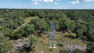
 US-EA4
 Drone photograph of flux tower (US-EA4) and surroundings.
Photograph of flux tower (US-EA4) taken with a drone looking into the predominant wind direction (SE) showing vegetation and topography representative of the region. Cibolo Creek is visible on the left side of the image.
Keywords: —
Location: Texas, United States
View in Original Size
To download, right-click photo (Mac: control-click) and choose Save Image As
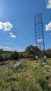
US-EA4 Drone photograph of flux tower.
Photograph of flux tower (US-EA4) taken with a drone looking into the predominant wind direction (SE).
Keywords: —
Location: Texas, United States
View in Original Size
To download, right-click photo (Mac: control-click) and choose Save Image As
 US-EA4
 Flux Tower
Photograph of flux tower (US-EA4).
Keywords: —
Location: Texas, United States
View in Original Size
To download, right-click photo (Mac: control-click) and choose Save Image As
US-EA4: EAA Field Research Park Woodland
- Overview
- Windroses
- Data Citation
- Data Use Log
- Image Gallery
- Remote Sensing Data
- MODIS
- PhenoCam
- GeoNEX
- Publications
- BADM
| AmeriFlux Publications | Add Publication |
| Year | Publication |
|---|---|
| 2024 | McKinney, S.T., Young, M.H. (2024) The Installation, Operation and Analysis of Eddy Covariance for Quantifying Evapotranspiration, Contract Report, 56. |
US-EA4: EAA Field Research Park Woodland
- Overview
- Windroses
- Data Citation
- Data Use Log
- Image Gallery
- Remote Sensing Data
- MODIS
- PhenoCam
- GeoNEX
- Publications
- BADM
BADM for This Site
Access the Biological, Ancillary, Disturbance and Metadata (BADM) information and data for this site.
BADM contain information for many uses, such as characterizing a site’s vegetation and soil, describing disturbance history, and defining instrumentation for flux processing. They complement the flux/met data.
- Download BADM for this site*
- View Site General Info for this site (Overview tab)*
- Use Online Editor to update Site General Info or DOI Authorship
- Update information about submitted data (Variable Information tool)
- More BADM resources
* Online updates are shown on the Overview tab real time. However, downloaded BADM files will not reflect those updates until they have been reviewed for QA/QC.
US-EA4: EAA Field Research Park Woodland
- Overview
- Windroses
- Data Citation
- Data Use Log
- Image Gallery
- Remote Sensing Data
- MODIS
- PhenoCam
- GeoNEX
- Publications
- BADM