
PE-TNR: Tambopata
- Overview
- Windroses
- Data Citation
- Data Use Log
- Image Gallery
- Remote Sensing Data
- MODIS
- PhenoCam
- GeoNEX
- Publications
- BADM
| Tower_team: | |
| PI: | Eric Cosio ecosio@pucp.pe - Sección Química, Pontificia Universidad Católica del Perú (PUCP) |
| PI: | Norma Salinas nsalinasr@pucp.pe - INTE-PUCP, Pontificia Universidad Católica del Perú (PUCP) |
| DataManager: | Robinson Negron-Juarez robinson.inj@lbl.gov - Lawrence Berkeley National Laboratory |
| Technician: | Rudi Cruz rcruzc@pucp.edu.pe - INTE-PUCP, Pontificia Universidad Católica del Perú (PUCP) |
| Lat, Long: | -12.8314, -69.2836 |
| Elevation(m): | 214 |
| Network Affiliations: | AmeriFlux |
| Vegetation IGBP: | MF (Mixed Forests: Lands dominated by trees with a percent cover >60% and height exceeding 2 meters. Consists of tree communities with interspersed mixtures or mosaics of the other four forest types. None of the forest types exceeds 60% of landscape.) |
| Climate Koeppen: | Af (Tropical rain forest) |
| Mean Annual Temp (°C): | 25.5 |
| Mean Annual Precip. (mm): | 2335 |
| Flux Species Measured: | CO2, H2O |
| Years Data Collected: | 2015 - Present |
| Years Data Available: | No data available |
| Data Use Policy: | AmeriFlux Legacy Policy |
| Description: | |
| URL: | — |
| Research Topics: | Carbon and water cycle dynamics through EC and biometric measurements in permanent forest plots. Calibrated CO2 air concentration (NOAA). |
| Acknowledgment: | Subcontract EU-Geocarbon 283080, grant 57-2018-FONDECYT-BM-IADT-MU, support from the Scottish Alliance for Geosciences and the Environment (SAGES), PUCP and AIDER (Peru). |
Copyright preference: Request for permission
PE-TNR: Tambopata
- Overview
- Windroses
- Data Citation
- Data Use Log
- Image Gallery
- Remote Sensing Data
- MODIS
- PhenoCam
- GeoNEX
- Publications
- BADM
Use the information below for citation of this site. See the Data Policy page for more details.
DOI(s) for citing PE-TNR data
Data Use Policy: AmeriFlux Legacy Policy
- No DOIs available for PE-TNR
To cite BADM downloaded as a BIF file, use the publications listed below.
Publication(s) for citing site characterization
- —
Acknowledgments
- —
Resources
- AmeriFlux Logos & Acknowledgments
PE-TNR: Tambopata
- Overview
- Windroses
- Data Citation
- Data Use Log
- Image Gallery
- Remote Sensing Data
- MODIS
- PhenoCam
- GeoNEX
- Publications
- BADM

This page displays the list of downloads of data for the site {{siteId}}.
Note: Results are the number of downloads to distinct data users. The Download Count column indicates the number of times the data user downloaded the data. The Version column refers to the version of the data product for the site that was downloaded by the data user.
| Date | Name | Data Product | Vers. | Intended Use | Intended Use Description | Download Count |
|---|---|---|---|---|---|---|
| {{dlObject.timeStamp}} | {{dlObject.displayName}} | {{displayProduct(dlObject.dataProduct)}} | {{dlObject.version}} | {{dlObject.intendedUse}} | {{dlObject.comment}} | {{dlObject.downloadCounter}} |
Showing {{startItem + 1}} to {{(startItem + items) > filtered.length ? filtered.length : (startItem + items)}} of {{filtered.length}} results
Showing 0 to 0 of 0 results
Not Found
Uh Oh. Something is missing. Try double checking the URL and try again.
PE-TNR: Tambopata
- Overview
- Windroses
- Data Citation
- Data Use Log
- Image Gallery
- Remote Sensing Data
- MODIS
- PhenoCam
- GeoNEX
- Publications
- BADM
| AmeriFlux Images | Add Image |
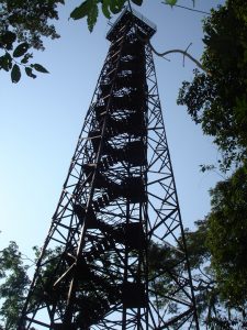
PE-TNR Tower structure
45m self-sustaining tower with staircase inner structure.
Keywords: tower
Location: Peru
View in Original Size
To download, right-click photo (Mac: control-click) and choose Save Image As
 PE-TNR
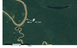
 Tower location
Map showing the distance from the tower to the Tambopata River (800m).
Keywords: location,distance
Location: Peru
View in Original Size
To download, right-click photo (Mac: control-click) and choose Save Image As
 PE-TNR
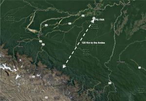
 Tower location to the Andres
Map showing the distance from the tower to the Andes foothills (120 Km).
Keywords: location,distance
Location: Peru
View in Original Size
To download, right-click photo (Mac: control-click) and choose Save Image As
 PE-TNR
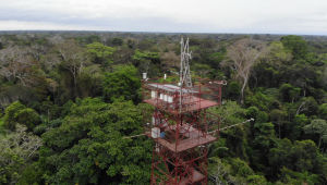
 Aerial view
View of the top platform. Most of the equipment is visible. Equipment includes Li7200RS IRGA,CSAT3 sonic anemometer,Li840 gas analyzer,Li820 gas analyzer,NR01 net radiometer,Li190R quantum PAR sensor,HMP155 humidity and temperature probe,photovoltaic system.
Keywords: IRGA,net radiometer,PAR
Location: Peru
View in Original Size
To download, right-click photo (Mac: control-click) and choose Save Image As
PE-TNR: Tambopata
- Overview
- Windroses
- Data Citation
- Data Use Log
- Image Gallery
- Remote Sensing Data
- MODIS
- PhenoCam
- GeoNEX
- Publications
- BADM
| AmeriFlux Publications | Add Publication |
| Year | Publication |
|---|---|
| 2016 | Vihermaa, L. E., Waldron, S., Domingues, T., Grace, J., Cosio, E. G., Limonchi, F., Hopkinson, C., da Rocha, H. R., Gloor, E. (2016) Fluvial Carbon Export From A Lowland Amazonian Rainforest In Relation To Atmospheric Fluxes, Journal Of Geophysical Research: Biogeosciences, 121(12), 3001-3018. https://doi.org/10.1002/2016JG003464 |
PE-TNR: Tambopata
- Overview
- Windroses
- Data Citation
- Data Use Log
- Image Gallery
- Remote Sensing Data
- MODIS
- PhenoCam
- GeoNEX
- Publications
- BADM
BADM for This Site
Access the Biological, Ancillary, Disturbance and Metadata (BADM) information and data for this site.
BADM contain information for many uses, such as characterizing a site’s vegetation and soil, describing disturbance history, and defining instrumentation for flux processing. They complement the flux/met data.
- Download BADM for this site*
- View Site General Info for this site (Overview tab)*
- Use Online Editor to update Site General Info or DOI Authorship
- Update information about submitted data (Variable Information tool)
- More BADM resources
* Online updates are shown on the Overview tab real time. However, downloaded BADM files will not reflect those updates until they have been reviewed for QA/QC.
PE-TNR: Tambopata
- Overview
- Windroses
- Data Citation
- Data Use Log
- Image Gallery
- Remote Sensing Data
- MODIS
- PhenoCam
- GeoNEX
- Publications
- BADM