
PE-QFR: Quistococha Forest Reserve
- Overview
- Windroses
- Data Citation
- Data Use Log
- Image Gallery
- Remote Sensing Data
- MODIS
- PhenoCam
- GeoNEX
- Publications
- BADM
| Tower_team: | |
| PI: | Timothy Griffis tgriffis@umn.edu - University of Minnesota |
| FluxContact: | Tyler Roman tyler.roman@fs-ip.us - USDA- Forest Service |
| Technician: | Jhon Rengifo jrengifo@iiap.gob.pe - Peruvian Amazon Research Institute |
| Technician: | Lizardo Fachin Malaverri lfachin@iiap.gob.pe - Peruvian Amazon Research Institute |
| Lat, Long: | -3.8344, -73.3190 |
| Elevation(m): | 104 |
| Network Affiliations: | AmeriFlux |
| Vegetation IGBP: | WET (Permanent Wetlands: Lands with a permanent mixture of water and herbaceous or woody vegetation that cover extensive areas. The vegetation can be present in either salt, brackish, or fresh water) |
| Climate Koeppen: | Af (Tropical rain forest) |
| Mean Annual Temp (°C): | — |
| Mean Annual Precip. (mm): | — |
| Flux Species Measured: | CO2, H2O, CH4 |
| Years Data Collected: | 2018 - Present |
| Years Data Available: | AmeriFlux BASE 2018 - 2022 Data Citation AmeriFlux FLUXNET 2018 - 2022 Data Citation |
| Data Use Policy: | AmeriFlux CC-BY-4.0 Policy1 |
| Description: | |
| URL: | https://biometeorology.umn.edu/research/quistococha-forest-reserve-qfr-amazonian-ameriflux-site-iquitos-peru |
| Research Topics: | — |
| Acknowledgment: | — |
- This site’s data can also be used under the more restrictive AmeriFlux Legacy Policy.
The AmeriFlux Legacy Policy must be followed if this site’s data are combined with data from sites that require the AmeriFlux Legacy Policy.
Copyright preference: As long as credit is given
PE-QFR: Quistococha Forest Reserve
- Overview
- Windroses
- Data Citation
- Data Use Log
- Image Gallery
- Remote Sensing Data
- MODIS
- PhenoCam
- GeoNEX
- Publications
- BADM
Use the information below for citation of this site. See the Data Policy page for more details.
DOI(s) for citing PE-QFR data
Data Use Policy: AmeriFlux CC-BY-4.0 License
This site’s data can also be used under the more restrictive AmeriFlux Legacy Policy.
The AmeriFlux Legacy Policy must be followed if PE-QFR data are combined with data from sites that require the AmeriFlux Legacy Policy.
- AmeriFlux BASE: https://doi.org/10.17190/AMF/1671889
Citation: Tyler Roman, Timothy Griffis, Randy Kolka, Craig Wayson, Erik Lilleskov, Dennis del Castillo, Lizardo Fachín, Jhon Rengifo (2025), AmeriFlux BASE PE-QFR Quistococha Forest Reserve, Ver. 3-5, AmeriFlux AMP, (Dataset). https://doi.org/10.17190/AMF/1671889 - AmeriFlux FLUXNET: https://doi.org/10.17190/AMF/1832157
Citation: Tyler Roman, Timothy Griffis, Randy Kolka, Craig Wayson, Erik Lilleskov, Dennis del Castillo, Lizardo Fachín, Jhon Rengifo (2026), AmeriFlux FLUXNET-1F PE-QFR Quistococha Forest Reserve, Ver. v1.3_r1, AmeriFlux AMP, (Dataset). https://doi.org/10.17190/AMF/1832157
Find global FLUXNET datasets, like FLUXNET2015 and FLUXNET-CH4, and their citation information at fluxnet.org.
To cite BADM when downloaded on their own, use the publications below for citing site characterization. When using BADM that are downloaded with AmeriFlux BASE and AmeriFlux FLUXNET products, use the DOI citation for the associated data product.
Publication(s) for citing site characterization
- —
Acknowledgments
- —
Resources
- AmeriFlux Logos & Acknowledgments
PE-QFR: Quistococha Forest Reserve
- Overview
- Windroses
- Data Citation
- Data Use Log
- Image Gallery
- Remote Sensing Data
- MODIS
- PhenoCam
- GeoNEX
- Publications
- BADM

This page displays the list of downloads of data for the site {{siteId}}.
Note: Results are the number of downloads to distinct data users. The Download Count column indicates the number of times the data user downloaded the data. The Version column refers to the version of the data product for the site that was downloaded by the data user.
| Date | Name | Data Product | Vers. | Intended Use | Intended Use Description | Download Count |
|---|---|---|---|---|---|---|
| {{dlObject.timeStamp}} | {{dlObject.displayName}} | {{displayProduct(dlObject.dataProduct)}} | {{dlObject.version}} | {{dlObject.intendedUse}} | {{dlObject.comment}} | {{dlObject.downloadCounter}} |
Showing {{startItem + 1}} to {{(startItem + items) > filtered.length ? filtered.length : (startItem + items)}} of {{filtered.length}} results
Showing 0 to 0 of 0 results
Not Found
Uh Oh. Something is missing. Try double checking the URL and try again.
PE-QFR: Quistococha Forest Reserve
- Overview
- Windroses
- Data Citation
- Data Use Log
- Image Gallery
- Remote Sensing Data
- MODIS
- PhenoCam
- GeoNEX
- Publications
- BADM
| AmeriFlux Images | Add Image |
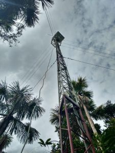
PE-QFR Tower_from_ground
Pictures of the tower from the ground level
Keywords: —
Location: Peru
View in Original Size
To download, right-click photo (Mac: control-click) and choose Save Image As
PE-QFR: Quistococha Forest Reserve
- Overview
- Windroses
- Data Citation
- Data Use Log
- Image Gallery
- Remote Sensing Data
- MODIS
- PhenoCam
- GeoNEX
- Publications
- BADM
| AmeriFlux Publications | Add Publication |
| Year | Publication |
|---|---|
| 2020 | Griffis, T., Roman, D., Wood, J., Deventer, J., Fachin, L., Rengifo, J., Del Castillo, D., Lilleskov, E., Kolka, R., Chimner, R., del Aguila-Pasquel, J., Wayson, C., Hergoualc'h, K., Baker, J., Cadillo-Quiroz, H., Ricciuto, D. (2020) Hydrometeorological Sensitivities Of Net Ecosystem Carbon Dioxide And Methane Exchange Of An Amazonian Palm Swamp Peatland, Agricultural And Forest Meteorology, 295, 108167. https://doi.org/10.1016/j.agrformet.2020.108167 |
PE-QFR: Quistococha Forest Reserve
- Overview
- Windroses
- Data Citation
- Data Use Log
- Image Gallery
- Remote Sensing Data
- MODIS
- PhenoCam
- GeoNEX
- Publications
- BADM
BADM for This Site
Access the Biological, Ancillary, Disturbance and Metadata (BADM) information and data for this site.
BADM contain information for many uses, such as characterizing a site’s vegetation and soil, describing disturbance history, and defining instrumentation for flux processing. They complement the flux/met data.
- Download BADM for this site*
- View Site General Info for this site (Overview tab)*
- Use Online Editor to update Site General Info or DOI Authorship
- Update information about submitted data (Variable Information tool)
- More BADM resources
* Online updates are shown on the Overview tab real time. However, downloaded BADM files will not reflect those updates until they have been reviewed for QA/QC.
PE-QFR: Quistococha Forest Reserve
- Overview
- Windroses
- Data Citation
- Data Use Log
- Image Gallery
- Remote Sensing Data
- MODIS
- PhenoCam
- GeoNEX
- Publications
- BADM
Wind Roses
Wind Speed (m/s)
- Wind Speed Scale: Per Site
- Wind Direction Scale (%): Per Site
- Wind Speed Scale: Non-Linear
- Wind Direction Scale (%): AmeriFlux