
CA-Mer: Ontario - Eastern Peatland, Mer Bleue
- Overview
- Windroses
- Data Citation
- Data Use Log
- Image Gallery
- Remote Sensing Data
- MODIS
- PhenoCam
- GeoNEX
- Publications
- BADM
| Tower_team: | |
| PI: | Elyn Humphreys elyn.humphreys@carleton.ca - Carleton University |
| DataManager: | Phaedra Cowden phaedracowden@cunet.carleton.ca - Carleton University |
| Lat, Long: | 45.4094, -75.5186 |
| Elevation(m): | 70 |
| Network Affiliations: | AmeriFlux, Fluxnet-Canada, Phenocam |
| Vegetation IGBP: | WET (Permanent Wetlands: Lands with a permanent mixture of water and herbaceous or woody vegetation that cover extensive areas. The vegetation can be present in either salt, brackish, or fresh water) |
| Climate Koeppen: | Dfb (Warm Summer Continental: significant precipitation in all seasons ) |
| Mean Annual Temp (°C): | 6 |
| Mean Annual Precip. (mm): | 943 |
| Flux Species Measured: | CO2 |
| Years Data Collected: | 1998 - Present |
| Years Data Available: | AmeriFlux BASE 1998 - 2020 Data Citation AmeriFlux FLUXNET 1998 - 2020 Data Citation |
| Data Use Policy: | AmeriFlux CC-BY-4.0 Policy1 |
| Description: | |
| URL: | https://carleton.ca/cubiomet/research/mer-bleue/ |
| Research Topics: | — |
| Acknowledgment: | — |
- This site’s data can also be used under the more restrictive AmeriFlux Legacy Policy.
The AmeriFlux Legacy Policy must be followed if this site’s data are combined with data from sites that require the AmeriFlux Legacy Policy.
Copyright preference: As long as credit is given
CA-Mer: Ontario - Eastern Peatland, Mer Bleue
- Overview
- Windroses
- Data Citation
- Data Use Log
- Image Gallery
- Remote Sensing Data
- MODIS
- PhenoCam
- GeoNEX
- Publications
- BADM
Use the information below for citation of this site. See the Data Policy page for more details.
DOI(s) for citing CA-Mer data
Data Use Policy: AmeriFlux CC-BY-4.0 License
This site’s data can also be used under the more restrictive AmeriFlux Legacy Policy.
The AmeriFlux Legacy Policy must be followed if CA-Mer data are combined with data from sites that require the AmeriFlux Legacy Policy.
- AmeriFlux BASE: https://doi.org/10.17190/AMF/2448423
Citation: Elyn Humphreys, Peter Lafleur (2024), AmeriFlux BASE CA-Mer Ontario - Eastern Peatland, Mer Bleue, Ver. 2-5, AmeriFlux AMP, (Dataset). https://doi.org/10.17190/AMF/2448423 - AmeriFlux FLUXNET: https://doi.org/10.17190/AMF/2571102
Citation: Elyn Humphreys, Peter Lafleur (2025), AmeriFlux FLUXNET-1F CA-Mer Ontario - Eastern Peatland, Mer Bleue, Ver. v1.3_r1, AmeriFlux AMP, (Dataset). https://doi.org/10.17190/AMF/2571102
Find global FLUXNET datasets, like FLUXNET2015 and FLUXNET-CH4, and their citation information at fluxnet.org.
To cite BADM when downloaded on their own, use the publications below for citing site characterization. When using BADM that are downloaded with AmeriFlux BASE and AmeriFlux FLUXNET products, use the DOI citation for the associated data product.
Publication(s) for citing site characterization
- —
Acknowledgments
- —
Resources
- AmeriFlux Logos & Acknowledgments
CA-Mer: Ontario - Eastern Peatland, Mer Bleue
- Overview
- Windroses
- Data Citation
- Data Use Log
- Image Gallery
- Remote Sensing Data
- MODIS
- PhenoCam
- GeoNEX
- Publications
- BADM

This page displays the list of downloads of data for the site {{siteId}}.
Note: Results are the number of downloads to distinct data users. The Download Count column indicates the number of times the data user downloaded the data. The Version column refers to the version of the data product for the site that was downloaded by the data user.
| Date | Name | Data Product | Vers. | Intended Use | Intended Use Description | Download Count |
|---|---|---|---|---|---|---|
| {{dlObject.timeStamp}} | {{dlObject.displayName}} | {{displayProduct(dlObject.dataProduct)}} | {{dlObject.version}} | {{dlObject.intendedUse}} | {{dlObject.comment}} | {{dlObject.downloadCounter}} |
Showing {{startItem + 1}} to {{(startItem + items) > filtered.length ? filtered.length : (startItem + items)}} of {{filtered.length}} results
Showing 0 to 0 of 0 results
Not Found
Uh Oh. Something is missing. Try double checking the URL and try again.
CA-Mer: Ontario - Eastern Peatland, Mer Bleue
- Overview
- Windroses
- Data Citation
- Data Use Log
- Image Gallery
- Remote Sensing Data
- MODIS
- PhenoCam
- GeoNEX
- Publications
- BADM
| AmeriFlux Images | Add Image |
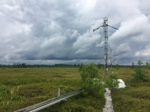
CA-Mer Mer Bleue flux tower
Mer Bleue bog flux tower, Ontario Canada
Keywords: peatland, bog, eddy covariance, Mer Bleue, Ontario
Location: Ontario, Canada
View in Original Size
To download, right-click photo (Mac: control-click) and choose Save Image As
CA-Mer: Ontario - Eastern Peatland, Mer Bleue
- Overview
- Windroses
- Data Citation
- Data Use Log
- Image Gallery
- Remote Sensing Data
- MODIS
- PhenoCam
- GeoNEX
- Publications
- BADM
MODIS NDVI
The time series shows the 16-day Normalized Difference Vegetation Index (NDVI) average from the MOD13Q1 data product.
Use the slider below the time series to zoom in and out.
To view / download these data and other MOD13Q1 products for this site, visit MODIS/Terra Vegetation Indices.
For other related products, visit MODIS/VIIRS Fixed Sites Subsets Tool.
Citation:
ORNL DAAC. 2018. Terrestrial Ecology Subsetting & Visualization Services (TESViS) Fixed Sites Subsets. ORNL DAAC, Oak Ridge, Tennessee, USA. https://doi.org/10.3334/ORNLDAAC/1567
MODIS NDVI subsetted data is not yet available for this site.
For a complete list of AmeriFlux sites, visit ORNL DAAC's MODIS/VIIRS Fixed Sites Subsets Tool.


CA-Mer: Ontario - Eastern Peatland, Mer Bleue
- Overview
- Windroses
- Data Citation
- Data Use Log
- Image Gallery
- Remote Sensing Data
- MODIS
- PhenoCam
- GeoNEX
- Publications
- BADM
| AmeriFlux Publications | Add Publication |
| Year | Publication |
|---|---|
| 2014 | Humphreys, E. R., Charron, C., Brown, M., Jones, R. (2014) Two Bogs In The Canadian Hudson Bay Lowlands And A Temperate Bog Reveal Similar Annual Net Ecosystem Exchange Of Co2, Arctic, Antarctic, And Alpine Research, 46(1), 103-113. https://doi.org/10.1657/1938-4246.46.1.103 |
| 2013 | Barr, A., Richardson, A., Hollinger, D., Papale, D., Arain, M., Black, T., Bohrer, G., Dragoni, D., Fischer, M., Gu, L., Law, B., Margolis, H., McCaughey, J., Munger, J., Oechel, W., Schaeffer, K. (2013) Use Of Change-Point Detection For Friction–Velocity Threshold Evaluation In Eddy-Covariance Studies, Agricultural And Forest Meteorology, 171-172, 31-45. https://doi.org/10.1016/j.agrformet.2012.11.023 |
| 2018 | Qiu, C., Zhu, D., Ciais, P., Guenet, B., Krinner, G., Peng, S., Aurela, M., Bernhofer, C., Brümmer, C., Bret-Harte, S., Chu, H., Chen, J., Desai, A. R., Dušek, J., Euskirchen, E. S., Fortuniak, K., Flanagan, L. B., Friborg, T., Grygoruk, M., Gogo, S., Grünwald, T., Hansen, B. U., Holl, D., Humphreys, E., Hurkuck, M., Kiely, G., Klatt, J., Kutzbach, L., Largeron, C., Laggoun-Défarge, F., Lund, M., Lafleur, P. M., Li, X., Mammarella, I., Merbold, L., Nilsson, M. B., Olejnik, J., Ottosson-Löfvenius, M., Oechel, W., Parmentier, F. W., Peichl, M., Pirk, N., Peltola, O., Pawlak, W., Rasse, D., Rinne, J., Shaver, G., Schmid, H. P., Sottocornola, M., Steinbrecher, R., Sachs, T., Urbaniak, M., Zona, D., Ziemblinska, K. (2018) Orchidee-Peat (Revision 4596), A Model For Northern Peatland Co≪Sub≫2≪/Sub≫, Water, And Energy Fluxes On Daily To Annual Scales, Geoscientific Model Development, 11(2), 497-519. https://doi.org/10.5194/gmd-11-497-2018 |
| 2015 | Dennis Baldocchi, Cove Sturtevant (2015) Does day and night sampling reduce spurious correlation between canopy photosynthesis and ecosystem respiration?, Agricultural and Forest Meteorology, 207, 117-126. https://doi.org/10.1016/j.agrformet.2015.03.010 |
| 2001 | Lafleur, P. M., Roulet, N. T., Admiral, S. W. (2001) Annual Cycle Of CO2 Exchange At A Bog Peatland, Journal Of Geophysical Research: Atmospheres, 106(D3), 3071-3081. https://doi.org/10.1029/2000jd900588 |
| 2004 | Ham, J. M., Benson, E. J. (2004) On The Construction And Calibration Of Dual-Probe Heat Capacity Sensors, Soil Science Society Of America Journal, 68(4), 1185-1190. https://doi.org/10.2136/sssaj2004.1185 |
| 2003 | Lafleur, P. M., Roulet, N. T., Bubier, J. L., Frolking, S., Moore, T. R. (2003) Interannual Variability In The Peatland-Atmosphere Carbon Dioxide Exchange At An Ombrotrophic Bog, Global Biogeochemical Cycles, 17(2), n/a-n/a. https://doi.org/10.1029/2002gb001983 |
| 2002 | Moore, T. R., Bubier, J. L., Frolking, S. E., Lafleur, P. M., Roulet, N. T. (2002) Plant Biomass And Production And CO2 Exchange In An Ombrotrophic Bog, Journal Of Ecology, 90(1), 25-36. https://doi.org/10.1046/j.0022-0477.2001.00633.x |
| 2001 | Fraser, C., Roulet, N., Lafleur, M. (2001) Groundwater Flow Patterns In A Large Peatland, Journal Of Hydrology, 246(1-4), 142-154. https://doi.org/10.1016/s0022-1694(01)00362-6 |
| 1997 | Berry, S. C., Varney, G. T., Flanagan, L. B. (1997) Leaf δ13C In Pinus Resinosa Trees And Understory Plants: Variation Associated With Light And CO2 Gradients, Oecologia, 109(4), 499-506. https://doi.org/10.1007/s004420050110 |
| 1998 | Frolking, S. E., Bubier, J. L., Moore, T. R., Ball, T., Bellisario, L. M., Bhardwaj, A., Carroll, P., Crill, P. M., Lafleur, P. M., McCaughey, J. H., Roulet, N. T., Suyker, A. E., Verma, S. B., Waddington, J. M., Whiting, G. J. (1998) Relationship Between Ecosystem Productivity And Photosynthetically Active Radiation For Northern Peatlands, Global Biogeochemical Cycles, 12(1), 115-126. https://doi.org/10.1029/97gb03367 |
| 2002 | Frolking, S., Roulet, N. T., Moore, T. R., Lafleur, P. M., Bubier, J. L., Crill, P. M. (2002) Modeling Seasonal To Annual Carbon Balance Of Mer Bleue Bog, Ontario, Canada, Global Biogeochemical Cycles, 16(3), 1-21. https://doi.org/10.1029/2001gb001457 |
| 2004 | Turunen, J., Roulet, N. T., Moore, T. R., Richard, P. J. (2004) Nitrogen Deposition And Increased Carbon Accumulation In Ombrotrophic Peatlands In Eastern Canada, Global Biogeochemical Cycles, 18(3), n/a-n/a. https://doi.org/10.1029/2003gb002154 |
CA-Mer: Ontario - Eastern Peatland, Mer Bleue
- Overview
- Windroses
- Data Citation
- Data Use Log
- Image Gallery
- Remote Sensing Data
- MODIS
- PhenoCam
- GeoNEX
- Publications
- BADM
BADM for This Site
Access the Biological, Ancillary, Disturbance and Metadata (BADM) information and data for this site.
BADM contain information for many uses, such as characterizing a site’s vegetation and soil, describing disturbance history, and defining instrumentation for flux processing. They complement the flux/met data.
- Download BADM for this site*
- View Site General Info for this site (Overview tab)*
- Use Online Editor to update Site General Info or DOI Authorship
- Update information about submitted data (Variable Information tool)
- More BADM resources
* Online updates are shown on the Overview tab real time. However, downloaded BADM files will not reflect those updates until they have been reviewed for QA/QC.
CA-Mer: Ontario - Eastern Peatland, Mer Bleue
- Overview
- Windroses
- Data Citation
- Data Use Log
- Image Gallery
- Remote Sensing Data
- MODIS
- PhenoCam
- GeoNEX
- Publications
- BADM