
CA-Ca3: British Columbia - Pole sapling Douglas-fir stand
- Overview
- Windroses
- Data Citation
- Data Use Log
- Image Gallery
- Remote Sensing Data
- MODIS
- PhenoCam
- GeoNEX
- Publications
- BADM
| Tower_team: | |
| PI: | T. Andrew Black andrew.black@ubc.ca - University of British Columbia, Vancouver |
| FluxContact: | Zoran Nesic zoran.nesic@ubc.ca - UBC Vancouver |
| BADMContact: | Paul Jassal rachhpal.jassal@ubc.ca - UBC Vancouver |
| Lat, Long: | 49.5346, -124.9004 |
| Elevation(m): | — |
| Network Affiliations: | AmeriFlux, Fluxnet-Canada, Phenocam |
| Vegetation IGBP: | ENF (Evergreen Needleleaf Forests: Lands dominated by woody vegetation with a percent cover >60% and height exceeding 2 meters. Almost all trees remain green all year. Canopy is never without green foliage.) |
| Climate Koeppen: | Cfb (Marine West Coast: mild with no dry season, warm summer) |
| Mean Annual Temp (°C): | 9.94 |
| Mean Annual Precip. (mm): | 1676 |
| Flux Species Measured: | CO2 |
| Years Data Collected: | 2001 - Present |
| Years Data Available: | AmeriFlux BASE 2001 - 2024 Data Citation AmeriFlux FLUXNET 2001 - 2024 Data Citation |
| Data Use Policy: | AmeriFlux CC-BY-4.0 Policy1 |
| Description: | |
| URL: | http://www.fluxnet-canada.ca/ |
| Research Topics: | — |
| Acknowledgment: | — |
- This site’s data can also be used under the more restrictive AmeriFlux Legacy Policy.
The AmeriFlux Legacy Policy must be followed if this site’s data are combined with data from sites that require the AmeriFlux Legacy Policy.
Copyright preference: Open use
CA-Ca3: British Columbia - Pole sapling Douglas-fir stand
- Overview
- Windroses
- Data Citation
- Data Use Log
- Image Gallery
- Remote Sensing Data
- MODIS
- PhenoCam
- GeoNEX
- Publications
- BADM
Use the information below for citation of this site. See the Data Policy page for more details.
DOI(s) for citing CA-Ca3 data
Data Use Policy: AmeriFlux CC-BY-4.0 License
This site’s data can also be used under the more restrictive AmeriFlux Legacy Policy.
The AmeriFlux Legacy Policy must be followed if CA-Ca3 data are combined with data from sites that require the AmeriFlux Legacy Policy.
- AmeriFlux BASE: https://doi.org/10.17190/AMF/1480302
Citation: T. Andrew Black (2025), AmeriFlux BASE CA-Ca3 British Columbia - Pole sapling Douglas-fir stand, Ver. 7-5, AmeriFlux AMP, (Dataset). https://doi.org/10.17190/AMF/1480302 - AmeriFlux FLUXNET: https://doi.org/10.17190/AMF/3027312
Citation: T. Andrew Black (2026), AmeriFlux FLUXNET-1F CA-Ca3 British Columbia - Pole sapling Douglas-fir stand, Ver. v1.3_r1, AmeriFlux AMP, (Dataset). https://doi.org/10.17190/AMF/3027312
Find global FLUXNET datasets, like FLUXNET2015 and FLUXNET-CH4, and their citation information at fluxnet.org.
To cite BADM when downloaded on their own, use the publications below for citing site characterization. When using BADM that are downloaded with AmeriFlux BASE and AmeriFlux FLUXNET products, use the DOI citation for the associated data product.
Publication(s) for citing site characterization
- —
Acknowledgments
- —
Resources
- AmeriFlux Logos & Acknowledgments
CA-Ca3: British Columbia - Pole sapling Douglas-fir stand
- Overview
- Windroses
- Data Citation
- Data Use Log
- Image Gallery
- Remote Sensing Data
- MODIS
- PhenoCam
- GeoNEX
- Publications
- BADM

This page displays the list of downloads of data for the site {{siteId}}.
Note: Results are the number of downloads to distinct data users. The Download Count column indicates the number of times the data user downloaded the data. The Version column refers to the version of the data product for the site that was downloaded by the data user.
| Date | Name | Data Product | Vers. | Intended Use | Intended Use Description | Download Count |
|---|---|---|---|---|---|---|
| {{dlObject.timeStamp}} | {{dlObject.displayName}} | {{displayProduct(dlObject.dataProduct)}} | {{dlObject.version}} | {{dlObject.intendedUse}} | {{dlObject.comment}} | {{dlObject.downloadCounter}} |
Showing {{startItem + 1}} to {{(startItem + items) > filtered.length ? filtered.length : (startItem + items)}} of {{filtered.length}} results
Showing 0 to 0 of 0 results
Not Found
Uh Oh. Something is missing. Try double checking the URL and try again.
CA-Ca3: British Columbia - Pole sapling Douglas-fir stand
- Overview
- Windroses
- Data Citation
- Data Use Log
- Image Gallery
- Remote Sensing Data
- MODIS
- PhenoCam
- GeoNEX
- Publications
- BADM
| AmeriFlux Images | Add Image |
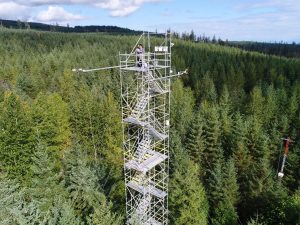
CA-Ca3 Ca-Ca3 Tower 2018
The new scaffold Ca-Ca3 Tower built in 2017 with the old tower that was operated until 2017 in the right (red / white). View towards NW
Keywords: Tower,Eddy Covariance,Forest
Location: British Columbia, Canada
View in Original Size
To download, right-click photo (Mac: control-click) and choose Save Image As
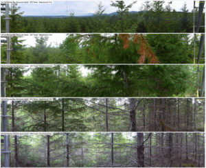 CA-Ca3
 Panoramas at 3, 7, 11, 15 and 19 m from new Ca-Ca3 tower.
270º Panoramas in trunk and crown space (3, 7, 11, 15 and 19 m above ground level) from N (left) to W (right) from SE-corner of new 32m tall 2017 Fluxnet Tower "CA-Ca3" near Buckley Bay, BC, Canada. All photos taken on July 19, 2017. individual panoramas are available under https://flic.kr/s/aHskScKAYJ
Keywords: Panorama, Buckley Bay, Trunk space, Crown Space, Canopy structure, CA-Ca3
Location: British Columbia, Canada
View in Original Size
To download, right-click photo (Mac: control-click) and choose Save Image As
CA-Ca3: British Columbia - Pole sapling Douglas-fir stand
- Overview
- Windroses
- Data Citation
- Data Use Log
- Image Gallery
- Remote Sensing Data
- MODIS
- PhenoCam
- GeoNEX
- Publications
- BADM
MODIS NDVI
The time series shows the 16-day Normalized Difference Vegetation Index (NDVI) average from the MOD13Q1 data product.
Use the slider below the time series to zoom in and out.
To view / download these data and other MOD13Q1 products for this site, visit MODIS/Terra Vegetation Indices.
For other related products, visit MODIS/VIIRS Fixed Sites Subsets Tool.
Citation:
ORNL DAAC. 2018. Terrestrial Ecology Subsetting & Visualization Services (TESViS) Fixed Sites Subsets. ORNL DAAC, Oak Ridge, Tennessee, USA. https://doi.org/10.3334/ORNLDAAC/1567
MODIS NDVI subsetted data is not yet available for this site.
For a complete list of AmeriFlux sites, visit ORNL DAAC's MODIS/VIIRS Fixed Sites Subsets Tool.


CA-Ca3: British Columbia - Pole sapling Douglas-fir stand
- Overview
- Windroses
- Data Citation
- Data Use Log
- Image Gallery
- Remote Sensing Data
- MODIS
- PhenoCam
- GeoNEX
- Publications
- BADM
| AmeriFlux Publications | Add Publication |
| Year | Publication |
|---|---|
| 2020 | Xu, B., Arain, M. A., Black, T. A., Law, B. E., Pastorello, G. Z., Chu, H. (2020) Seasonal Variability Of Forest Sensitivity To Heat And Drought Stresses: A Synthesis Based On Carbon Fluxes From North American Forest Ecosystems, Global Change Biology, 26(2), 901-918. https://doi.org/10.1111/gcb.14843 |
| 2021 | Chu, H., Luo, X., Ouyang, Z., Chan, W. S., Dengel, S., Biraud, S. C., Torn, M. S., Metzger, S., Kumar, J., Arain, M. A., Arkebauer, T. J., Baldocchi, D., Bernacchi, C., Billesbach, D., Black, T. A., Blanken, P. D., Bohrer, G., Bracho, R., Brown, S., Brunsell, N. A., Chen, J., Chen, X., Clark, K., Desai, A. R., Duman, T., Durden, D., Fares, S., Forbrich, I., Gamon, J. A., Gough, C. M., Griffis, T., Helbig, M., Hollinger, D., Humphreys, E., Ikawa, H., Iwata, H., Ju, Y., Knowles, J. F., Knox, S. H., Kobayashi, H., Kolb, T., Law, B., Lee, X., Litvak, M., Liu, H., Munger, J. W., Noormets, A., Novick, K., Oberbauer, S. F., Oechel, W., Oikawa, P., Papuga, S. A., Pendall, E., Prajapati, P., Prueger, J., Quinton, W. L., Richardson, A. D., Russell, E. S., Scott, R. L., Starr, G., Staebler, R., Stoy, P. C., Stuart-Haëntjens, E., Sonnentag, O., Sullivan, R. C., Suyker, A., Ueyama, M., Vargas, R., Wood, J. D., Zona, D. (2021) Representativeness Of Eddy-Covariance Flux Footprints For Areas Surrounding Ameriflux Sites, Agricultural And Forest Meteorology, 301-302, 108350. https://doi.org/10.1016/j.agrformet.2021.108350 |
| 2019 | McKendry, I. G., Christen, A., Lee, S., Ferrara, M., Strawbridge, K. B., O'Neill, N., Black, A. (2019) Impacts Of An Intense Wildfire Smoke Episode On Surface Radiation, Energy And Carbon Fluxes In Southwestern British Columbia, Canada, Atmospheric Chemistry And Physics, 19(2), 835-846. https://doi.org/https://doi.org/10.5194/acp-19-835-2019 |
| 2020 | Lee, S., Christen, A., Black, T. A., Jassal, R. S., Ketler, R., Nesic, Z. (2020) Partitioning Of Net Ecosystem Exchange Into Photosynthesis And Respiration Using Continuous Stable Isotope Measurements In A Pacific Northwest Douglas-Fir Forest Ecosystem, Agricultural And Forest Meteorology, 292-293, 108109. https://doi.org/https://doi.org/10.1016/j.agrformet.2020.108109 |
| 2020 | Lee, S., Black, T. A., Jassal, R. S., Christen, A., Meyer, G., Nesic, Z. (2020) Long-Term Impact Of Nitrogen Fertilization On Carbon And Water Fluxes In A Douglas-Fir Stand In The Pacific Northwest, Forest Ecology And Management, 455, 117645. https://doi.org/https://doi.org/10.1016/j.foreco.2019.117645 |
| 2020 | Briegel, F., Lee, S. C., Black, T. A., Jassal, R. S., Christen, A. (2020) Factors Controlling Long-Term Carbon Dioxide Exchange Between A Douglas-Fir Stand And The Atmosphere Identified Using An Artificial Neural Network Approach, Ecological Modelling, 435, 109266. https://doi.org/https://doi.org/10.1016/j.ecolmodel.2020.109266 |
| 2013 | Barr, A., Richardson, A., Hollinger, D., Papale, D., Arain, M., Black, T., Bohrer, G., Dragoni, D., Fischer, M., Gu, L., Law, B., Margolis, H., McCaughey, J., Munger, J., Oechel, W., Schaeffer, K. (2013) Use Of Change-Point Detection For Friction–Velocity Threshold Evaluation In Eddy-Covariance Studies, Agricultural And Forest Meteorology, 171-172, 31-45. https://doi.org/10.1016/j.agrformet.2012.11.023 |
| 2009 | Krishnan, P., Black, T. A., Jassal, R. S., Chen, B., Nesic, Z. (2009) Interannual Variability Of The Carbon Balance Of Three Different-Aged Douglas-Fir Stands In The Pacific Northwest, Journal Of Geophysical Research, 114(G4), . https://doi.org/doi:10.1029/2008JG000912 |
| 2018 | Chu, H., Baldocchi, D. D., Poindexter, C., Abraha, M., Desai, A. R., Bohrer, G., Arain, M. A., Griffis, T., Blanken, P. D., O'Halloran, T. L., Thomas, R. Q., Zhang, Q., Burns, S. P., Frank, J. M., Christian, D., Brown, S., Black, T. A., Gough, C. M., Law, B. E., Lee, X., Chen, J., Reed, D. E., Massman, W. J., Clark, K., Hatfield, J., Prueger, J., Bracho, R., Baker, J. M., Martin, T. A. (2018) Temporal Dynamics Of Aerodynamic Canopy Height Derived From Eddy Covariance Momentum Flux Data Across North American Flux Networks, Geophysical Research Letters, 45, 9275–9287. https://doi.org/10.1029/2018GL079306 |
| 2015 | Dennis Baldocchi, Cove Sturtevant (2015) Does day and night sampling reduce spurious correlation between canopy photosynthesis and ecosystem respiration?, Agricultural and Forest Meteorology, 207, 117-126. https://doi.org/10.1016/j.agrformet.2015.03.010 |
| 2006 | Coursolle, C., Margolis, H. A., Barr, A. G., Black, T. A., Amiro, B. D., McCaughey, J. H., Flanagan, L. B., Lafleur, P. M., Roulet, N. T., Bourque, C. P., Arain, M. A., Wofsy, S. C., Dunn, A., Morgenstern, K., Orchansky, A. L., Bernier, P. Y., Chen, J. M., Kidston, J., Saigusa, N., Hedstrom, N. (2006) Late-Summer Carbon Fluxes From Canadian Forests And Peatlands Along An East-West Continental Transect, Canadian Journal Of Forest Research, 36(3), 783-800. https://doi.org/10.1139/x05-270 |
| 2006 | Humphreys, E. R., Black, T. A., Morgenstern, K., Cai, T., Drewitt, G. B., Nesic, Z., Trofymow, J. (2006) Carbon Dioxide Fluxes In Coastal Douglas-Fir Stands At Different Stages Of Development After Clearcut Harvesting, Agricultural And Forest Meteorology, 140(1-4), 6-22. https://doi.org/10.1016/j.agrformet.2006.03.018 |
| 2006 | Chen, J. M., Govind, A., Sonnentag, O., Zhang, Y., Barr, A., Amiro, B. (2006) Leaf Area Index Measurements At Fluxnet-Canada Forest Sites, Agricultural And Forest Meteorology, 140(1-4), 257-268. https://doi.org/10.1016/j.agrformet.2006.08.005 |
| 2008 | Jassal, R. S., Black, T. A., Novak, M. D., Gaumont-Guay, D., Nesic, Z. (2008) Effect Of Soil Water Stress On Soil Respiration And Its Temperature Sensitivity In An 18-Year-Old Temperate Douglas-Fir Stand, Global Change Biology, 14(6), 1305-1318. https://doi.org/10.1111/j.1365-2486.2008.01573.x |
CA-Ca3: British Columbia - Pole sapling Douglas-fir stand
- Overview
- Windroses
- Data Citation
- Data Use Log
- Image Gallery
- Remote Sensing Data
- MODIS
- PhenoCam
- GeoNEX
- Publications
- BADM
BADM for This Site
Access the Biological, Ancillary, Disturbance and Metadata (BADM) information and data for this site.
BADM contain information for many uses, such as characterizing a site’s vegetation and soil, describing disturbance history, and defining instrumentation for flux processing. They complement the flux/met data.
- Download BADM for this site*
- View Site General Info for this site (Overview tab)*
- Use Online Editor to update Site General Info or DOI Authorship
- Update information about submitted data (Variable Information tool)
- More BADM resources
* Online updates are shown on the Overview tab real time. However, downloaded BADM files will not reflect those updates until they have been reviewed for QA/QC.
CA-Ca3: British Columbia - Pole sapling Douglas-fir stand
- Overview
- Windroses
- Data Citation
- Data Use Log
- Image Gallery
- Remote Sensing Data
- MODIS
- PhenoCam
- GeoNEX
- Publications
- BADM
Wind Roses
Wind Speed (m/s)
- Wind Speed Scale: Per Site
- Wind Direction Scale (%): Per Site
- Wind Speed Scale: Non-Linear
- Wind Direction Scale (%): AmeriFlux