
US-Pnp: Lake Mendota, Picnic Point Site
- Overview
- Windroses
- Data Citation
- Data Use Log
- Image Gallery
- Remote Sensing Data
- MODIS
- PhenoCam
- GeoNEX
- Publications
- BADM
| Tower_team: | |
| PI: | Ankur Desai desai@aos.wisc.edu - University of Wisconsin Madison |
| FluxContact: | David Reed david.edwin.reed@gmail.com - |
| DataManager: | Jonathan Thom jthom@ssec.wisc.edu - |
| Lat, Long: | 43.0896, -89.4158 |
| Elevation(m): | 260 |
| Network Affiliations: | AmeriFlux |
| Vegetation IGBP: | WAT (Water Bodies : Oceans, seas, lakes, reservoirs, and rivers. Can be either fresh or salt- water bodies.) |
| Climate Koeppen: | Dfa (Humid Continental: humid with severe winter, no dry season, hot summer) |
| Mean Annual Temp (°C): | 7.94 |
| Mean Annual Precip. (mm): | 875 |
| Flux Species Measured: | CO2, H, H2O |
| Years Data Collected: | 2016 - 2024 |
| Years Data Available: | AmeriFlux BASE 2016 - 2024 Data Citation AmeriFlux FLUXNET 2016 - 2022 Data Citation |
| Data Use Policy: | AmeriFlux CC-BY-4.0 Policy1 |
| Description: | The site is located on the shoreline of Lake Mendota on the rooftop of UW-Madison's Center for Limnology. |
| URL: | http://flux.aos.wisc.edu/data/ |
| Research Topics: | Lake/Atmosphere flux study |
| Acknowledgment: | — |
- This site’s data can also be used under the more restrictive AmeriFlux Legacy Policy.
The AmeriFlux Legacy Policy must be followed if this site’s data are combined with data from sites that require the AmeriFlux Legacy Policy.
Copyright preference: As long as credit is given
US-Pnp: Lake Mendota, Picnic Point Site
- Overview
- Windroses
- Data Citation
- Data Use Log
- Image Gallery
- Remote Sensing Data
- MODIS
- PhenoCam
- GeoNEX
- Publications
- BADM
Use the information below for citation of this site. See the Data Policy page for more details.
DOI(s) for citing US-Pnp data
Data Use Policy: AmeriFlux CC-BY-4.0 License
This site’s data can also be used under the more restrictive AmeriFlux Legacy Policy.
The AmeriFlux Legacy Policy must be followed if US-Pnp data are combined with data from sites that require the AmeriFlux Legacy Policy.
- AmeriFlux BASE: https://doi.org/10.17190/AMF/1433376
Citation: Ankur Desai (2025), AmeriFlux BASE US-Pnp Lake Mendota, Picnic Point Site, Ver. 9-5, AmeriFlux AMP, (Dataset). https://doi.org/10.17190/AMF/1433376 - AmeriFlux FLUXNET: https://doi.org/10.17190/AMF/2229386
Citation: Ankur Desai (2024), AmeriFlux FLUXNET-1F US-Pnp Lake Mendota, Picnic Point Site, Ver. 4-6, AmeriFlux AMP, (Dataset). https://doi.org/10.17190/AMF/2229386
Find global FLUXNET datasets, like FLUXNET2015 and FLUXNET-CH4, and their citation information at fluxnet.org.
To cite BADM when downloaded on their own, use the publications below for citing site characterization. When using BADM that are downloaded with AmeriFlux BASE and AmeriFlux FLUXNET products, use the DOI citation for the associated data product.
Publication(s) for citing site characterization
- —
Acknowledgments
- —
Resources
- AmeriFlux Logos & Acknowledgments
US-Pnp: Lake Mendota, Picnic Point Site
- Overview
- Windroses
- Data Citation
- Data Use Log
- Image Gallery
- Remote Sensing Data
- MODIS
- PhenoCam
- GeoNEX
- Publications
- BADM

This page displays the list of downloads of data for the site {{siteId}}.
Note: Results are the number of downloads to distinct data users. The Download Count column indicates the number of times the data user downloaded the data. The Version column refers to the version of the data product for the site that was downloaded by the data user.
| Date | Name | Data Product | Vers. | Intended Use | Intended Use Description | Download Count |
|---|---|---|---|---|---|---|
| {{dlObject.timeStamp}} | {{dlObject.displayName}} | {{displayProduct(dlObject.dataProduct)}} | {{dlObject.version}} | {{dlObject.intendedUse}} | {{dlObject.comment}} | {{dlObject.downloadCounter}} |
Showing {{startItem + 1}} to {{(startItem + items) > filtered.length ? filtered.length : (startItem + items)}} of {{filtered.length}} results
Showing 0 to 0 of 0 results
Not Found
Uh Oh. Something is missing. Try double checking the URL and try again.
US-Pnp: Lake Mendota, Picnic Point Site
- Overview
- Windroses
- Data Citation
- Data Use Log
- Image Gallery
- Remote Sensing Data
- MODIS
- PhenoCam
- GeoNEX
- Publications
- BADM
| AmeriFlux Images | Add Image |
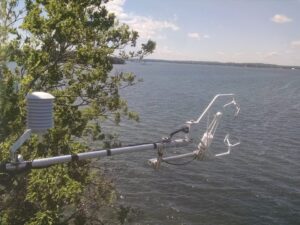
US-Pnp Picnic Point tower
View from top of tower
Keywords: lake flux tower
Location: United States
View in Original Size
To download, right-click photo (Mac: control-click) and choose Save Image As
 US-Pnp
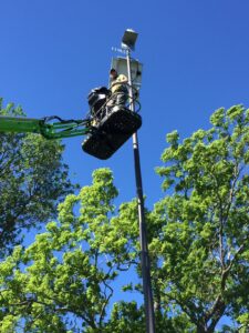
 Picnic Point from below
Looking up at tower installation
Keywords: —
Location: United States
View in Original Size
To download, right-click photo (Mac: control-click) and choose Save Image As
US-Pnp: Lake Mendota, Picnic Point Site
- Overview
- Windroses
- Data Citation
- Data Use Log
- Image Gallery
- Remote Sensing Data
- MODIS
- PhenoCam
- GeoNEX
- Publications
- BADM
| AmeriFlux Publications | Add Publication |
| Year | Publication |
|---|---|
| 2019 | Reed, D. E., Desai, A. R., Whitaker, E. C., Nuckles, H. (2019) Evaluation Of Low-Cost, Automated Lake Ice Thickness Measurements, Journal Of Atmospheric And Oceanic Technology, 36(4), 527-534. https://doi.org/10.1175/JTECH-D-18-0214.1 |
| 2018 | David E. Reed, Hilary A. Dugan, Amelia L. Flannery, Ankur R. Desai (2018) Carbon Sink And Source Dynamics Of A Eutrophic Deep Lake Using Multiple Flux Observations Over Multiple Years, Limnology And Oceanography Letters, . https://doi.org/10.1002/lol2.10075 |
US-Pnp: Lake Mendota, Picnic Point Site
- Overview
- Windroses
- Data Citation
- Data Use Log
- Image Gallery
- Remote Sensing Data
- MODIS
- PhenoCam
- GeoNEX
- Publications
- BADM
BADM for This Site
Access the Biological, Ancillary, Disturbance and Metadata (BADM) information and data for this site.
BADM contain information for many uses, such as characterizing a site’s vegetation and soil, describing disturbance history, and defining instrumentation for flux processing. They complement the flux/met data.
- Download BADM for this site*
- View Site General Info for this site (Overview tab)*
- Use Online Editor to update Site General Info or DOI Authorship
- Update information about submitted data (Variable Information tool)
- More BADM resources
* Online updates are shown on the Overview tab real time. However, downloaded BADM files will not reflect those updates until they have been reviewed for QA/QC.
US-Pnp: Lake Mendota, Picnic Point Site
- Overview
- Windroses
- Data Citation
- Data Use Log
- Image Gallery
- Remote Sensing Data
- MODIS
- PhenoCam
- GeoNEX
- Publications
- BADM
Wind Roses
Wind Speed (m/s)
- Wind Speed Scale: Per Site
- Wind Direction Scale (%): Per Site
- Wind Speed Scale: Non-Linear
- Wind Direction Scale (%): AmeriFlux