
US-YNS: North Star Yedoma
- Overview
- Windroses
- Data Citation
- Data Use Log
- Image Gallery
- Remote Sensing Data
- MODIS
- PhenoCam
- GeoNEX
- Publications
- BADM
| Tower_team: | |
| PI: | Katey Walter Anthony kmwalteranthony@alaska.edu - University of Alaska Fairbanks |
| FluxContact: | Colin Edgar cedgar3@alaska.edu - University of Alaska Fairbanks |
| Lat, Long: | 64.8939, -147.6374 |
| Elevation(m): | 186.9 |
| Network Affiliations: | AmeriFlux |
| Vegetation IGBP: | GRA (Grasslands: Lands with herbaceous types of cover. Tree and shrub cover is less than 10%. Permanent wetlands lands with a permanent mixture of water and herbaceous or woody vegetation. The vegetation can be present in either salt, brackish, or fresh water.) |
| Climate Koeppen: | Dfc (Subarctic: severe winter, no dry season, cool summer) |
| Mean Annual Temp (°C): | -2.5 |
| Mean Annual Precip. (mm): | 275 |
| Flux Species Measured: | CO2, CH4 |
| Years Data Collected: | 2021 - Present |
| Years Data Available: | AmeriFlux BASE 2021 - 2023 Data Citation |
| Data Use Policy: | AmeriFlux Legacy Policy |
| Description: | |
| URL: | — |
| Research Topics: | Upland methane emission, thermokarst GHG, geophysics of permafrost thaw |
| Acknowledgment: | We thank the property owners, Melinda and Roger Evens and Raymond and Stephanie Nadon |
Copyright preference: Open use
US-YNS: North Star Yedoma
- Overview
- Windroses
- Data Citation
- Data Use Log
- Image Gallery
- Remote Sensing Data
- MODIS
- PhenoCam
- GeoNEX
- Publications
- BADM
Use the information below for citation of this site. See the Data Policy page for more details.
DOI(s) for citing US-YNS data
Data Use Policy: AmeriFlux Legacy Policy
- AmeriFlux BASE: https://doi.org/10.17190/AMF/2507523
Citation: Katey Walter Anthony (2025), AmeriFlux BASE US-YNS North Star Yedoma, Ver. 1-5, AmeriFlux AMP, (Dataset). https://doi.org/10.17190/AMF/2507523
To cite BADM when downloaded on their own, use the publications below for citing site characterization. When using BADM that are downloaded with AmeriFlux BASE and AmeriFlux FLUXNET products, use the DOI citation for the associated data product.
Publication(s) for citing site characterization
- —
Acknowledgments
- —
Resources
- AmeriFlux Logos & Acknowledgments
US-YNS: North Star Yedoma
- Overview
- Windroses
- Data Citation
- Data Use Log
- Image Gallery
- Remote Sensing Data
- MODIS
- PhenoCam
- GeoNEX
- Publications
- BADM

This page displays the list of downloads of data for the site {{siteId}}.
Note: Results are the number of downloads to distinct data users. The Download Count column indicates the number of times the data user downloaded the data. The Version column refers to the version of the data product for the site that was downloaded by the data user.
| Date | Name | Data Product | Vers. | Intended Use | Intended Use Description | Download Count |
|---|---|---|---|---|---|---|
| {{dlObject.timeStamp}} | {{dlObject.displayName}} | {{displayProduct(dlObject.dataProduct)}} | {{dlObject.version}} | {{dlObject.intendedUse}} | {{dlObject.comment}} | {{dlObject.downloadCounter}} |
Showing {{startItem + 1}} to {{(startItem + items) > filtered.length ? filtered.length : (startItem + items)}} of {{filtered.length}} results
Showing 0 to 0 of 0 results
Not Found
Uh Oh. Something is missing. Try double checking the URL and try again.
US-YNS: North Star Yedoma
- Overview
- Windroses
- Data Citation
- Data Use Log
- Image Gallery
- Remote Sensing Data
- MODIS
- PhenoCam
- GeoNEX
- Publications
- BADM
| AmeriFlux Images | Add Image |
 US-YNS
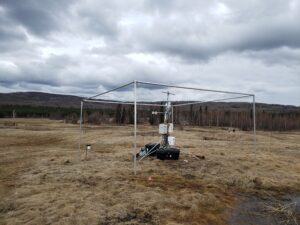
 North Star Yedoma EC tower
Looking North at EC tower and open area that is most of the flux footprint
Keywords: —
Location: Alaska, United States
View in Original Size
To download, right-click photo (Mac: control-click) and choose Save Image As
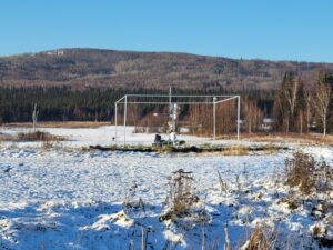
US-YNS North Star Yedoma EC tower 2
Looking East at EC tower in May
Keywords: —
Location: Alaska, United States
View in Original Size
To download, right-click photo (Mac: control-click) and choose Save Image As
US-YNS: North Star Yedoma
- Overview
- Windroses
- Data Citation
- Data Use Log
- Image Gallery
- Remote Sensing Data
- MODIS
- PhenoCam
- GeoNEX
- Publications
- BADM
| AmeriFlux Publications | Add Publication |
| Year | Publication |
|---|---|
| 2024 | Walter Anthony, K. M., Anthony, P., Hasson, N., Edgar, C., Sivan, O., Eliani-Russak, E., Bergman, O., Minsley, B. J., James, S. R., Pastick, N. J., Kholodov, A., Zimov, S., Euskirchen, E., Bret-Harte, M. S., Grosse, G., Langer, M., Nitzbon, J. (2024) Upland Yedoma Taliks Are An Unpredicted Source Of Atmospheric Methane, Nature Communications, 15(1), . https://doi.org/10.1038/s41467-024-50346-5 |
US-YNS: North Star Yedoma
- Overview
- Windroses
- Data Citation
- Data Use Log
- Image Gallery
- Remote Sensing Data
- MODIS
- PhenoCam
- GeoNEX
- Publications
- BADM
BADM for This Site
Access the Biological, Ancillary, Disturbance and Metadata (BADM) information and data for this site.
BADM contain information for many uses, such as characterizing a site’s vegetation and soil, describing disturbance history, and defining instrumentation for flux processing. They complement the flux/met data.
- Download BADM for this site*
- View Site General Info for this site (Overview tab)*
- Use Online Editor to update Site General Info or DOI Authorship
- Update information about submitted data (Variable Information tool)
- More BADM resources
* Online updates are shown on the Overview tab real time. However, downloaded BADM files will not reflect those updates until they have been reviewed for QA/QC.
US-YNS: North Star Yedoma
- Overview
- Windroses
- Data Citation
- Data Use Log
- Image Gallery
- Remote Sensing Data
- MODIS
- PhenoCam
- GeoNEX
- Publications
- BADM