
US-TFF: Thompson Farm Forest
- Overview
- Windroses
- Data Citation
- Data Use Log
- Image Gallery
- Remote Sensing Data
- MODIS
- PhenoCam
- GeoNEX
- Publications
- BADM
| Tower_team: | |
| PI: | Andrew Ouimette Andrew.Ouimette@usda.gov - University of New Hampshire |
| PI: | Scott Ollinger scott.ollinger@unh.edu - University of New Hampshire |
| Technician: | Jack Hastings Jack.Hastings@unh.edu - University of New Hampshire |
| Lat, Long: | 43.1084, -70.9523 |
| Elevation(m): | 23.3 |
| Network Affiliations: | AmeriFlux, Phenocam |
| Vegetation IGBP: | MF (Mixed Forests: Lands dominated by trees with a percent cover >60% and height exceeding 2 meters. Consists of tree communities with interspersed mixtures or mosaics of the other four forest types. None of the forest types exceeds 60% of landscape.) |
| Climate Koeppen: | Dfb (Warm Summer Continental: significant precipitation in all seasons ) |
| Mean Annual Temp (°C): | 8.9 |
| Mean Annual Precip. (mm): | 1170 |
| Flux Species Measured: | CO2, H2O |
| Years Data Collected: | 2014 - Present |
| Years Data Available: | No data available |
| Data Use Policy: | AmeriFlux Legacy Policy |
| Description: | |
| URL: | — |
| Research Topics: | land use-climate interactions, climate effects on carbon cycling |
| Acknowledgment: | This research was supported by the by the NSF Office of Integrated Activities (NSF-OIA--1101245, NSF‐OIA‐1920908) and the USDA National Institute of Food and Agriculture through the New Hampshire Agricultural Experiment Station (USDA‐NIFA 1006997). |
Copyright preference: As long as credit is given
US-TFF: Thompson Farm Forest
- Overview
- Windroses
- Data Citation
- Data Use Log
- Image Gallery
- Remote Sensing Data
- MODIS
- PhenoCam
- GeoNEX
- Publications
- BADM
Use the information below for citation of this site. See the Data Policy page for more details.
DOI(s) for citing US-TFF data
Data Use Policy: AmeriFlux Legacy Policy
- No DOIs available for US-TFF
To cite BADM downloaded as a BIF file, use the publications listed below.
Publication(s) for citing site characterization
- —
Acknowledgments
- —
Resources
- AmeriFlux Logos & Acknowledgments
US-TFF: Thompson Farm Forest
- Overview
- Windroses
- Data Citation
- Data Use Log
- Image Gallery
- Remote Sensing Data
- MODIS
- PhenoCam
- GeoNEX
- Publications
- BADM

This page displays the list of downloads of data for the site {{siteId}}.
Note: Results are the number of downloads to distinct data users. The Download Count column indicates the number of times the data user downloaded the data. The Version column refers to the version of the data product for the site that was downloaded by the data user.
| Date | Name | Data Product | Vers. | Intended Use | Intended Use Description | Download Count |
|---|---|---|---|---|---|---|
| {{dlObject.timeStamp}} | {{dlObject.displayName}} | {{displayProduct(dlObject.dataProduct)}} | {{dlObject.version}} | {{dlObject.intendedUse}} | {{dlObject.comment}} | {{dlObject.downloadCounter}} |
Showing {{startItem + 1}} to {{(startItem + items) > filtered.length ? filtered.length : (startItem + items)}} of {{filtered.length}} results
Showing 0 to 0 of 0 results
Not Found
Uh Oh. Something is missing. Try double checking the URL and try again.
US-TFF: Thompson Farm Forest
- Overview
- Windroses
- Data Citation
- Data Use Log
- Image Gallery
- Remote Sensing Data
- MODIS
- PhenoCam
- GeoNEX
- Publications
- BADM
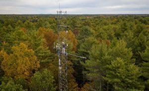
| AmeriFlux Images | Add Image |
US-TFF Thompson Farm Forest tower, NH
Scott Ollinger and Andrew Ouimette working on the TFF tower instruments.
Keywords: Thompson, Forest, climbing, aerial
Location: New Hampshire, United States
View in Original Size
To download, right-click photo (Mac: control-click) and choose Save Image As
US-TFF: Thompson Farm Forest
- Overview
- Windroses
- Data Citation
- Data Use Log
- Image Gallery
- Remote Sensing Data
- MODIS
- PhenoCam
- GeoNEX
- Publications
- BADM
| AmeriFlux Publications | Add Publication |
| Year | Publication |
|---|---|
| 2020 | Sanders‐DeMott, R., Ouimette, A. P., Lepine, L. C., Fogarty, S. Z., Burakowski, E. A., Contosta, A. R., Ollinger, S. V. (2020) Divergent Carbon Cycle Response Of Forest And Grass‐Dominated Northern Temperate Ecosystems To Record Winter Warming, Global Change Biology, 26(3), 1519-1531. https://doi.org/10.1111/gcb.14850 |
| 2018 | Burakowski, E., Tawfik, A., Ouimette, A., Lepine, L., Novick, K., Ollinger, S., Zarzycki, C., Bonan, G. (2018) The Role Of Surface Roughness, Albedo, And Bowen Ratio On Ecosystem Energy Balance In The Eastern United States, Agricultural And Forest Meteorology, 249, 367-376. https://doi.org/10.1016/j.agrformet.2017.11.030 |
US-TFF: Thompson Farm Forest
- Overview
- Windroses
- Data Citation
- Data Use Log
- Image Gallery
- Remote Sensing Data
- MODIS
- PhenoCam
- GeoNEX
- Publications
- BADM
BADM for This Site
Access the Biological, Ancillary, Disturbance and Metadata (BADM) information and data for this site.
BADM contain information for many uses, such as characterizing a site’s vegetation and soil, describing disturbance history, and defining instrumentation for flux processing. They complement the flux/met data.
- Download BADM for this site*
- View Site General Info for this site (Overview tab)*
- Use Online Editor to update Site General Info or DOI Authorship
- Update information about submitted data (Variable Information tool)
- More BADM resources
* Online updates are shown on the Overview tab real time. However, downloaded BADM files will not reflect those updates until they have been reviewed for QA/QC.
US-TFF: Thompson Farm Forest
- Overview
- Windroses
- Data Citation
- Data Use Log
- Image Gallery
- Remote Sensing Data
- MODIS
- PhenoCam
- GeoNEX
- Publications
- BADM