
US-Skr: Shark River Slough (Tower SRS-6) Everglades
- Overview
- Windroses
- Data Citation
- Data Use Log
- Image Gallery
- Remote Sensing Data
- MODIS
- PhenoCam
- GeoNEX
- Publications
- BADM
| Tower_team: | |
| PI: | Sparkle Malone sparkle.malone@yale.edu - Yale University |
| PI: | Tiffany Troxler troxlert@fiu.edu - Florida International University |
| AncContact: | David Reed david.edwin.reed@gmail.com - Yale University |
| Lat, Long: | 25.3629, -81.0776 |
| Elevation(m): | — |
| Network Affiliations: | AmeriFlux, LTER |
| Vegetation IGBP: | EBF (Evergreen Broadleaf Forests: Lands dominated by woody vegetation with a percent cover >60% and height exceeding 2 meters. Almost all trees and shrubs remain green year round. Canopy is never without green foliage.) |
| Climate Koeppen: | Cwa (Humid Subtropical: dry winter, hot summer) |
| Mean Annual Temp (°C): | 23.77 |
| Mean Annual Precip. (mm): | 1259 |
| Flux Species Measured: | CO2, H2O, CH4 |
| Years Data Collected: | 2004 - Present |
| Years Data Available: | AmeriFlux BASE 2004 - 2023 Data Citation |
| Data Use Policy: | AmeriFlux Legacy Policy |
| Description: | |
| URL: | https://fcelter.fiu.edu/ |
| Research Topics: | |
| Acknowledgment: | This material is based upon work supported by the National Science Foundation through the Florida Coastal Everglades Long-Term Ecological Research program under Grant No. DEB-9910514 [for work from 2000-2006], Grant No. DBI-0620409 [for work from 2007-2012], Grant No. DEB-1237517 [for work from Dec. 2012-2018], Grant No. DEB-1832229 [for work from Dec. 2018-Mar. 2021], and Grant No. DEB-2025954 [for work from Mar. 2021-2025]. |
Copyright preference: Request for permission
US-Skr: Shark River Slough (Tower SRS-6) Everglades
- Overview
- Windroses
- Data Citation
- Data Use Log
- Image Gallery
- Remote Sensing Data
- MODIS
- PhenoCam
- GeoNEX
- Publications
- BADM
Use the information below for citation of this site. See the Data Policy page for more details.
DOI(s) for citing US-Skr data
Data Use Policy: AmeriFlux Legacy Policy
- AmeriFlux BASE: https://doi.org/10.17190/AMF/1246105
Citation: Jose Fuentes, Sparkle Malone, Tiffany Troxler (2024), AmeriFlux BASE US-Skr Shark River Slough (Tower SRS-6) Everglades, Ver. 2-5, AmeriFlux AMP, (Dataset). https://doi.org/10.17190/AMF/1246105
To cite BADM when downloaded on their own, use the publications below for citing site characterization. When using BADM that are downloaded with AmeriFlux BASE and AmeriFlux FLUXNET products, use the DOI citation for the associated data product.
Publication(s) for citing site characterization
- —
Acknowledgments
- —
Resources
- AmeriFlux Logos & Acknowledgments
US-Skr: Shark River Slough (Tower SRS-6) Everglades
- Overview
- Windroses
- Data Citation
- Data Use Log
- Image Gallery
- Remote Sensing Data
- MODIS
- PhenoCam
- GeoNEX
- Publications
- BADM

This page displays the list of downloads of data for the site {{siteId}}.
Note: Results are the number of downloads to distinct data users. The Download Count column indicates the number of times the data user downloaded the data. The Version column refers to the version of the data product for the site that was downloaded by the data user.
| Date | Name | Data Product | Vers. | Intended Use | Intended Use Description | Download Count |
|---|---|---|---|---|---|---|
| {{dlObject.timeStamp}} | {{dlObject.displayName}} | {{displayProduct(dlObject.dataProduct)}} | {{dlObject.version}} | {{dlObject.intendedUse}} | {{dlObject.comment}} | {{dlObject.downloadCounter}} |
Showing {{startItem + 1}} to {{(startItem + items) > filtered.length ? filtered.length : (startItem + items)}} of {{filtered.length}} results
Showing 0 to 0 of 0 results
Not Found
Uh Oh. Something is missing. Try double checking the URL and try again.
US-Skr: Shark River Slough (Tower SRS-6) Everglades
- Overview
- Windroses
- Data Citation
- Data Use Log
- Image Gallery
- Remote Sensing Data
- MODIS
- PhenoCam
- GeoNEX
- Publications
- BADM
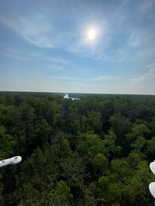
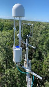
| AmeriFlux Images | Add Image |
 US-Skr
 US-Skr_2
Keywords: —
Location: Florida, United States
View in Original Size
To download, right-click photo (Mac: control-click) and choose Save Image As
US-Skr US-Skr_1
Keywords: —
Location: Florida, United States
View in Original Size
To download, right-click photo (Mac: control-click) and choose Save Image As
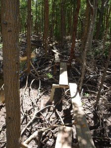 US-Skr
 2008.US.Skr.SitevisitP9240500
2008.US.Skr.SitevisitP9240500
Keywords: —
Location:
View in Original Size
To download, right-click photo (Mac: control-click) and choose Save Image As
US-Skr: Shark River Slough (Tower SRS-6) Everglades
- Overview
- Windroses
- Data Citation
- Data Use Log
- Image Gallery
- Remote Sensing Data
- MODIS
- PhenoCam
- GeoNEX
- Publications
- BADM
| AmeriFlux Publications | Add Publication |
| Year | Publication |
|---|---|
| 2021 | Chu, H., Luo, X., Ouyang, Z., Chan, W. S., Dengel, S., Biraud, S. C., Torn, M. S., Metzger, S., Kumar, J., Arain, M. A., Arkebauer, T. J., Baldocchi, D., Bernacchi, C., Billesbach, D., Black, T. A., Blanken, P. D., Bohrer, G., Bracho, R., Brown, S., Brunsell, N. A., Chen, J., Chen, X., Clark, K., Desai, A. R., Duman, T., Durden, D., Fares, S., Forbrich, I., Gamon, J. A., Gough, C. M., Griffis, T., Helbig, M., Hollinger, D., Humphreys, E., Ikawa, H., Iwata, H., Ju, Y., Knowles, J. F., Knox, S. H., Kobayashi, H., Kolb, T., Law, B., Lee, X., Litvak, M., Liu, H., Munger, J. W., Noormets, A., Novick, K., Oberbauer, S. F., Oechel, W., Oikawa, P., Papuga, S. A., Pendall, E., Prajapati, P., Prueger, J., Quinton, W. L., Richardson, A. D., Russell, E. S., Scott, R. L., Starr, G., Staebler, R., Stoy, P. C., Stuart-Haëntjens, E., Sonnentag, O., Sullivan, R. C., Suyker, A., Ueyama, M., Vargas, R., Wood, J. D., Zona, D. (2021) Representativeness Of Eddy-Covariance Flux Footprints For Areas Surrounding Ameriflux Sites, Agricultural And Forest Meteorology, 301-302, 108350. https://doi.org/10.1016/j.agrformet.2021.108350 |
| 2020 | Feagin, R. A., Forbrich, I., Huff, T. P., Barr, J. G., Ruiz‐Plancarte, J., Fuentes, J. D., Najjar, R. G., Vargas, R., Vázquez‐Lule, A., Windham‐Myers, L., Kroeger, K. D., Ward, E. J., Moore, G. W., Leclerc, M., Krauss, K. W., Stagg, C. L., Alber, M., Knox, S. H., Schäfer, K. V., Bianchi, T. S., Hutchings, J. A., Nahrawi, H., Noormets, A., Mitra, B., Jaimes, A., Hinson, A. L., Bergamaschi, B., King, J. S., Miao, G. (2020) Tidal Wetland Gross Primary Production Across The Continental United States, 2000–2019, Global Biogeochemical Cycles, 34(2), . https://doi.org/10.1029/2019GB006349 |
| 2018 | Chu, H., Baldocchi, D. D., Poindexter, C., Abraha, M., Desai, A. R., Bohrer, G., Arain, M. A., Griffis, T., Blanken, P. D., O'Halloran, T. L., Thomas, R. Q., Zhang, Q., Burns, S. P., Frank, J. M., Christian, D., Brown, S., Black, T. A., Gough, C. M., Law, B. E., Lee, X., Chen, J., Reed, D. E., Massman, W. J., Clark, K., Hatfield, J., Prueger, J., Bracho, R., Baker, J. M., Martin, T. A. (2018) Temporal Dynamics Of Aerodynamic Canopy Height Derived From Eddy Covariance Momentum Flux Data Across North American Flux Networks, Geophysical Research Letters, 45, 9275–9287. https://doi.org/10.1029/2018GL079306 |
| 2013 | Barr, J. G., Engel, V., Fuentes, J. D., Fuller, D. O., Kwon, H. (2013) Modeling Light Use Efficiency In A Subtropical Mangrove Forest Equipped With Co2 Eddy Covariance, Biogeosciences, 10(3), 2145-2158. https://doi.org/10.5194/bg-10-2145-2013 |
| 2010 | Barr, J. G., Engel, V., Fuentes, J. D., Zieman, J. C., O'Halloran, T. L., Smith, T. J., Anderson, G. H. (2010) Controls On Mangrove Forest-Atmosphere Carbon Dioxide Exchanges In Western Everglades National Park, Journal Of Geophysical Research: Biogeosciences, 115(G2), n/a-n/a. https://doi.org/10.1029/2009JG001186 |
| 2012 | Barr, J. G., Engel, V., Smith, T. J., Fuentes, J. D. (2012) Hurricane Disturbance And Recovery Of Energy Balance, CO2 Fluxes And Canopy Structure In A Mangrove Forest Of The Florida Everglades, Agricultural And Forest Meteorology, 153, 54-66. https://doi.org/10.1016/j.agrformet.2011.07.022 |
| 2009 | Barr, J. G., Fuentes, J. D., Engel, V., Zieman, J. C. (2009) Physiological Responses Of Red Mangroves To The Climate In The Florida Everglades, Journal Of Geophysical Research: Biogeosciences, 114(G02008), n/a-n/a. https://doi.org/10.1029/2008JG000843 |
US-Skr: Shark River Slough (Tower SRS-6) Everglades
- Overview
- Windroses
- Data Citation
- Data Use Log
- Image Gallery
- Remote Sensing Data
- MODIS
- PhenoCam
- GeoNEX
- Publications
- BADM
BADM for This Site
Access the Biological, Ancillary, Disturbance and Metadata (BADM) information and data for this site.
BADM contain information for many uses, such as characterizing a site’s vegetation and soil, describing disturbance history, and defining instrumentation for flux processing. They complement the flux/met data.
- Download BADM for this site*
- View Site General Info for this site (Overview tab)*
- Use Online Editor to update Site General Info or DOI Authorship
- Update information about submitted data (Variable Information tool)
- More BADM resources
* Online updates are shown on the Overview tab real time. However, downloaded BADM files will not reflect those updates until they have been reviewed for QA/QC.
US-Skr: Shark River Slough (Tower SRS-6) Everglades
- Overview
- Windroses
- Data Citation
- Data Use Log
- Image Gallery
- Remote Sensing Data
- MODIS
- PhenoCam
- GeoNEX
- Publications
- BADM
Wind Roses
Wind Speed (m/s)
- Wind Speed Scale: Per Site
- Wind Direction Scale (%): Per Site
- Wind Speed Scale: Non-Linear
- Wind Direction Scale (%): AmeriFlux