
US-SO2: Sky Oaks- Old Stand
- Overview
- Windroses
- Data Citation
- Data Use Log
- Image Gallery
- Remote Sensing Data
- MODIS
- PhenoCam
- GeoNEX
- Publications
- BADM
| Tower_team: | |
| PI: | Walt Oechel woechel@mail.sdsu.edu - San Diego State University |
| Lat, Long: | 33.3738, -116.6228 |
| Elevation(m): | 1394.00 |
| Network Affiliations: | AmeriFlux |
| Vegetation IGBP: | CSH (Closed Shrublands: Lands with woody vegetation less than 2 meters tall and with shrub canopy cover >60%. The shrub foliage can be either evergreen or deciduous.) |
| Climate Koeppen: | Csa (Mediterranean: mild with dry, hot summer) |
| Mean Annual Temp (°C): | 13.63 |
| Mean Annual Precip. (mm): | 553 |
| Flux Species Measured: | CO2, H2O |
| Years Data Collected: | 1997 - Present |
| Years Data Available: | AmeriFlux BASE 1997 - 2006 Data Citation |
| Data Use Policy: | AmeriFlux Legacy Policy |
| Description: | |
| URL: | http://gcrg.sdsu.edu |
| Research Topics: | |
| Acknowledgment: | — |
Copyright preference: Request for permission
US-SO2: Sky Oaks- Old Stand
- Overview
- Windroses
- Data Citation
- Data Use Log
- Image Gallery
- Remote Sensing Data
- MODIS
- PhenoCam
- GeoNEX
- Publications
- BADM
Use the information below for citation of this site. See the Data Policy page for more details.
DOI(s) for citing US-SO2 data
Data Use Policy: AmeriFlux Legacy Policy
- AmeriFlux BASE: https://doi.org/10.17190/AMF/1246097
Citation: Walt Oechel (2016), AmeriFlux BASE US-SO2 Sky Oaks- Old Stand, Ver. 1-1, AmeriFlux AMP, (Dataset). https://doi.org/10.17190/AMF/1246097
To cite BADM when downloaded on their own, use the publications below for citing site characterization. When using BADM that are downloaded with AmeriFlux BASE and AmeriFlux FLUXNET products, use the DOI citation for the associated data product.
Publication(s) for citing site characterization
- —
Acknowledgments
- —
Resources
- AmeriFlux Logos & Acknowledgments
US-SO2: Sky Oaks- Old Stand
- Overview
- Windroses
- Data Citation
- Data Use Log
- Image Gallery
- Remote Sensing Data
- MODIS
- PhenoCam
- GeoNEX
- Publications
- BADM

This page displays the list of downloads of data for the site {{siteId}}.
Note: Results are the number of downloads to distinct data users. The Download Count column indicates the number of times the data user downloaded the data. The Version column refers to the version of the data product for the site that was downloaded by the data user.
| Date | Name | Data Product | Vers. | Intended Use | Intended Use Description | Download Count |
|---|---|---|---|---|---|---|
| {{dlObject.timeStamp}} | {{dlObject.displayName}} | {{displayProduct(dlObject.dataProduct)}} | {{dlObject.version}} | {{dlObject.intendedUse}} | {{dlObject.comment}} | {{dlObject.downloadCounter}} |
Showing {{startItem + 1}} to {{(startItem + items) > filtered.length ? filtered.length : (startItem + items)}} of {{filtered.length}} results
Showing 0 to 0 of 0 results
Not Found
Uh Oh. Something is missing. Try double checking the URL and try again.
US-SO2: Sky Oaks- Old Stand
- Overview
- Windroses
- Data Citation
- Data Use Log
- Image Gallery
- Remote Sensing Data
- MODIS
- PhenoCam
- GeoNEX
- Publications
- BADM
| AmeriFlux Images | Add Image |
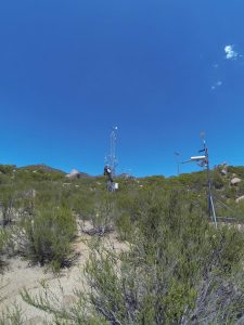
 US-SO2
 2008.US.SO2.Sitevisit101 003
2008.US.SO2.Sitevisit101 003
Keywords: —
Location:
View in Original Size
To download, right-click photo (Mac: control-click) and choose Save Image As
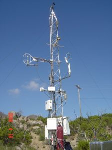
 US-SO2
 2017.US-So2.sitevisit.IMAG8558
2017.US-So2.sitevisit.IMAG8558
Keywords: —
Location:
View in Original Size
To download, right-click photo (Mac: control-click) and choose Save Image As
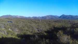
 US-SO2
 2017.US-So2.sitevisit.IMAG8575
2017.US-So2.sitevisit.IMAG8575
Keywords: —
Location:
View in Original Size
To download, right-click photo (Mac: control-click) and choose Save Image As
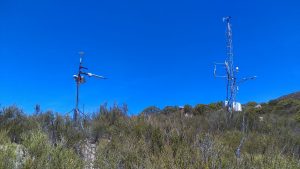
US-SO2 2017.US-So2.sitevisit.GOPR2375
2017.US-So2.sitevisit.GOPR2375
Keywords: —
Location:
View in Original Size
To download, right-click photo (Mac: control-click) and choose Save Image As
US-SO2: Sky Oaks- Old Stand
- Overview
- Windroses
- Data Citation
- Data Use Log
- Image Gallery
- Remote Sensing Data
- MODIS
- PhenoCam
- GeoNEX
- Publications
- BADM
| AmeriFlux Publications | Add Publication |
| Year | Publication |
|---|---|
| 2021 | Chu, H., Luo, X., Ouyang, Z., Chan, W. S., Dengel, S., Biraud, S. C., Torn, M. S., Metzger, S., Kumar, J., Arain, M. A., Arkebauer, T. J., Baldocchi, D., Bernacchi, C., Billesbach, D., Black, T. A., Blanken, P. D., Bohrer, G., Bracho, R., Brown, S., Brunsell, N. A., Chen, J., Chen, X., Clark, K., Desai, A. R., Duman, T., Durden, D., Fares, S., Forbrich, I., Gamon, J. A., Gough, C. M., Griffis, T., Helbig, M., Hollinger, D., Humphreys, E., Ikawa, H., Iwata, H., Ju, Y., Knowles, J. F., Knox, S. H., Kobayashi, H., Kolb, T., Law, B., Lee, X., Litvak, M., Liu, H., Munger, J. W., Noormets, A., Novick, K., Oberbauer, S. F., Oechel, W., Oikawa, P., Papuga, S. A., Pendall, E., Prajapati, P., Prueger, J., Quinton, W. L., Richardson, A. D., Russell, E. S., Scott, R. L., Starr, G., Staebler, R., Stoy, P. C., Stuart-Haëntjens, E., Sonnentag, O., Sullivan, R. C., Suyker, A., Ueyama, M., Vargas, R., Wood, J. D., Zona, D. (2021) Representativeness Of Eddy-Covariance Flux Footprints For Areas Surrounding Ameriflux Sites, Agricultural And Forest Meteorology, 301-302, 108350. https://doi.org/10.1016/j.agrformet.2021.108350 |
| 2013 | Barr, A., Richardson, A., Hollinger, D., Papale, D., Arain, M., Black, T., Bohrer, G., Dragoni, D., Fischer, M., Gu, L., Law, B., Margolis, H., McCaughey, J., Munger, J., Oechel, W., Schaeffer, K. (2013) Use Of Change-Point Detection For Friction–Velocity Threshold Evaluation In Eddy-Covariance Studies, Agricultural And Forest Meteorology, 171-172, 31-45. https://doi.org/10.1016/j.agrformet.2012.11.023 |
| 2015 | Dennis Baldocchi, Cove Sturtevant (2015) Does day and night sampling reduce spurious correlation between canopy photosynthesis and ecosystem respiration?, Agricultural and Forest Meteorology, 207, 117-126. https://doi.org/10.1016/j.agrformet.2015.03.010 |
| 2002 | Stylinski, C. D., Gamon, J. A., Oechel, W. C. (2002) Seasonal Patterns Of Reflectance Indices, Carotenoid Pigments And Photosynthesis Of Evergreen Chaparral Species, Oecologia, 131(3), 366-374. https://doi.org/10.1007/s00442-002-0905-9 |
| 2005 | Lipson, D. A., Wilson, R. F., Oechel, W. C. (2005) Effects Of Elevated Atmospheric CO2 On Soil Microbial Biomass, Activity, And Diversity In A Chaparral Ecosystem, Applied And Environmental Microbiology, 71(12), 8573-8580. https://doi.org/10.1128/aem.71.12.8573-8580.2005 |
| 2007 | Luo, H., Oechel, W. C., Hastings, S. J., Zulueta, R., Qian, Y., Kwon, H. (2007) Mature Semiarid Chaparral Ecosystems Can Be A Significant Sink For Atmospheric Carbon Dioxide, Global Change Biology, 13(2), 386-396. https://doi.org/10.1111/j.1365-2486.2006.01299.x |
US-SO2: Sky Oaks- Old Stand
- Overview
- Windroses
- Data Citation
- Data Use Log
- Image Gallery
- Remote Sensing Data
- MODIS
- PhenoCam
- GeoNEX
- Publications
- BADM
BADM for This Site
Access the Biological, Ancillary, Disturbance and Metadata (BADM) information and data for this site.
BADM contain information for many uses, such as characterizing a site’s vegetation and soil, describing disturbance history, and defining instrumentation for flux processing. They complement the flux/met data.
- Download BADM for this site*
- View Site General Info for this site (Overview tab)*
- Use Online Editor to update Site General Info or DOI Authorship
- Update information about submitted data (Variable Information tool)
- More BADM resources
* Online updates are shown on the Overview tab real time. However, downloaded BADM files will not reflect those updates until they have been reviewed for QA/QC.
US-SO2: Sky Oaks- Old Stand
- Overview
- Windroses
- Data Citation
- Data Use Log
- Image Gallery
- Remote Sensing Data
- MODIS
- PhenoCam
- GeoNEX
- Publications
- BADM
Wind Roses
Wind Speed (m/s)
- Wind Speed Scale: Per Site
- Wind Direction Scale (%): Per Site
- Wind Speed Scale: Non-Linear
- Wind Direction Scale (%): AmeriFlux