
US-SB1: Sweet Briar Land-Atmosphere Research Station
- Overview
- Windroses
- Data Citation
- Data Use Log
- Image Gallery
- Remote Sensing Data
- MODIS
- PhenoCam
- GeoNEX
- Publications
- BADM
| Tower_team: | |
| PI: | R. Quinn Thomas rqthomas@vt.edu - Virginia Tech |
| PI: | Tom O'Halloran tohallo@clemson.edu - Clemson University |
| DataManager: | Haoyu Li haoyul@clemson.edu - Clemson University |
| DataManager: | Jeremy Forsythe jdforsy@g.clemson.edu - Clemson University |
| Lat, Long: | 37.5734, -79.0848 |
| Elevation(m): | 242 |
| Network Affiliations: | AmeriFlux, Phenocam |
| Vegetation IGBP: | ENF (Evergreen Needleleaf Forests: Lands dominated by woody vegetation with a percent cover >60% and height exceeding 2 meters. Almost all trees remain green all year. Canopy is never without green foliage.) |
| Climate Koeppen: | Cfa (Humid Subtropical: mild with no dry season, hot summer) |
| Mean Annual Temp (°C): | 12.7 |
| Mean Annual Precip. (mm): | 1016 |
| Flux Species Measured: | CO2, H2O |
| Years Data Collected: | 2015 - 2024 |
| Years Data Available: | AmeriFlux BASE 2015 - 2024 Data Citation |
| Data Use Policy: | AmeriFlux CC-BY-4.0 Policy1 |
| Description: | |
| URL: | http://sbc-lars.blog.sbc.edu/ |
| Research Topics: | carbon cycling, biogeophysics, forestry, biofuels, biogenic aerosols, diffuse light |
| Acknowledgment: | The Thomas F. and Kate Miller Jeffress Memorial Trust, Bank of America, Trustee |
| USDA-NIFA Project 2015-67003-23485 | |
| USDA-NIFA Project 2017-68002-26612 | |
| USDA-NIFA Project 2022-67019-36304 | |
| Virginia Tech Fralin Life Sciences Institute | |
| Virginia Tech Global Change Center |
- This site’s data can also be used under the more restrictive AmeriFlux Legacy Policy.
The AmeriFlux Legacy Policy must be followed if this site’s data are combined with data from sites that require the AmeriFlux Legacy Policy.
Copyright preference: As long as credit is given
US-SB1: Sweet Briar Land-Atmosphere Research Station
- Overview
- Windroses
- Data Citation
- Data Use Log
- Image Gallery
- Remote Sensing Data
- MODIS
- PhenoCam
- GeoNEX
- Publications
- BADM
Use the information below for citation of this site. See the Data Policy page for more details.
DOI(s) for citing US-SB1 data
Data Use Policy: AmeriFlux CC-BY-4.0 License
This site’s data can also be used under the more restrictive AmeriFlux Legacy Policy.
The AmeriFlux Legacy Policy must be followed if US-SB1 data are combined with data from sites that require the AmeriFlux Legacy Policy.
- AmeriFlux BASE: https://doi.org/10.17190/AMF/3015325
Citation: Benjamin Ahlswede, Haoyu Li, Jeremy Forsythe, Jim LeMoine, Jordan Barr, Mike Kline, R.Quinn Thomas, Thomas O'Halloran, Verena Joerger (2026), AmeriFlux BASE US-SB1 Sweet Briar Land-Atmosphere Research Station, Ver. 1-5, AmeriFlux AMP, (Dataset). https://doi.org/10.17190/AMF/3015325
To cite BADM when downloaded on their own, use the publications below for citing site characterization. When using BADM that are downloaded with AmeriFlux BASE and AmeriFlux FLUXNET products, use the DOI citation for the associated data product.
Publication(s) for citing site characterization
- —
Acknowledgments
- —
Resources
- AmeriFlux Logos & Acknowledgments
US-SB1: Sweet Briar Land-Atmosphere Research Station
- Overview
- Windroses
- Data Citation
- Data Use Log
- Image Gallery
- Remote Sensing Data
- MODIS
- PhenoCam
- GeoNEX
- Publications
- BADM

This page displays the list of downloads of data for the site {{siteId}}.
Note: Results are the number of downloads to distinct data users. The Download Count column indicates the number of times the data user downloaded the data. The Version column refers to the version of the data product for the site that was downloaded by the data user.
| Date | Name | Data Product | Vers. | Intended Use | Intended Use Description | Download Count |
|---|---|---|---|---|---|---|
| {{dlObject.timeStamp}} | {{dlObject.displayName}} | {{displayProduct(dlObject.dataProduct)}} | {{dlObject.version}} | {{dlObject.intendedUse}} | {{dlObject.comment}} | {{dlObject.downloadCounter}} |
Showing {{startItem + 1}} to {{(startItem + items) > filtered.length ? filtered.length : (startItem + items)}} of {{filtered.length}} results
Showing 0 to 0 of 0 results
Not Found
Uh Oh. Something is missing. Try double checking the URL and try again.
US-SB1: Sweet Briar Land-Atmosphere Research Station
- Overview
- Windroses
- Data Citation
- Data Use Log
- Image Gallery
- Remote Sensing Data
- MODIS
- PhenoCam
- GeoNEX
- Publications
- BADM
| AmeriFlux Images | Add Image |
 US-SB1
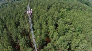
 US-SB1.sitevisit.IMG_6761
US-SB1.sitevisit.IMG_6761
Keywords: —
Location:
View in Original Size
To download, right-click photo (Mac: control-click) and choose Save Image As
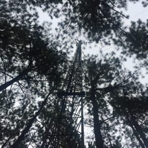
US-SB1 US-SB1 Sweet Briar Loblolly Pine
Keywords: Sweet Briar loblolly pine tower
Location: United States
View in Original Size
To download, right-click photo (Mac: control-click) and choose Save Image As
US-SB1: Sweet Briar Land-Atmosphere Research Station
- Overview
- Windroses
- Data Citation
- Data Use Log
- Image Gallery
- Remote Sensing Data
- MODIS
- PhenoCam
- GeoNEX
- Publications
- BADM
MODIS NDVI
The time series shows the 16-day Normalized Difference Vegetation Index (NDVI) average from the MOD13Q1 data product.
Use the slider below the time series to zoom in and out.
To view / download these data and other MOD13Q1 products for this site, visit MODIS/Terra Vegetation Indices.
For other related products, visit MODIS/VIIRS Fixed Sites Subsets Tool.
Citation:
ORNL DAAC. 2018. Terrestrial Ecology Subsetting & Visualization Services (TESViS) Fixed Sites Subsets. ORNL DAAC, Oak Ridge, Tennessee, USA. https://doi.org/10.3334/ORNLDAAC/1567
MODIS NDVI subsetted data is not yet available for this site.
For a complete list of AmeriFlux sites, visit ORNL DAAC's MODIS/VIIRS Fixed Sites Subsets Tool.


US-SB1: Sweet Briar Land-Atmosphere Research Station
- Overview
- Windroses
- Data Citation
- Data Use Log
- Image Gallery
- Remote Sensing Data
- MODIS
- PhenoCam
- GeoNEX
- Publications
- BADM
| AmeriFlux Publications | Add Publication |
| Year | Publication |
|---|---|
| 2022 | Ahlswede, B. J., O'Halloran, T. L., Thomas, R. Q. (2022) Combined Carbon And Albedo Climate Forcing From Pine And Switchgrass Grown For Bioenergy, Frontiers In Forests And Global Change, 5, . https://doi.org/10.3389/ffgc.2022.774067 |
| 2018 | Chu, H., Baldocchi, D. D., Poindexter, C., Abraha, M., Desai, A. R., Bohrer, G., Arain, M. A., Griffis, T., Blanken, P. D., O'Halloran, T. L., Thomas, R. Q., Zhang, Q., Burns, S. P., Frank, J. M., Christian, D., Brown, S., Black, T. A., Gough, C. M., Law, B. E., Lee, X., Chen, J., Reed, D. E., Massman, W. J., Clark, K., Hatfield, J., Prueger, J., Bracho, R., Baker, J. M., Martin, T. A. (2018) Temporal Dynamics Of Aerodynamic Canopy Height Derived From Eddy Covariance Momentum Flux Data Across North American Flux Networks, Geophysical Research Letters, 45, 9275–9287. https://doi.org/10.1029/2018GL079306 |
US-SB1: Sweet Briar Land-Atmosphere Research Station
- Overview
- Windroses
- Data Citation
- Data Use Log
- Image Gallery
- Remote Sensing Data
- MODIS
- PhenoCam
- GeoNEX
- Publications
- BADM
BADM for This Site
Access the Biological, Ancillary, Disturbance and Metadata (BADM) information and data for this site.
BADM contain information for many uses, such as characterizing a site’s vegetation and soil, describing disturbance history, and defining instrumentation for flux processing. They complement the flux/met data.
- Download BADM for this site*
- View Site General Info for this site (Overview tab)*
- Use Online Editor to update Site General Info or DOI Authorship
- Update information about submitted data (Variable Information tool)
- More BADM resources
* Online updates are shown on the Overview tab real time. However, downloaded BADM files will not reflect those updates until they have been reviewed for QA/QC.
US-SB1: Sweet Briar Land-Atmosphere Research Station
- Overview
- Windroses
- Data Citation
- Data Use Log
- Image Gallery
- Remote Sensing Data
- MODIS
- PhenoCam
- GeoNEX
- Publications
- BADM