
US-Rwf: RCEW Upper Sheep Prescibed Fire
- Overview
- Windroses
- Data Citation
- Data Use Log
- Image Gallery
- Remote Sensing Data
- MODIS
- PhenoCam
- GeoNEX
- Publications
- BADM
| Tower_team: | |
| PI: | Gerald Flerchinger gerald.flerchinger@usda.gov - USDA Agricultural Research Service |
| Lat, Long: | 43.1207, -116.7231 |
| Elevation(m): | 1878 |
| Network Affiliations: | AmeriFlux, LTAR |
| Vegetation IGBP: | CSH (Closed Shrublands: Lands with woody vegetation less than 2 meters tall and with shrub canopy cover >60%. The shrub foliage can be either evergreen or deciduous.) |
| Climate Koeppen: | Bsh (Steppe: very cold winter) |
| Mean Annual Temp (°C): | 6.5 |
| Mean Annual Precip. (mm): | 505 |
| Flux Species Measured: | CO2 |
| Years Data Collected: | 2014 - Present |
| Years Data Available: | AmeriFlux BASE 2014 - 2023 Data Citation AmeriFlux FLUXNET 2014 - 2023 Data Citation |
| Data Use Policy: | AmeriFlux CC-BY-4.0 Policy1 |
| Description: | |
| URL: | — |
| Research Topics: | Post-fire ecosystem recovery and productivity |
| Acknowledgment: | Support for the Reynolds Creek Critical Zone Observatory Cooperative is provided by USDA ARS and NSF Grant #EAR 1331872. |
- This site’s data can also be used under the more restrictive AmeriFlux Legacy Policy.
The AmeriFlux Legacy Policy must be followed if this site’s data are combined with data from sites that require the AmeriFlux Legacy Policy.
Copyright preference: Open use
US-Rwf: RCEW Upper Sheep Prescibed Fire
- Overview
- Windroses
- Data Citation
- Data Use Log
- Image Gallery
- Remote Sensing Data
- MODIS
- PhenoCam
- GeoNEX
- Publications
- BADM
Use the information below for citation of this site. See the Data Policy page for more details.
DOI(s) for citing US-Rwf data
Data Use Policy: AmeriFlux CC-BY-4.0 License
This site’s data can also be used under the more restrictive AmeriFlux Legacy Policy.
The AmeriFlux Legacy Policy must be followed if US-Rwf data are combined with data from sites that require the AmeriFlux Legacy Policy.
- AmeriFlux BASE: https://doi.org/10.17190/AMF/1617724
Citation: Gerald Flerchinger (2025), AmeriFlux BASE US-Rwf RCEW Upper Sheep Prescibed Fire, Ver. 5-5, AmeriFlux AMP, (Dataset). https://doi.org/10.17190/AMF/1617724 - AmeriFlux FLUXNET: https://doi.org/10.17190/AMF/1881591
Citation: Gerald Flerchinger (2026), AmeriFlux FLUXNET-1F US-Rwf RCEW Upper Sheep Prescibed Fire, Ver. v1.3_r1, AmeriFlux AMP, (Dataset). https://doi.org/10.17190/AMF/1881591
Find global FLUXNET datasets, like FLUXNET2015 and FLUXNET-CH4, and their citation information at fluxnet.org.
To cite BADM when downloaded on their own, use the publications below for citing site characterization. When using BADM that are downloaded with AmeriFlux BASE and AmeriFlux FLUXNET products, use the DOI citation for the associated data product.
Publication(s) for citing site characterization
- —
Acknowledgments
- —
Resources
- AmeriFlux Logos & Acknowledgments
US-Rwf: RCEW Upper Sheep Prescibed Fire
- Overview
- Windroses
- Data Citation
- Data Use Log
- Image Gallery
- Remote Sensing Data
- MODIS
- PhenoCam
- GeoNEX
- Publications
- BADM

This page displays the list of downloads of data for the site {{siteId}}.
Note: Results are the number of downloads to distinct data users. The Download Count column indicates the number of times the data user downloaded the data. The Version column refers to the version of the data product for the site that was downloaded by the data user.
| Date | Name | Data Product | Vers. | Intended Use | Intended Use Description | Download Count |
|---|---|---|---|---|---|---|
| {{dlObject.timeStamp}} | {{dlObject.displayName}} | {{displayProduct(dlObject.dataProduct)}} | {{dlObject.version}} | {{dlObject.intendedUse}} | {{dlObject.comment}} | {{dlObject.downloadCounter}} |
Showing {{startItem + 1}} to {{(startItem + items) > filtered.length ? filtered.length : (startItem + items)}} of {{filtered.length}} results
Showing 0 to 0 of 0 results
Not Found
Uh Oh. Something is missing. Try double checking the URL and try again.
US-Rwf: RCEW Upper Sheep Prescibed Fire
- Overview
- Windroses
- Data Citation
- Data Use Log
- Image Gallery
- Remote Sensing Data
- MODIS
- PhenoCam
- GeoNEX
- Publications
- BADM
| AmeriFlux Images | Add Image |
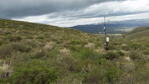
US-Rwf Upper Sheep Post-fire recovery
View looking to the northwest at the target vegetation. Photo was take 10.5 years after a prescribed fire in 2007.
Keywords: —
Location: United States
View in Original Size
To download, right-click photo (Mac: control-click) and choose Save Image As
 US-Rwf
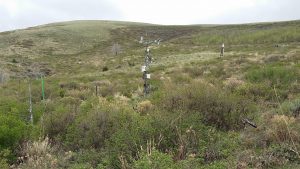
 Upper Sheep Post-fire recovery
View looking to the southeast upward into the catchment. Photo was take 10.5 years after a prescribed fire in 2007.
Keywords: —
Location: Idaho, United States
View in Original Size
To download, right-click photo (Mac: control-click) and choose Save Image As
 US-Rwf
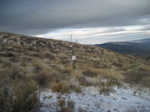
 Upper Sheep Post-fire recovery
View looking to the northwest at the target vegetation. Photo was take 8 years after a prescribed fire in 2007.
Keywords: —
Location: Idaho, United States
View in Original Size
To download, right-click photo (Mac: control-click) and choose Save Image As
 US-Rwf
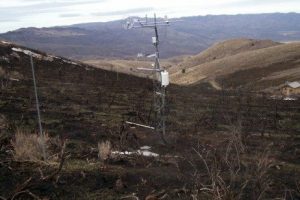
 Upper Sheep Immediately Post-fire
Photo taken soon after prescribed fire conduced in September 2007
Keywords: prescribed fire
Location: Idaho, United States
View in Original Size
To download, right-click photo (Mac: control-click) and choose Save Image As
US-Rwf: RCEW Upper Sheep Prescibed Fire
- Overview
- Windroses
- Data Citation
- Data Use Log
- Image Gallery
- Remote Sensing Data
- MODIS
- PhenoCam
- GeoNEX
- Publications
- BADM
| AmeriFlux Publications | Add Publication |
| Year | Publication |
|---|---|
| 2025 | Xia, Y., Sanderman, J., Watts, J. D., Machmuller, M. B., Mullen, A. L., Rivard, C., Endsley, A., Hernandez, H., Kimball, J., Ewing, S. A., Litvak, M., Duman, T., Krishnan, P., Meyers, T., Brunsell, N. A., Mohanty, B., Liu, H., Gao, Z., Chen, J., Abraha, M., Scott, R. L., Flerchinger, G. N., Clark, P. E., Stoy, P. C., Khan, A. M., Brookshire, E. N., Zhang, Q., Cook, D. R., Thienelt, T., Mitra, B., Mauritz‐Tozer, M., Tweedie, C. E., Torn, M. S., Billesbach, D. (2025) Coupling Remote Sensing With A Process Model For The Simulation Of Rangeland Carbon Dynamics, Journal Of Advances In Modeling Earth Systems, 17(3), . https://doi.org/10.1029/2024MS004342 |
| 2014 | Flerchinger, G., Seyfried, M. (2014) Comparison Of Methods For Estimating Evapotranspiration In A Small Rangeland Catchment, Vadose Zone Journal, 13(4), vzj2013.08.0152. https://doi.org/doi:10.2136/vzj2013.08.0152 |
| 2016 | Flerchinger, G. N., Seyfried, M. S., Hardegree, S. P. (2016) Hydrologic Response And Recovery To Prescribed Fire And Vegetation Removal In A Small Rangeland Catchment, Ecohydrology, 9(8), 1604-1619. https://doi.org/DOI:10.1002/eco.1751 |
| 2020 | Flerchinger, G. N., Fellows, A. W., Seyfried, M. S., Clark, P. E., Lohse, K. A. (2020) Water And Carbon Fluxes Along An Elevational Gradient In A Sagebrush Ecosystem, Ecosystems, 23(2), 246-263. https://doi.org/https://doi.org/10.1007/s10021-019-00400-x |
| 2018 | Fellows, A. W., Flerchinger, G. N., Lohse, K. A., Seyfried, M. S. (2018) Rapid Recovery Of Gross Production And Respiration In A Mesic Mountain Big Sagebrush Ecosystem Following Prescribed Fire, Ecosystems, 21(7), 1283-1294. https://doi.org/https://doi.org/10.1007/s10021-017-0218-9 |
| 2020 | Fellows, A. W., Flerchinger, G. N., Seyfried, M. S., Biederman, J. A., Lohse, K. A. (2020) Winter Co 2 Efflux From Sagebrush Shrublands Distributed Across The Rain‐To‐Snow Transition Zone, Journal Of Geophysical Research: Biogeosciences, 125(2), . https://doi.org/https://doi.org/10.1029/2019JG005325 |
| 2019 | Flerchinger, G. N., Fellows, A. W., Seyfried, M. S., Clark, P. E., Lohse, K. A. (2019) Water And Carbon Fluxes Along An Elevational Gradient In A Sagebrush Ecosystem, Ecosystems, . https://doi.org/10.1007/s10021-019-00400-x |
US-Rwf: RCEW Upper Sheep Prescibed Fire
- Overview
- Windroses
- Data Citation
- Data Use Log
- Image Gallery
- Remote Sensing Data
- MODIS
- PhenoCam
- GeoNEX
- Publications
- BADM
BADM for This Site
Access the Biological, Ancillary, Disturbance and Metadata (BADM) information and data for this site.
BADM contain information for many uses, such as characterizing a site’s vegetation and soil, describing disturbance history, and defining instrumentation for flux processing. They complement the flux/met data.
- Download BADM for this site*
- View Site General Info for this site (Overview tab)*
- Use Online Editor to update Site General Info or DOI Authorship
- Update information about submitted data (Variable Information tool)
- More BADM resources
* Online updates are shown on the Overview tab real time. However, downloaded BADM files will not reflect those updates until they have been reviewed for QA/QC.
US-Rwf: RCEW Upper Sheep Prescibed Fire
- Overview
- Windroses
- Data Citation
- Data Use Log
- Image Gallery
- Remote Sensing Data
- MODIS
- PhenoCam
- GeoNEX
- Publications
- BADM
Wind Roses
Wind Speed (m/s)
- Wind Speed Scale: Per Site
- Wind Direction Scale (%): Per Site
- Wind Speed Scale: Non-Linear
- Wind Direction Scale (%): AmeriFlux