
US-RGB: Butte County Rice Farm
- Overview
- Windroses
- Data Citation
- Data Use Log
- Image Gallery
- Remote Sensing Data
- MODIS
- PhenoCam
- GeoNEX
- Publications
- BADM
| Tower_team: | |
| PI: | Piet Jones p.jones@arva.com - Arva Intelligence |
| PI: | Sebastien C. Biraud SCBiraud@lbl.gov - Lawrence Berkeley National Laboratory |
| FluxContact: | Stephen W. Chan SWChan@lbl.gov - Lawrence Berkeley National Laboratory |
| Lat, Long: | 39.5782, -121.8579 |
| Elevation(m): | 33.00 |
| Network Affiliations: | AmeriFlux, Phenocam |
| Vegetation IGBP: | CRO (Croplands: Lands covered with temporary crops followed by harvest and a bare soil period (e.g., single and multiple cropping systems). Note that perennial woody crops will be classified as the appropriate forest or shrub land cover type.) |
| Climate Koeppen: | Csa (Mediterranean: mild with dry, hot summer) |
| Mean Annual Temp (°C): | 16 |
| Mean Annual Precip. (mm): | 737 |
| Flux Species Measured: | CO2, CH4, H2O, N2O |
| Years Data Collected: | 2021 - 2024 |
| Years Data Available: | AmeriFlux BASE 2021 - 2024 Data Citation AmeriFlux FLUXNET 2021 - 2024 Data Citation |
| Data Use Policy: | AmeriFlux CC-BY-4.0 Policy1 |
| Description: | |
| URL: | — |
| Research Topics: | Sustainability of bioenergy crops and residues; Reduction of vegetation and fallow season GHG emissions |
| Acknowledgment: | This work was funded through the U.S. Department of Energy, ARPA-E, under Cooperative Agreement DE-AR0001228 led by ARVA Intelligence Corp. (https://www.arvaintelligence.com/) in collaboration with Lawrence Berkeley National Laboratory (LBNL). |
- This site’s data can also be used under the more restrictive AmeriFlux Legacy Policy.
The AmeriFlux Legacy Policy must be followed if this site’s data are combined with data from sites that require the AmeriFlux Legacy Policy.
Copyright preference: As long as credit is given
US-RGB: Butte County Rice Farm
- Overview
- Windroses
- Data Citation
- Data Use Log
- Image Gallery
- Remote Sensing Data
- MODIS
- PhenoCam
- GeoNEX
- Publications
- BADM
Use the information below for citation of this site. See the Data Policy page for more details.
DOI(s) for citing US-RGB data
Data Use Policy: AmeriFlux CC-BY-4.0 License
This site’s data can also be used under the more restrictive AmeriFlux Legacy Policy.
The AmeriFlux Legacy Policy must be followed if US-RGB data are combined with data from sites that require the AmeriFlux Legacy Policy.
- AmeriFlux BASE: https://doi.org/10.17190/AMF/1870591
Citation: Michael Schuppenhauer, Sebastien C. Biraud, Stephen Chan (2025), AmeriFlux BASE US-RGB Butte County Rice Farm, Ver. 5-5, AmeriFlux AMP, (Dataset). https://doi.org/10.17190/AMF/1870591 - AmeriFlux FLUXNET: https://doi.org/10.17190/AMF/2204874
Citation: Michael Schuppenhauer, Sebastien C. Biraud, Stephen Chan (2026), AmeriFlux FLUXNET-1F US-RGB Butte County Rice Farm, Ver. v1.3_r1, AmeriFlux AMP, (Dataset). https://doi.org/10.17190/AMF/2204874
Find global FLUXNET datasets, like FLUXNET2015 and FLUXNET-CH4, and their citation information at fluxnet.org.
To cite BADM when downloaded on their own, use the publications below for citing site characterization. When using BADM that are downloaded with AmeriFlux BASE and AmeriFlux FLUXNET products, use the DOI citation for the associated data product.
Publication(s) for citing site characterization
- —
Acknowledgments
- —
Resources
- AmeriFlux Logos & Acknowledgments
US-RGB: Butte County Rice Farm
- Overview
- Windroses
- Data Citation
- Data Use Log
- Image Gallery
- Remote Sensing Data
- MODIS
- PhenoCam
- GeoNEX
- Publications
- BADM

This page displays the list of downloads of data for the site {{siteId}}.
Note: Results are the number of downloads to distinct data users. The Download Count column indicates the number of times the data user downloaded the data. The Version column refers to the version of the data product for the site that was downloaded by the data user.
| Date | Name | Data Product | Vers. | Intended Use | Intended Use Description | Download Count |
|---|---|---|---|---|---|---|
| {{dlObject.timeStamp}} | {{dlObject.displayName}} | {{displayProduct(dlObject.dataProduct)}} | {{dlObject.version}} | {{dlObject.intendedUse}} | {{dlObject.comment}} | {{dlObject.downloadCounter}} |
Showing {{startItem + 1}} to {{(startItem + items) > filtered.length ? filtered.length : (startItem + items)}} of {{filtered.length}} results
Showing 0 to 0 of 0 results
Not Found
Uh Oh. Something is missing. Try double checking the URL and try again.
US-RGB: Butte County Rice Farm
- Overview
- Windroses
- Data Citation
- Data Use Log
- Image Gallery
- Remote Sensing Data
- MODIS
- PhenoCam
- GeoNEX
- Publications
- BADM
| AmeriFlux Images | Add Image |
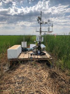
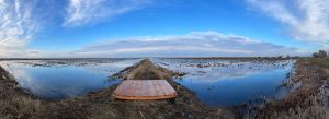
 US-RGB
 US-RGB Eddy Covariance Station
Keywords: SMARTFARM, ARPA-E, rice, nitrous oxide, methane,
Location: United States
View in Original Size
To download, right-click photo (Mac: control-click) and choose Save Image As
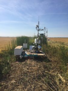
US-RGB Butte rice summer
Keywords: —
Location: California, United States
View in Original Size
To download, right-click photo (Mac: control-click) and choose Save Image As
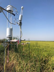 US-RGB
 EC butte
Keywords: —
Location: California, United States
View in Original Size
To download, right-click photo (Mac: control-click) and choose Save Image As
 US-RGB
 EC butte
Keywords: —
Location: California, United States
View in Original Size
To download, right-click photo (Mac: control-click) and choose Save Image As
 US-RGB
 Site Picture for US-RGB
Keywords: Rice, Ag., CO2, CH4, N2O
Location: United States
View in Original Size
To download, right-click photo (Mac: control-click) and choose Save Image As
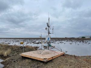
 US-RGB
 Site Picture for US-RGB (before setup)
Keywords: Rice, Ag., CO2, CH4, N2O
Location: California, United States
View in Original Size
To download, right-click photo (Mac: control-click) and choose Save Image As
US-RGB: Butte County Rice Farm
- Overview
- Windroses
- Data Citation
- Data Use Log
- Image Gallery
- Remote Sensing Data
- MODIS
- PhenoCam
- GeoNEX
- Publications
- BADM
MODIS NDVI
The time series shows the 16-day Normalized Difference Vegetation Index (NDVI) average from the MOD13Q1 data product.
Use the slider below the time series to zoom in and out.
To view / download these data and other MOD13Q1 products for this site, visit MODIS/Terra Vegetation Indices.
For other related products, visit MODIS/VIIRS Fixed Sites Subsets Tool.
Citation:
ORNL DAAC. 2018. Terrestrial Ecology Subsetting & Visualization Services (TESViS) Fixed Sites Subsets. ORNL DAAC, Oak Ridge, Tennessee, USA. https://doi.org/10.3334/ORNLDAAC/1567
MODIS NDVI subsetted data is not yet available for this site.
For a complete list of AmeriFlux sites, visit ORNL DAAC's MODIS/VIIRS Fixed Sites Subsets Tool.


US-RGB: Butte County Rice Farm
- Overview
- Windroses
- Data Citation
- Data Use Log
- Image Gallery
- Remote Sensing Data
- MODIS
- PhenoCam
- GeoNEX
- Publications
- BADM
| AmeriFlux Publications | Add Publication |
US-RGB: Butte County Rice Farm
- Overview
- Windroses
- Data Citation
- Data Use Log
- Image Gallery
- Remote Sensing Data
- MODIS
- PhenoCam
- GeoNEX
- Publications
- BADM
BADM for This Site
Access the Biological, Ancillary, Disturbance and Metadata (BADM) information and data for this site.
BADM contain information for many uses, such as characterizing a site’s vegetation and soil, describing disturbance history, and defining instrumentation for flux processing. They complement the flux/met data.
- Download BADM for this site*
- View Site General Info for this site (Overview tab)*
- Use Online Editor to update Site General Info or DOI Authorship
- Update information about submitted data (Variable Information tool)
- More BADM resources
* Online updates are shown on the Overview tab real time. However, downloaded BADM files will not reflect those updates until they have been reviewed for QA/QC.
US-RGB: Butte County Rice Farm
- Overview
- Windroses
- Data Citation
- Data Use Log
- Image Gallery
- Remote Sensing Data
- MODIS
- PhenoCam
- GeoNEX
- Publications
- BADM