
US-RC1: Cook Agronomy Farm - No Till
- Overview
- Windroses
- Data Citation
- Data Use Log
- Image Gallery
- Remote Sensing Data
- MODIS
- PhenoCam
- GeoNEX
- Publications
- BADM
| Tower_team: | |
| PI: | Brian Lamb blamb@wsu.edu - Washington State University |
| PI: | Jinshu Chi jinshuchi@hkust-gz.edu.cn - The Hong Kong University of Science and Technology, Guangzhou |
| PI: | Shelley Pressley spressley@wsu.edu - Washington State University |
| AncContact: | Bryan Carlson bryan.carlson@usda.gov - USDA-ARS NSARU |
| DataManager: | Eric Russell eric.s.russell@wsu.edu - Washington State University |
| Lat, Long: | 46.7837, -117.0777 |
| Elevation(m): | 807 |
| Network Affiliations: | AmeriFlux, LTAR |
| Vegetation IGBP: | CRO (Croplands: Lands covered with temporary crops followed by harvest and a bare soil period (e.g., single and multiple cropping systems). Note that perennial woody crops will be classified as the appropriate forest or shrub land cover type.) |
| Climate Koeppen: | Dsb (Warm Summer Continental: warm summer) |
| Mean Annual Temp (°C): | 9 |
| Mean Annual Precip. (mm): | 550 |
| Flux Species Measured: | CO2, H2O |
| Years Data Collected: | 2011 - 2016 |
| Years Data Available: | AmeriFlux BASE 2011 - 2016 Data Citation |
| Data Use Policy: | AmeriFlux CC-BY-4.0 Policy1 |
| Description: | |
| URL: | https://www.reacchpna.org/ |
| Research Topics: | — |
| Acknowledgment: | The Regional Approaches to Climate Change project was funded by award #2011-68002-30191 from the National Institute of Food and Agriculture. |
- This site’s data can also be used under the more restrictive AmeriFlux Legacy Policy.
The AmeriFlux Legacy Policy must be followed if this site’s data are combined with data from sites that require the AmeriFlux Legacy Policy.
Copyright preference: As long as credit is given
US-RC1: Cook Agronomy Farm - No Till
- Overview
- Windroses
- Data Citation
- Data Use Log
- Image Gallery
- Remote Sensing Data
- MODIS
- PhenoCam
- GeoNEX
- Publications
- BADM
Use the information below for citation of this site. See the Data Policy page for more details.
DOI(s) for citing US-RC1 data
Data Use Policy: AmeriFlux CC-BY-4.0 License
This site’s data can also be used under the more restrictive AmeriFlux Legacy Policy.
The AmeriFlux Legacy Policy must be followed if US-RC1 data are combined with data from sites that require the AmeriFlux Legacy Policy.
- AmeriFlux BASE: https://doi.org/10.17190/AMF/1498748
Citation: Jinshu Chi, Brian Lamb, Shelley Pressley (2021), AmeriFlux BASE US-RC1 Cook Agronomy Farm - No Till, Ver. 2-5, AmeriFlux AMP, (Dataset). https://doi.org/10.17190/AMF/1498748
To cite BADM when downloaded on their own, use the publications below for citing site characterization. When using BADM that are downloaded with AmeriFlux BASE and AmeriFlux FLUXNET products, use the DOI citation for the associated data product.
Publication(s) for citing site characterization
- —
Acknowledgments
- —
Resources
- AmeriFlux Logos & Acknowledgments
US-RC1: Cook Agronomy Farm - No Till
- Overview
- Windroses
- Data Citation
- Data Use Log
- Image Gallery
- Remote Sensing Data
- MODIS
- PhenoCam
- GeoNEX
- Publications
- BADM

This page displays the list of downloads of data for the site {{siteId}}.
Note: Results are the number of downloads to distinct data users. The Download Count column indicates the number of times the data user downloaded the data. The Version column refers to the version of the data product for the site that was downloaded by the data user.
| Date | Name | Data Product | Vers. | Intended Use | Intended Use Description | Download Count |
|---|---|---|---|---|---|---|
| {{dlObject.timeStamp}} | {{dlObject.displayName}} | {{displayProduct(dlObject.dataProduct)}} | {{dlObject.version}} | {{dlObject.intendedUse}} | {{dlObject.comment}} | {{dlObject.downloadCounter}} |
Showing {{startItem + 1}} to {{(startItem + items) > filtered.length ? filtered.length : (startItem + items)}} of {{filtered.length}} results
Showing 0 to 0 of 0 results
Not Found
Uh Oh. Something is missing. Try double checking the URL and try again.
US-RC1: Cook Agronomy Farm - No Till
- Overview
- Windroses
- Data Citation
- Data Use Log
- Image Gallery
- Remote Sensing Data
- MODIS
- PhenoCam
- GeoNEX
- Publications
- BADM
| AmeriFlux Images | Add Image |
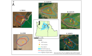
US-RC1 EC Sites within the REACCH set.
Locations of sites associated with the Regional Approaches to Climate Change (REACCH) USDA-supported research program (US-RC1 = CAF-NT; US-RC2 = CAF-CT; US-RC3 = LIND; US-RC4 = MMTN; US-RC5 = MSLK). Figure 1 from Chi et al. 2017 (doi: 10.1002/2017JG004148).
Keywords: dryland, wheat PNW
Location: Washington, United States
View in Original Size
To download, right-click photo (Mac: control-click) and choose Save Image As
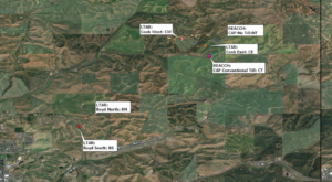 US-RC1
 EC towers associated with the CAF LTAR
Locations of sites associated with the CAF-LTAR site near Pullman, Washington. US-RC1 is CAF-No till, US-RCS2 is CAF Conventional Till, US-CF1 is Cook East, US-CF2 is Cook West, US-CF3 is Boyd North, and US-CF4 is Boyd South.
Keywords: LTAR, wheat, dryland
Location: Washington, United States
View in Original Size
To download, right-click photo (Mac: control-click) and choose Save Image As
US-RC1: Cook Agronomy Farm - No Till
- Overview
- Windroses
- Data Citation
- Data Use Log
- Image Gallery
- Remote Sensing Data
- MODIS
- PhenoCam
- GeoNEX
- Publications
- BADM
| AmeriFlux Publications | Add Publication |
| Year | Publication |
|---|---|
| 2021 | Chu, H., Luo, X., Ouyang, Z., Chan, W. S., Dengel, S., Biraud, S. C., Torn, M. S., Metzger, S., Kumar, J., Arain, M. A., Arkebauer, T. J., Baldocchi, D., Bernacchi, C., Billesbach, D., Black, T. A., Blanken, P. D., Bohrer, G., Bracho, R., Brown, S., Brunsell, N. A., Chen, J., Chen, X., Clark, K., Desai, A. R., Duman, T., Durden, D., Fares, S., Forbrich, I., Gamon, J. A., Gough, C. M., Griffis, T., Helbig, M., Hollinger, D., Humphreys, E., Ikawa, H., Iwata, H., Ju, Y., Knowles, J. F., Knox, S. H., Kobayashi, H., Kolb, T., Law, B., Lee, X., Litvak, M., Liu, H., Munger, J. W., Noormets, A., Novick, K., Oberbauer, S. F., Oechel, W., Oikawa, P., Papuga, S. A., Pendall, E., Prajapati, P., Prueger, J., Quinton, W. L., Richardson, A. D., Russell, E. S., Scott, R. L., Starr, G., Staebler, R., Stoy, P. C., Stuart-Haëntjens, E., Sonnentag, O., Sullivan, R. C., Suyker, A., Ueyama, M., Vargas, R., Wood, J. D., Zona, D. (2021) Representativeness Of Eddy-Covariance Flux Footprints For Areas Surrounding Ameriflux Sites, Agricultural And Forest Meteorology, 301-302, 108350. https://doi.org/10.1016/j.agrformet.2021.108350 |
| 2019 | Waldo, S., Russell, E. S., Kostyanovsky, K., Pressley, S. N., O'Keeffe, P. T., Huggins, D. R., Stöckle, C. O., Pan, W. L., Lamb, B. K. (2019) N2O Emissions From Two Agroecosystems: High Spatial Variability And Long Pulses Observed Using Static Chambers And The Flux‐Gradient Technique, Journal Of Geophysical Research: Biogeosciences, 124(7), 1887-1904. https://doi.org/https://doi.org/10.1029/2019JG005032 |
| 2017 | Chi, J., Waldo, S., Pressley, S. N., Russell, E. S., O'Keeffe, P. T., Pan, W. L., Huggins, D. R., Stöckle, C. O., Brooks, E. S., Lamb, B. K. (2017) Effects Of Climatic Conditions And Management Practices On Agricultural Carbon And Water Budgets In The Inland Pacific Northwest Usa, Journal Of Geophysical Research: Biogeosciences, 122(12), 3142-3160. https://doi.org/10.1002/2017JG004148 |
| 2017 | Chi, J., Maureira, F., Waldo, S., Pressley, S. N., Stöckle, C. O., O'Keeffe, P. T., Pan, W. L., Brooks, E. S., Huggins, D. R., Lamb, B. K. (2017) Carbon And Water Budgets In Multiple Wheat-Based Cropping Systems In The Inland Pacific Northwest Us: Comparison Of Cropsyst Simulations With Eddy Covariance Measurements, Frontiers In Ecology And Evolution, 5, . https://doi.org/10.3389/fevo.2017.00050 |
| 2016 | Waldo, S., Chi, J., Pressley, S. N., O’Keeffe, P., Pan, W. L., Brooks, E. S., Huggins, D. R., Stöckle, C. O., Lamb, B. K. (2016) Assessing Carbon Dynamics At High And Low Rainfall Agricultural Sites In The Inland Pacific Northwest Us Using The Eddy Covariance Method, Agricultural And Forest Meteorology, 218-219, 25-36. https://doi.org/10.1016/j.agrformet.2015.11.018 |
| 2016 | Chi, J., Waldo, S., Pressley, S., O’Keeffe, P., Huggins, D., Stöckle, C., Pan, W. L., Brooks, E., Lamb, B. (2016) Assessing Carbon And Water Dynamics Of No-Till And Conventional Tillage Cropping Systems In The Inland Pacific Northwest Us Using The Eddy Covariance Method, Agricultural And Forest Meteorology, 218-219, 37-49. https://doi.org/10.1016/j.agrformet.2015.11.019 |
US-RC1: Cook Agronomy Farm - No Till
- Overview
- Windroses
- Data Citation
- Data Use Log
- Image Gallery
- Remote Sensing Data
- MODIS
- PhenoCam
- GeoNEX
- Publications
- BADM
BADM for This Site
Access the Biological, Ancillary, Disturbance and Metadata (BADM) information and data for this site.
BADM contain information for many uses, such as characterizing a site’s vegetation and soil, describing disturbance history, and defining instrumentation for flux processing. They complement the flux/met data.
- Download BADM for this site*
- View Site General Info for this site (Overview tab)*
- Use Online Editor to update Site General Info or DOI Authorship
- Update information about submitted data (Variable Information tool)
- More BADM resources
* Online updates are shown on the Overview tab real time. However, downloaded BADM files will not reflect those updates until they have been reviewed for QA/QC.
US-RC1: Cook Agronomy Farm - No Till
- Overview
- Windroses
- Data Citation
- Data Use Log
- Image Gallery
- Remote Sensing Data
- MODIS
- PhenoCam
- GeoNEX
- Publications
- BADM
Wind Roses
Wind Speed (m/s)
- Wind Speed Scale: Per Site
- Wind Direction Scale (%): Per Site
- Wind Speed Scale: Non-Linear
- Wind Direction Scale (%): AmeriFlux