
US-PFo: SE1 Lake-2 CHEESEHEAD 2019
- Overview
- Windroses
- Data Citation
- Data Use Log
- Image Gallery
- Remote Sensing Data
- MODIS
- PhenoCam
- GeoNEX
- Publications
- BADM
| Tower_team: | |
| PI: | Ankur Desai desai@aos.wisc.edu - University of Wisconsin-Madison |
| FluxContact: | Brian Butterworth bbutterworth@wisc.edu - University of Wisconsin-Madison |
| FluxContact: | Jonathan Thom jthom@ssec.wisc.edu - University of Wisconsin-Madison |
| FluxContact: | Paul Stoy paul.stoy@montana.edu - Montana State University |
| Lat, Long: | 45.9229, -90.2728 |
| Elevation(m): | 476 |
| Network Affiliations: | AmeriFlux |
| Vegetation IGBP: | WAT (Water Bodies : Oceans, seas, lakes, reservoirs, and rivers. Can be either fresh or salt- water bodies.) |
| Climate Koeppen: | Dfb (Warm Summer Continental: significant precipitation in all seasons ) |
| Mean Annual Temp (°C): | 4.33 |
| Mean Annual Precip. (mm): | 823 |
| Flux Species Measured: | CO2, H, H2O |
| Years Data Collected: | 2019 - 2019 |
| Years Data Available: | AmeriFlux BASE 2019 Data Citation |
| Data Use Policy: | AmeriFlux CC-BY-4.0 Policy1 |
| Description: | |
| URL: | https://www.eol.ucar.edu/field_projects/cheesehead |
| Research Topics: | |
| Acknowledgment: | Supported by National Science Foundation (NSF) Award #1822420 |
- This site’s data can also be used under the more restrictive AmeriFlux Legacy Policy.
The AmeriFlux Legacy Policy must be followed if this site’s data are combined with data from sites that require the AmeriFlux Legacy Policy.
Copyright preference: Open use
US-PFo: SE1 Lake-2 CHEESEHEAD 2019
- Overview
- Windroses
- Data Citation
- Data Use Log
- Image Gallery
- Remote Sensing Data
- MODIS
- PhenoCam
- GeoNEX
- Publications
- BADM
Use the information below for citation of this site. See the Data Policy page for more details.
DOI(s) for citing US-PFo data
Data Use Policy: AmeriFlux CC-BY-4.0 License
This site’s data can also be used under the more restrictive AmeriFlux Legacy Policy.
The AmeriFlux Legacy Policy must be followed if US-PFo data are combined with data from sites that require the AmeriFlux Legacy Policy.
- AmeriFlux BASE: https://doi.org/10.17190/AMF/1880912
Citation: Ankur Desai, Brian Butterworth, Jonathan Thom, Paul Stoy (2022), AmeriFlux BASE US-PFo SE1 Lake-2 CHEESEHEAD 2019, Ver. 1-5, AmeriFlux AMP, (Dataset). https://doi.org/10.17190/AMF/1880912
To cite BADM when downloaded on their own, use the publications below for citing site characterization. When using BADM that are downloaded with AmeriFlux BASE and AmeriFlux FLUXNET products, use the DOI citation for the associated data product.
Publication(s) for citing site characterization
- —
Acknowledgments
- —
Resources
- AmeriFlux Logos & Acknowledgments
US-PFo: SE1 Lake-2 CHEESEHEAD 2019
- Overview
- Windroses
- Data Citation
- Data Use Log
- Image Gallery
- Remote Sensing Data
- MODIS
- PhenoCam
- GeoNEX
- Publications
- BADM

This page displays the list of downloads of data for the site {{siteId}}.
Note: Results are the number of downloads to distinct data users. The Download Count column indicates the number of times the data user downloaded the data. The Version column refers to the version of the data product for the site that was downloaded by the data user.
| Date | Name | Data Product | Vers. | Intended Use | Intended Use Description | Download Count |
|---|---|---|---|---|---|---|
| {{dlObject.timeStamp}} | {{dlObject.displayName}} | {{displayProduct(dlObject.dataProduct)}} | {{dlObject.version}} | {{dlObject.intendedUse}} | {{dlObject.comment}} | {{dlObject.downloadCounter}} |
Showing {{startItem + 1}} to {{(startItem + items) > filtered.length ? filtered.length : (startItem + items)}} of {{filtered.length}} results
Showing 0 to 0 of 0 results
Not Found
Uh Oh. Something is missing. Try double checking the URL and try again.
US-PFo: SE1 Lake-2 CHEESEHEAD 2019
- Overview
- Windroses
- Data Citation
- Data Use Log
- Image Gallery
- Remote Sensing Data
- MODIS
- PhenoCam
- GeoNEX
- Publications
- BADM
| AmeriFlux Images | Add Image |
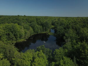
US-PFo PFo SE1 deadpool lake from above
Keywords: —
Location:
View in Original Size
To download, right-click photo (Mac: control-click) and choose Save Image As
US-PFo: SE1 Lake-2 CHEESEHEAD 2019
- Overview
- Windroses
- Data Citation
- Data Use Log
- Image Gallery
- Remote Sensing Data
- MODIS
- PhenoCam
- GeoNEX
- Publications
- BADM
| AmeriFlux Publications | Add Publication |
US-PFo: SE1 Lake-2 CHEESEHEAD 2019
- Overview
- Windroses
- Data Citation
- Data Use Log
- Image Gallery
- Remote Sensing Data
- MODIS
- PhenoCam
- GeoNEX
- Publications
- BADM
BADM for This Site
Access the Biological, Ancillary, Disturbance and Metadata (BADM) information and data for this site.
BADM contain information for many uses, such as characterizing a site’s vegetation and soil, describing disturbance history, and defining instrumentation for flux processing. They complement the flux/met data.
- Download BADM for this site*
- View Site General Info for this site (Overview tab)*
- Use Online Editor to update Site General Info or DOI Authorship
- Update information about submitted data (Variable Information tool)
- More BADM resources
* Online updates are shown on the Overview tab real time. However, downloaded BADM files will not reflect those updates until they have been reviewed for QA/QC.
US-PFo: SE1 Lake-2 CHEESEHEAD 2019
- Overview
- Windroses
- Data Citation
- Data Use Log
- Image Gallery
- Remote Sensing Data
- MODIS
- PhenoCam
- GeoNEX
- Publications
- BADM