
US-ORv: Olentangy River Wetland Research Park
- Overview
- Windroses
- Data Citation
- Data Use Log
- Image Gallery
- Remote Sensing Data
- MODIS
- PhenoCam
- GeoNEX
- Publications
- BADM
| Tower_team: | |
| PI: | Gil Bohrer bohrer.17@osu.edu - The Ohio State University |
| DataManager: | Justine Missik missik.2@osu.edu - Ohio State University |
| Lat, Long: | 40.0201, -83.0183 |
| Elevation(m): | 221 |
| Network Affiliations: | AmeriFlux |
| Vegetation IGBP: | WET (Permanent Wetlands: Lands with a permanent mixture of water and herbaceous or woody vegetation that cover extensive areas. The vegetation can be present in either salt, brackish, or fresh water) |
| Climate Koeppen: | Cfa (Humid Subtropical: mild with no dry season, hot summer) |
| Mean Annual Temp (°C): | 11.63 |
| Mean Annual Precip. (mm): | 1499.1 |
| Flux Species Measured: | CO2, CH4 |
| Years Data Collected: | 2011 - 2016 |
| Years Data Available: | AmeriFlux BASE 2011 - 2016 Data Citation AmeriFlux FLUXNET 2011 - 2016 Data Citation |
| Data Use Policy: | AmeriFlux CC-BY-4.0 Policy1 |
| Description: | |
| URL: | http://flux.org.ohio-state.edu/ |
| Research Topics: | |
| Acknowledgment: | — |
- This site’s data can also be used under the more restrictive AmeriFlux Legacy Policy.
The AmeriFlux Legacy Policy must be followed if this site’s data are combined with data from sites that require the AmeriFlux Legacy Policy.
Copyright preference: Request for permission
US-ORv: Olentangy River Wetland Research Park
- Overview
- Windroses
- Data Citation
- Data Use Log
- Image Gallery
- Remote Sensing Data
- MODIS
- PhenoCam
- GeoNEX
- Publications
- BADM
Use the information below for citation of this site. See the Data Policy page for more details.
DOI(s) for citing US-ORv data
Data Use Policy: AmeriFlux CC-BY-4.0 License
This site’s data can also be used under the more restrictive AmeriFlux Legacy Policy.
The AmeriFlux Legacy Policy must be followed if US-ORv data are combined with data from sites that require the AmeriFlux Legacy Policy.
- AmeriFlux BASE: https://doi.org/10.17190/AMF/1246135
Citation: Gil Bohrer (2025), AmeriFlux BASE US-ORv Olentangy River Wetland Research Park, Ver. 4-5, AmeriFlux AMP, (Dataset). https://doi.org/10.17190/AMF/1246135 - AmeriFlux FLUXNET: https://doi.org/10.17190/AMF/1832164
Citation: Gil Bohrer (2025), AmeriFlux FLUXNET-1F US-ORv Olentangy River Wetland Research Park, Ver. 5-7, AmeriFlux AMP, (Dataset). https://doi.org/10.17190/AMF/1832164
Find global FLUXNET datasets, like FLUXNET2015 and FLUXNET-CH4, and their citation information at fluxnet.org.
To cite BADM when downloaded on their own, use the publications below for citing site characterization. When using BADM that are downloaded with AmeriFlux BASE and AmeriFlux FLUXNET products, use the DOI citation for the associated data product.
Publication(s) for citing site characterization
- —
Acknowledgments
- —
Resources
- AmeriFlux Logos & Acknowledgments
US-ORv: Olentangy River Wetland Research Park
- Overview
- Windroses
- Data Citation
- Data Use Log
- Image Gallery
- Remote Sensing Data
- MODIS
- PhenoCam
- GeoNEX
- Publications
- BADM

This page displays the list of downloads of data for the site {{siteId}}.
Note: Results are the number of downloads to distinct data users. The Download Count column indicates the number of times the data user downloaded the data. The Version column refers to the version of the data product for the site that was downloaded by the data user.
| Date | Name | Data Product | Vers. | Intended Use | Intended Use Description | Download Count |
|---|---|---|---|---|---|---|
| {{dlObject.timeStamp}} | {{dlObject.displayName}} | {{displayProduct(dlObject.dataProduct)}} | {{dlObject.version}} | {{dlObject.intendedUse}} | {{dlObject.comment}} | {{dlObject.downloadCounter}} |
Showing {{startItem + 1}} to {{(startItem + items) > filtered.length ? filtered.length : (startItem + items)}} of {{filtered.length}} results
Showing 0 to 0 of 0 results
Not Found
Uh Oh. Something is missing. Try double checking the URL and try again.
US-ORv: Olentangy River Wetland Research Park
- Overview
- Windroses
- Data Citation
- Data Use Log
- Image Gallery
- Remote Sensing Data
- MODIS
- PhenoCam
- GeoNEX
- Publications
- BADM
| AmeriFlux Images | Add Image |
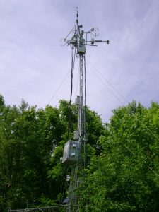
US-ORv 2011.OlentangiRiver.sitevisit.DSC00041
2011.OlentangiRiver.sitevisit.DSC00041
Keywords: —
Location:
View in Original Size
To download, right-click photo (Mac: control-click) and choose Save Image As
US-ORv: Olentangy River Wetland Research Park
- Overview
- Windroses
- Data Citation
- Data Use Log
- Image Gallery
- Remote Sensing Data
- MODIS
- PhenoCam
- GeoNEX
- Publications
- BADM
| AmeriFlux Publications | Add Publication |
| Year | Publication |
|---|---|
| 2021 | Chu, H., Luo, X., Ouyang, Z., Chan, W. S., Dengel, S., Biraud, S. C., Torn, M. S., Metzger, S., Kumar, J., Arain, M. A., Arkebauer, T. J., Baldocchi, D., Bernacchi, C., Billesbach, D., Black, T. A., Blanken, P. D., Bohrer, G., Bracho, R., Brown, S., Brunsell, N. A., Chen, J., Chen, X., Clark, K., Desai, A. R., Duman, T., Durden, D., Fares, S., Forbrich, I., Gamon, J. A., Gough, C. M., Griffis, T., Helbig, M., Hollinger, D., Humphreys, E., Ikawa, H., Iwata, H., Ju, Y., Knowles, J. F., Knox, S. H., Kobayashi, H., Kolb, T., Law, B., Lee, X., Litvak, M., Liu, H., Munger, J. W., Noormets, A., Novick, K., Oberbauer, S. F., Oechel, W., Oikawa, P., Papuga, S. A., Pendall, E., Prajapati, P., Prueger, J., Quinton, W. L., Richardson, A. D., Russell, E. S., Scott, R. L., Starr, G., Staebler, R., Stoy, P. C., Stuart-Haëntjens, E., Sonnentag, O., Sullivan, R. C., Suyker, A., Ueyama, M., Vargas, R., Wood, J. D., Zona, D. (2021) Representativeness Of Eddy-Covariance Flux Footprints For Areas Surrounding Ameriflux Sites, Agricultural And Forest Meteorology, 301-302, 108350. https://doi.org/10.1016/j.agrformet.2021.108350 |
| 2014 | Brooker, M. R., Bohrer, G., Mouser, P. J. (2014) Variations In Potential Ch4 Flux And Co2 Respiration From Freshwater Wetland Sediments That Differ By Microsite Location, Depth And Temperature, Ecological Engineering, 72, 84-94. https://doi.org/10.1016/j.ecoleng.2014.05.028 |
| 2019 | Sullivan, R. C., Kotamarthi, V. R., Feng, Y. (2019) Recovering Evapotranspiration Trends From Biased CMIP5 Simulations And Sensitivity To Changing Climate Over North America, Journal Of Hydrometeorology, 20(8), 1619-1633. https://doi.org/10.1175/JHM-D-18-0259.1 |
| 2019 | Sullivan, R. C., Cook, D. R., Ghate, V. P., Kotamarthi, V. R., Feng, Y. (2019) Improved Spatiotemporal Representativeness And Bias Reduction Of Satellite-Based Evapotranspiration Retrievals Via Use Of In Situ Meteorology And Constrained Canopy Surface Resistance, Journal Of Geophysical Research: Biogeosciences, 124(2), 342-352. https://doi.org/10.1029/2018JG004744 |
| 2017 | Morin, T.H., Bohrer, G., Stefanik, K.C., Rey-Sanchez, A.C., Matheny, A.M., Mitsch, W.J. (2017) Combining eddy-covariance and chamber measurements to determine the methane budget from a small, heterogeneous urban floodplain wetland park, Agricultural and Forest Meteorology, . |
| 2012 | Mitsch, W. J., Zhang, L., Stefanik, K. C., Nahlik, A. M., Anderson, C. J., Bernal, B., Hernandez, M., Song, K. (2012) Creating Wetlands: Primary Succession, Water Quality Changes, And Self-Design Over 15 Years, Bioscience, 62(3), 237-250. https://doi.org/10.1525/bio.2012.62.3.5 |
| 2014 | Morin, T.H. Bohrer, G. Naor-Azrieli, L. Mesi, S. Kenny, W.T. Mitsch, W.J. Schäfer, K.V.R. (2014) The seasonal and diurnal dynamics of methane flux at a created urban wetland, Ecological Engineering, 72, 74-83. https://doi.org/10.1016/j.ecoleng.2014.02.002 |
| 2014 | Morin, T.H. Bohrer, G. Frasson, R.P.dM. Naor-Azrieli, L. Mesi, S. Stefanik, K.C. Schäfer, K.V.R. (2014) Environmental drivers of methane fluxes from an urban temperate wetland park, Journal of Geophysical Research-Biogeosciences, 119, 2188-2208. https://doi.org/10.1002/2014JG002750 |
US-ORv: Olentangy River Wetland Research Park
- Overview
- Windroses
- Data Citation
- Data Use Log
- Image Gallery
- Remote Sensing Data
- MODIS
- PhenoCam
- GeoNEX
- Publications
- BADM
BADM for This Site
Access the Biological, Ancillary, Disturbance and Metadata (BADM) information and data for this site.
BADM contain information for many uses, such as characterizing a site’s vegetation and soil, describing disturbance history, and defining instrumentation for flux processing. They complement the flux/met data.
- Download BADM for this site*
- View Site General Info for this site (Overview tab)*
- Use Online Editor to update Site General Info or DOI Authorship
- Update information about submitted data (Variable Information tool)
- More BADM resources
* Online updates are shown on the Overview tab real time. However, downloaded BADM files will not reflect those updates until they have been reviewed for QA/QC.
US-ORv: Olentangy River Wetland Research Park
- Overview
- Windroses
- Data Citation
- Data Use Log
- Image Gallery
- Remote Sensing Data
- MODIS
- PhenoCam
- GeoNEX
- Publications
- BADM
Wind Roses
Wind Speed (m/s)
- Wind Speed Scale: Per Site
- Wind Direction Scale (%): Per Site
- Wind Speed Scale: Non-Linear
- Wind Direction Scale (%): AmeriFlux