
US-Nrs: Nisqually restoring
- Overview
- Windroses
- Data Citation
- Data Use Log
- Image Gallery
- Remote Sensing Data
- MODIS
- PhenoCam
- GeoNEX
- Publications
- BADM
| Tower_team: | |
| PI: | Brian Bergamaschi bbergama@usgs.gov - USGS |
| PI: | Lisamarie Windham-Myers lwindham-myers@usgs.gov - USGS |
| AncContact: | Ellen Stuart-Haëntjens egoodrich-stuart@usgs.gov - USGS |
| AncContact: | Sara Knox sara.knox@ubc.ca - UBC Geography |
| Lat, Long: | 47.0936, -122.7079 |
| Elevation(m): | 8 |
| Network Affiliations: | AmeriFlux |
| Vegetation IGBP: | WET (Permanent Wetlands: Lands with a permanent mixture of water and herbaceous or woody vegetation that cover extensive areas. The vegetation can be present in either salt, brackish, or fresh water) |
| Climate Koeppen: | Csb (Mediterranean: mild with dry, warm summer) |
| Mean Annual Temp (°C): | 10.3 |
| Mean Annual Precip. (mm): | 1269 |
| Flux Species Measured: | CO2, CH4, H, H2O |
| Years Data Collected: | 2017 - Present |
| Years Data Available: | No data available |
| Data Use Policy: | AmeriFlux CC-BY-4.0 Policy1 |
| Description: | |
| URL: | https://www.werc.usgs.gov/ProjectSubWebPage.aspx?SubWebPageID=10&ProjectID=279 |
| Research Topics: | |
| Acknowledgment: | USGS Land Carbon Program and United States Fish and Wildlife Service |
- This site’s data can also be used under the more restrictive AmeriFlux Legacy Policy.
The AmeriFlux Legacy Policy must be followed if this site’s data are combined with data from sites that require the AmeriFlux Legacy Policy.
Copyright preference: As long as credit is given
US-Nrs: Nisqually restoring
- Overview
- Windroses
- Data Citation
- Data Use Log
- Image Gallery
- Remote Sensing Data
- MODIS
- PhenoCam
- GeoNEX
- Publications
- BADM
Use the information below for citation of this site. See the Data Policy page for more details.
DOI(s) for citing US-Nrs data
Data Use Policy: AmeriFlux CC-BY-4.0 License
- No DOIs available for US-Nrs
To cite BADM downloaded as a BIF file, use the publications listed below.
Publication(s) for citing site characterization
- —
Acknowledgments
- —
Resources
- AmeriFlux Logos & Acknowledgments
US-Nrs: Nisqually restoring
- Overview
- Windroses
- Data Citation
- Data Use Log
- Image Gallery
- Remote Sensing Data
- MODIS
- PhenoCam
- GeoNEX
- Publications
- BADM

This page displays the list of downloads of data for the site {{siteId}}.
Note: Results are the number of downloads to distinct data users. The Download Count column indicates the number of times the data user downloaded the data. The Version column refers to the version of the data product for the site that was downloaded by the data user.
| Date | Name | Data Product | Vers. | Intended Use | Intended Use Description | Download Count |
|---|---|---|---|---|---|---|
| {{dlObject.timeStamp}} | {{dlObject.displayName}} | {{displayProduct(dlObject.dataProduct)}} | {{dlObject.version}} | {{dlObject.intendedUse}} | {{dlObject.comment}} | {{dlObject.downloadCounter}} |
Showing {{startItem + 1}} to {{(startItem + items) > filtered.length ? filtered.length : (startItem + items)}} of {{filtered.length}} results
Showing 0 to 0 of 0 results
Not Found
Uh Oh. Something is missing. Try double checking the URL and try again.
US-Nrs: Nisqually restoring
- Overview
- Windroses
- Data Citation
- Data Use Log
- Image Gallery
- Remote Sensing Data
- MODIS
- PhenoCam
- GeoNEX
- Publications
- BADM
| AmeriFlux Images | Add Image |
 US-Nrs
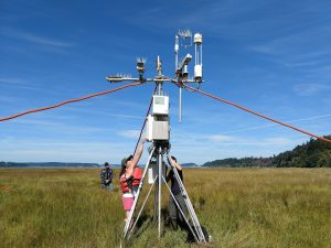
 US-Nrf Tower
Eddy co-variance flux tower at the reference wetland at the Billy Frank Jr. Nisqually National Wildlife Refuge.
Keywords: eddy flux, flux tower, AmeriFlux, Nisqually, methane, carbon dioxide, wetland, marsh, Nrf, US-Nrf, salt marsh, LI-7700, LI-7500
Location: Washington, United States
View in Original Size
To download, right-click photo (Mac: control-click) and choose Save Image As
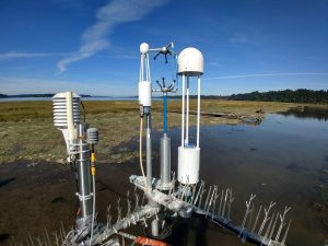
US-Nrs US-Nrs
Eddy co-variance flux tower at the restoring wetland at the Billy Frank Jr. Nisqually National Wildlife Refuge.
Keywords: eddy flux, flux tower, Nisqually, methane, carbon dioxide, wetland, marsh, Nrs, US-Nrs, salt marsh, restoring, restoration, LI-7700, LI-7500
Location: California, United States
View in Original Size
To download, right-click photo (Mac: control-click) and choose Save Image As
US-Nrs: Nisqually restoring
- Overview
- Windroses
- Data Citation
- Data Use Log
- Image Gallery
- Remote Sensing Data
- MODIS
- PhenoCam
- GeoNEX
- Publications
- BADM
| AmeriFlux Publications | Add Publication |
US-Nrs: Nisqually restoring
- Overview
- Windroses
- Data Citation
- Data Use Log
- Image Gallery
- Remote Sensing Data
- MODIS
- PhenoCam
- GeoNEX
- Publications
- BADM
BADM for This Site
Access the Biological, Ancillary, Disturbance and Metadata (BADM) information and data for this site.
BADM contain information for many uses, such as characterizing a site’s vegetation and soil, describing disturbance history, and defining instrumentation for flux processing. They complement the flux/met data.
- Download BADM for this site*
- View Site General Info for this site (Overview tab)*
- Use Online Editor to update Site General Info or DOI Authorship
- Update information about submitted data (Variable Information tool)
- More BADM resources
* Online updates are shown on the Overview tab real time. However, downloaded BADM files will not reflect those updates until they have been reviewed for QA/QC.
US-Nrs: Nisqually restoring
- Overview
- Windroses
- Data Citation
- Data Use Log
- Image Gallery
- Remote Sensing Data
- MODIS
- PhenoCam
- GeoNEX
- Publications
- BADM