
US-NR4: Niwot Ridge Alpine (T-Van East)
- Overview
- Windroses
- Data Citation
- Data Use Log
- Image Gallery
- Remote Sensing Data
- MODIS
- PhenoCam
- GeoNEX
- Publications
- BADM
| Tower_team: | |
| PI: | John Knowles John.knowles@montana.edu - Montana State University |
| AncContact: | Sarah Elmendorf Sarah.Elmendorf@Colorado.edu - University of Colorado Boulder |
| FluxContact: | Peter Blanken blanken@Colorado.edu - University of Colorado Boulder |
| Lat, Long: | 40.0520, -105.5859 |
| Elevation(m): | 3502 |
| Network Affiliations: | AmeriFlux |
| Vegetation IGBP: | GRA (Grasslands: Lands with herbaceous types of cover. Tree and shrub cover is less than 10%. Permanent wetlands lands with a permanent mixture of water and herbaceous or woody vegetation. The vegetation can be present in either salt, brackish, or fresh water.) |
| Climate Koeppen: | ET (Tundra) |
| Mean Annual Temp (°C): | -2.2 |
| Mean Annual Precip. (mm): | 884 |
| Flux Species Measured: | CO2, H2O |
| Years Data Collected: | 2007 - Present |
| Years Data Available: | AmeriFlux BASE 2007 - 2024 Data Citation |
| Data Use Policy: | AmeriFlux CC-BY-4.0 Policy1 |
| Description: | |
| URL: | https://nwt.lternet.edu/ |
| Research Topics: | Sublimation; Carbon cycle; Water balance; Ecosystem function in complex mountain terrain |
| Acknowledgment: | Funding was provided by National Science Foundation DEB awards 0423662, 1027341, 1637686, and 2224439 to the Niwot Ridge LTER. |
- This site’s data can also be used under the more restrictive AmeriFlux Legacy Policy.
The AmeriFlux Legacy Policy must be followed if this site’s data are combined with data from sites that require the AmeriFlux Legacy Policy.
Copyright preference: As long as credit is given
US-NR4: Niwot Ridge Alpine (T-Van East)
- Overview
- Windroses
- Data Citation
- Data Use Log
- Image Gallery
- Remote Sensing Data
- MODIS
- PhenoCam
- GeoNEX
- Publications
- BADM
Use the information below for citation of this site. See the Data Policy page for more details.
DOI(s) for citing US-NR4 data
Data Use Policy: AmeriFlux CC-BY-4.0 License
This site’s data can also be used under the more restrictive AmeriFlux Legacy Policy.
The AmeriFlux Legacy Policy must be followed if US-NR4 data are combined with data from sites that require the AmeriFlux Legacy Policy.
- AmeriFlux BASE: https://doi.org/10.17190/AMF/1804492
Citation: John Knowles (2025), AmeriFlux BASE US-NR4 Niwot Ridge Alpine (T-Van East), Ver. 6-5, AmeriFlux AMP, (Dataset). https://doi.org/10.17190/AMF/1804492
To cite BADM when downloaded on their own, use the publications below for citing site characterization. When using BADM that are downloaded with AmeriFlux BASE and AmeriFlux FLUXNET products, use the DOI citation for the associated data product.
Publication(s) for citing site characterization
- —
Acknowledgments
- —
Resources
- AmeriFlux Logos & Acknowledgments
US-NR4: Niwot Ridge Alpine (T-Van East)
- Overview
- Windroses
- Data Citation
- Data Use Log
- Image Gallery
- Remote Sensing Data
- MODIS
- PhenoCam
- GeoNEX
- Publications
- BADM

This page displays the list of downloads of data for the site {{siteId}}.
Note: Results are the number of downloads to distinct data users. The Download Count column indicates the number of times the data user downloaded the data. The Version column refers to the version of the data product for the site that was downloaded by the data user.
| Date | Name | Data Product | Vers. | Intended Use | Intended Use Description | Download Count |
|---|---|---|---|---|---|---|
| {{dlObject.timeStamp}} | {{dlObject.displayName}} | {{displayProduct(dlObject.dataProduct)}} | {{dlObject.version}} | {{dlObject.intendedUse}} | {{dlObject.comment}} | {{dlObject.downloadCounter}} |
Showing {{startItem + 1}} to {{(startItem + items) > filtered.length ? filtered.length : (startItem + items)}} of {{filtered.length}} results
Showing 0 to 0 of 0 results
Not Found
Uh Oh. Something is missing. Try double checking the URL and try again.
US-NR4: Niwot Ridge Alpine (T-Van East)
- Overview
- Windroses
- Data Citation
- Data Use Log
- Image Gallery
- Remote Sensing Data
- MODIS
- PhenoCam
- GeoNEX
- Publications
- BADM
| AmeriFlux Images | Add Image |
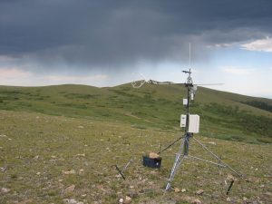
 US-NR4
 Mid-winter snow distribution results from the interaction of wind and micro-topography
Keywords: —
Location: Colorado, United States
View in Original Size
To download, right-click photo (Mac: control-click) and choose Save Image As
 US-NR4
 Snow accumulation after a wet spring storm
Keywords: —
Location: Colorado, United States
View in Original Size
To download, right-click photo (Mac: control-click) and choose Save Image As
 US-NR4
 Spring snow
Keywords: —
Location: Colorado, United States
View in Original Size
To download, right-click photo (Mac: control-click) and choose Save Image As
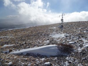
 US-NR4
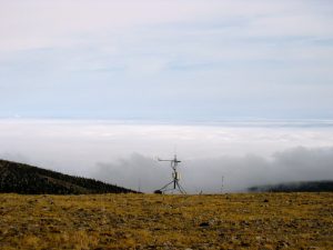
 Above the inversion
Keywords: —
Location: Colorado, United States
View in Original Size
To download, right-click photo (Mac: control-click) and choose Save Image As
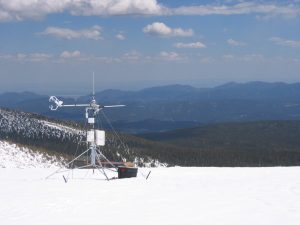
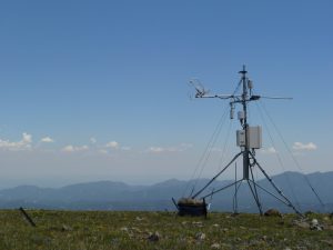 US-NR4
 Looking southeast
Keywords: —
Location: Colorado, United States
View in Original Size
To download, right-click photo (Mac: control-click) and choose Save Image As
 US-NR4
 Looking WSW toward Kiowa peak
Keywords: —
Location: Colorado, United States
View in Original Size
To download, right-click photo (Mac: control-click) and choose Save Image As
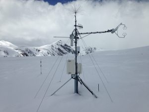
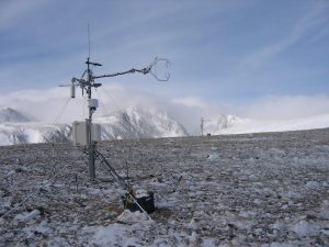
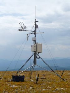 US-NR4
 Tower closeup
Keywords: —
Location: Colorado, United States
View in Original Size
To download, right-click photo (Mac: control-click) and choose Save Image As
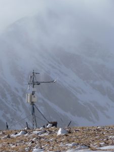
 US-NR4
 Typical snow-scoured winter conditions, US-NR3 in the background
Keywords: —
Location: Colorado, United States
View in Original Size
To download, right-click photo (Mac: control-click) and choose Save Image As
US-NR4 Looking east along Niwot Ridge
Keywords: —
Location: Colorado, United States
View in Original Size
To download, right-click photo (Mac: control-click) and choose Save Image As
US-NR4: Niwot Ridge Alpine (T-Van East)
- Overview
- Windroses
- Data Citation
- Data Use Log
- Image Gallery
- Remote Sensing Data
- MODIS
- PhenoCam
- GeoNEX
- Publications
- BADM
| AmeriFlux Publications | Add Publication |
| Year | Publication |
|---|---|
| 2023 | Jay, K. R., Wieder, W. R., Swenson, S. C., Knowles, J. F., Elmendorf, S. C., Holland‐Moritz, H., Suding, K. N. (2023) Topographic Heterogeneity And Aspect Moderate Exposure To Climate Change Across An Alpine Tundra Hillslope, Journal Of Geophysical Research: Biogeosciences, 128(11), . https://doi.org/10.1029/2023JG007664 |
| 2015 | Knowles, J. F., Harpold, A. A., Cowie, R., Zeliff, M., Barnard, H. R., Burns, S. P., Blanken, P. D., Morse, J. F., Williams, M. W. (2015) The Relative Contributions Of Alpine And Subalpine Ecosystems To The Water Balance Of A Mountainous, Headwater Catchment, Hydrological Processes, 29(22), 4794-4808. https://doi.org/10.1002/hyp.10526 |
| 2015 | Knowles, J. F., Blanken, P. D., Williams, M. W. (2015) Soil Respiration Variability Across A Soil Moisture And Vegetation Community Gradient Within A Snow-Scoured Alpine Meadow, Biogeochemistry, 125(2), 185-202. https://doi.org/10.1007/s10533-015-0122-3 |
| 2016 | Knowles, J. F., Blanken, P. D., Williams, M. W. (2016) Wet Meadow Ecosystems Contribute The Majority Of Overwinter Soil Respiration From Snow-Scoured Alpine Tundra, Journal Of Geophysical Research: Biogeosciences, 121(4), 1118-1130. https://doi.org/10.1002/2015JG003081 |
| 2017 | Wieder, W. R., Knowles, J. F., Blanken, P. D., Swenson, S. C., Suding, K. N. (2017) Ecosystem Function In Complex Mountain Terrain: Combining Models And Long-Term Observations To Advance Process-Based Understanding, Journal Of Geophysical Research: Biogeosciences, 122(4), 825-845. https://doi.org/10.1002/2016JG003704 |
| 2018 | Sexstone, G. A., Clow, D. W., Fassnacht, S. R., Liston, G. E., Hiemstra, C. A., Knowles, J. F., Penn, C. A. (2018) Snow Sublimation In Mountain Environments And Its Sensitivity To Forest Disturbance And Climate Warming, Water Resources Research, 54(2), 1191-1211. https://doi.org/10.1002/2017WR021172 |
| 2019 | Knowles, J. F., Blanken, P. D., Lawrence, C. R., Williams, M. W. (2019) Evidence For Non-Steady-State Carbon Emissions From Snow-Scoured Alpine Tundra, Nature Communications, 10(1), . https://doi.org/10.1038/s41467-019-09149-2 |
| 2012 | Knowles, J. F., Blanken, P. D., Williams, M. W., Chowanski, K. M. (2012) Energy And Surface Moisture Seasonally Limit Evaporation And Sublimation From Snow-Free Alpine Tundra, Agricultural And Forest Meteorology, 157, 106-115. https://doi.org/10.1016/j.agrformet.2012.01.017 |
| 2009 | Blanken, P. D., Williams, M. W., Burns, S. P., Monson, R. K., Knowles, J. F., Chowanski, K., Ackerman, T. (2009) A Comparison Of Water And Carbon Dioxide Exchange At A Windy Alpine Tundra And Subalpine Forest Site Near Niwot Ridge, Colorado, Biogeochemistry, 95(1), 61-76. https://doi.org/10.1007/s10533-009-9325-9 |
| 2015 | Knowles, J. F., Burns, S. P., Blanken, P. D., Monson, R. K. (2015) Fluxes Of Energy, Water, And Carbon Dioxide From Mountain Ecosystems At Niwot Ridge, Colorado, Plant Ecology & Diversity, 8(5-6), 663-676. https://doi.org/10.1080/17550874.2014.904950 |
US-NR4: Niwot Ridge Alpine (T-Van East)
- Overview
- Windroses
- Data Citation
- Data Use Log
- Image Gallery
- Remote Sensing Data
- MODIS
- PhenoCam
- GeoNEX
- Publications
- BADM
BADM for This Site
Access the Biological, Ancillary, Disturbance and Metadata (BADM) information and data for this site.
BADM contain information for many uses, such as characterizing a site’s vegetation and soil, describing disturbance history, and defining instrumentation for flux processing. They complement the flux/met data.
- Download BADM for this site*
- View Site General Info for this site (Overview tab)*
- Use Online Editor to update Site General Info or DOI Authorship
- Update information about submitted data (Variable Information tool)
- More BADM resources
* Online updates are shown on the Overview tab real time. However, downloaded BADM files will not reflect those updates until they have been reviewed for QA/QC.
US-NR4: Niwot Ridge Alpine (T-Van East)
- Overview
- Windroses
- Data Citation
- Data Use Log
- Image Gallery
- Remote Sensing Data
- MODIS
- PhenoCam
- GeoNEX
- Publications
- BADM
Wind Roses
Wind Speed (m/s)
- Wind Speed Scale: Per Site
- Wind Direction Scale (%): Per Site
- Wind Speed Scale: Non-Linear
- Wind Direction Scale (%): AmeriFlux