
US-MRf: Mary's River (Fir) site
- Overview
- Windroses
- Data Citation
- Data Use Log
- Image Gallery
- Remote Sensing Data
- MODIS
- PhenoCam
- GeoNEX
- Publications
- BADM
| Tower_team: | |
| PI: | Bev Law bev.law@oregonstate.edu - Oregon State University |
| DataManager: | Chad Hanson chad.hanson@oregonstate.edu - Oregon State University |
| Lat, Long: | 44.6465, -123.5515 |
| Elevation(m): | 263 |
| Network Affiliations: | AmeriFlux |
| Vegetation IGBP: | ENF (Evergreen Needleleaf Forests: Lands dominated by woody vegetation with a percent cover >60% and height exceeding 2 meters. Almost all trees remain green all year. Canopy is never without green foliage.) |
| Climate Koeppen: | Csb (Mediterranean: mild with dry, warm summer) |
| Mean Annual Temp (°C): | 10.24 |
| Mean Annual Precip. (mm): | 1819.59 |
| Flux Species Measured: | CO2, H2O |
| Years Data Collected: | 2006 - 2011 |
| Years Data Available: | AmeriFlux BASE 2006 - 2011 Data Citation |
| Data Use Policy: | AmeriFlux Legacy Policy |
| Description: | |
| URL: | http://terraweb.forestry.oregonstate.edu/mrf.htm |
| Research Topics: | |
| Acknowledgment: | — |
Copyright preference: As long as credit is given
US-MRf: Mary's River (Fir) site
- Overview
- Windroses
- Data Citation
- Data Use Log
- Image Gallery
- Remote Sensing Data
- MODIS
- PhenoCam
- GeoNEX
- Publications
- BADM
Use the information below for citation of this site. See the Data Policy page for more details.
DOI(s) for citing US-MRf data
Data Use Policy: AmeriFlux Legacy Policy
- AmeriFlux BASE: https://doi.org/10.17190/AMF/1246049
Citation: Bev Law (2016), AmeriFlux BASE US-MRf Mary's River (Fir) site, Ver. 4-1, AmeriFlux AMP, (Dataset). https://doi.org/10.17190/AMF/1246049
To cite BADM when downloaded on their own, use the publications below for citing site characterization. When using BADM that are downloaded with AmeriFlux BASE and AmeriFlux FLUXNET products, use the DOI citation for the associated data product.
Publication(s) for citing site characterization
- —
Acknowledgments
- —
Resources
- AmeriFlux Logos & Acknowledgments
US-MRf: Mary's River (Fir) site
- Overview
- Windroses
- Data Citation
- Data Use Log
- Image Gallery
- Remote Sensing Data
- MODIS
- PhenoCam
- GeoNEX
- Publications
- BADM

This page displays the list of downloads of data for the site {{siteId}}.
Note: Results are the number of downloads to distinct data users. The Download Count column indicates the number of times the data user downloaded the data. The Version column refers to the version of the data product for the site that was downloaded by the data user.
| Date | Name | Data Product | Vers. | Intended Use | Intended Use Description | Download Count |
|---|---|---|---|---|---|---|
| {{dlObject.timeStamp}} | {{dlObject.displayName}} | {{displayProduct(dlObject.dataProduct)}} | {{dlObject.version}} | {{dlObject.intendedUse}} | {{dlObject.comment}} | {{dlObject.downloadCounter}} |
Showing {{startItem + 1}} to {{(startItem + items) > filtered.length ? filtered.length : (startItem + items)}} of {{filtered.length}} results
Showing 0 to 0 of 0 results
Not Found
Uh Oh. Something is missing. Try double checking the URL and try again.
US-MRf: Mary's River (Fir) site
- Overview
- Windroses
- Data Citation
- Data Use Log
- Image Gallery
- Remote Sensing Data
- MODIS
- PhenoCam
- GeoNEX
- Publications
- BADM
| AmeriFlux Images | Add Image |
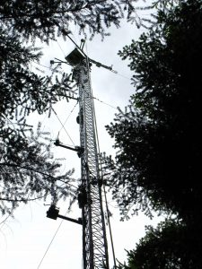
US-MRf Site picture for US-MRf
Keywords: —
Location: California, United States
View in Original Size
To download, right-click photo (Mac: control-click) and choose Save Image As
 US-MRf
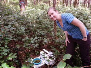
 Whitney Moore with auto soil chamber
Keywords: soil CO2 efflux, Oregon site
Location: United States
View in Original Size
To download, right-click photo (Mac: control-click) and choose Save Image As
US-MRf: Mary's River (Fir) site
- Overview
- Windroses
- Data Citation
- Data Use Log
- Image Gallery
- Remote Sensing Data
- MODIS
- PhenoCam
- GeoNEX
- Publications
- BADM
| AmeriFlux Publications | Add Publication |
| Year | Publication |
|---|---|
| 2021 | Chu, H., Luo, X., Ouyang, Z., Chan, W. S., Dengel, S., Biraud, S. C., Torn, M. S., Metzger, S., Kumar, J., Arain, M. A., Arkebauer, T. J., Baldocchi, D., Bernacchi, C., Billesbach, D., Black, T. A., Blanken, P. D., Bohrer, G., Bracho, R., Brown, S., Brunsell, N. A., Chen, J., Chen, X., Clark, K., Desai, A. R., Duman, T., Durden, D., Fares, S., Forbrich, I., Gamon, J. A., Gough, C. M., Griffis, T., Helbig, M., Hollinger, D., Humphreys, E., Ikawa, H., Iwata, H., Ju, Y., Knowles, J. F., Knox, S. H., Kobayashi, H., Kolb, T., Law, B., Lee, X., Litvak, M., Liu, H., Munger, J. W., Noormets, A., Novick, K., Oberbauer, S. F., Oechel, W., Oikawa, P., Papuga, S. A., Pendall, E., Prajapati, P., Prueger, J., Quinton, W. L., Richardson, A. D., Russell, E. S., Scott, R. L., Starr, G., Staebler, R., Stoy, P. C., Stuart-Haëntjens, E., Sonnentag, O., Sullivan, R. C., Suyker, A., Ueyama, M., Vargas, R., Wood, J. D., Zona, D. (2021) Representativeness Of Eddy-Covariance Flux Footprints For Areas Surrounding Ameriflux Sites, Agricultural And Forest Meteorology, 301-302, 108350. https://doi.org/10.1016/j.agrformet.2021.108350 |
| 2016 | Novick, K. A., Ficklin, D. L., Stoy, P. C., Williams, C. A., Bohrer, G., Oishi, A., Papuga, S. A., Blanken, P. D., Noormets, A., Sulman, B. N., Scott, R. L., Wang, L., Phillips, R. P. (2016) The Increasing Importance Of Atmospheric Demand For Ecosystem Water And Carbon Fluxes, Nature Climate Change, 6(11), 1023-1027. https://doi.org/10.1038/nclimate3114 |
| 2018 | Chu, H., Baldocchi, D. D., Poindexter, C., Abraha, M., Desai, A. R., Bohrer, G., Arain, M. A., Griffis, T., Blanken, P. D., O'Halloran, T. L., Thomas, R. Q., Zhang, Q., Burns, S. P., Frank, J. M., Christian, D., Brown, S., Black, T. A., Gough, C. M., Law, B. E., Lee, X., Chen, J., Reed, D. E., Massman, W. J., Clark, K., Hatfield, J., Prueger, J., Bracho, R., Baker, J. M., Martin, T. A. (2018) Temporal Dynamics Of Aerodynamic Canopy Height Derived From Eddy Covariance Momentum Flux Data Across North American Flux Networks, Geophysical Research Letters, 45, 9275–9287. https://doi.org/10.1029/2018GL079306 |
| 2016 | Schmidt, A., Law, B. E., Göckede, M., Hanson, C., Yang, Z., Conley, S. (2016) Bayesian Optimization Of The Community Land Model Simulated Biosphere–Atmosphere Exchange Using Co2observations From A Dense Tower Network And Aircraft Campaigns Over Oregon, Earth Interactions, 20(22), 1-35. https://doi.org/10.1175/EI-D-16-0011.1 |
| 2018 | Kwon, H., Law, B. E., Thomas, C. K., Johnson, B. G. (2018) The Influence Of Hydrological Variability On Inherent Water Use Efficiency In Forests Of Contrasting Composition, Age, And Precipitation Regimes In The Pacific Northwest, Agricultural And Forest Meteorology, 249, 488-500. https://doi.org/doi:10.1016/j.agrformet.2017.08.006 |
US-MRf: Mary's River (Fir) site
- Overview
- Windroses
- Data Citation
- Data Use Log
- Image Gallery
- Remote Sensing Data
- MODIS
- PhenoCam
- GeoNEX
- Publications
- BADM
BADM for This Site
Access the Biological, Ancillary, Disturbance and Metadata (BADM) information and data for this site.
BADM contain information for many uses, such as characterizing a site’s vegetation and soil, describing disturbance history, and defining instrumentation for flux processing. They complement the flux/met data.
- Download BADM for this site*
- View Site General Info for this site (Overview tab)*
- Use Online Editor to update Site General Info or DOI Authorship
- Update information about submitted data (Variable Information tool)
- More BADM resources
* Online updates are shown on the Overview tab real time. However, downloaded BADM files will not reflect those updates until they have been reviewed for QA/QC.
US-MRf: Mary's River (Fir) site
- Overview
- Windroses
- Data Citation
- Data Use Log
- Image Gallery
- Remote Sensing Data
- MODIS
- PhenoCam
- GeoNEX
- Publications
- BADM
Wind Roses
Wind Speed (m/s)
- Wind Speed Scale: Per Site
- Wind Direction Scale (%): Per Site
- Wind Speed Scale: Non-Linear
- Wind Direction Scale (%): AmeriFlux