
US-MBP: Marcell Bog Lake Peatland
- Overview
- Windroses
- Data Citation
- Data Use Log
- Image Gallery
- Remote Sensing Data
- MODIS
- PhenoCam
- GeoNEX
- Publications
- BADM
| Tower_team: | |
| PI: | Randy Kolka randall.k.kolka@usda.gov - USDA- Forest Service |
| PI: | Timothy Griffis timgriffis@umn.edu - University of Minnesota |
| DataManager: | Caleb Hammer Hamme785@umn.edu - University of Minnesota |
| Lat, Long: | 47.5051, -93.4893 |
| Elevation(m): | 416 |
| Network Affiliations: | AmeriFlux, Phenocam |
| Vegetation IGBP: | WET (Permanent Wetlands: Lands with a permanent mixture of water and herbaceous or woody vegetation that cover extensive areas. The vegetation can be present in either salt, brackish, or fresh water) |
| Climate Koeppen: | — |
| Mean Annual Temp (°C): | 3.4 |
| Mean Annual Precip. (mm): | 780 |
| Flux Species Measured: | CO2, H, H2O, CH4 |
| Years Data Collected: | 2007 - Present |
| Years Data Available: | AmeriFlux BASE 2009 - 2024 Data Citation AmeriFlux FLUXNET 2009 - 2024 Data Citation |
| Data Use Policy: | AmeriFlux CC-BY-4.0 Policy1 |
| Description: | |
| URL: | — |
| Research Topics: | — |
| Acknowledgment: | — |
- This site’s data can also be used under the more restrictive AmeriFlux Legacy Policy.
The AmeriFlux Legacy Policy must be followed if this site’s data are combined with data from sites that require the AmeriFlux Legacy Policy.
Copyright preference: As long as credit is given
US-MBP: Marcell Bog Lake Peatland
- Overview
- Windroses
- Data Citation
- Data Use Log
- Image Gallery
- Remote Sensing Data
- MODIS
- PhenoCam
- GeoNEX
- Publications
- BADM
Use the information below for citation of this site. See the Data Policy page for more details.
DOI(s) for citing US-MBP data
Data Use Policy: AmeriFlux CC-BY-4.0 License
This site’s data can also be used under the more restrictive AmeriFlux Legacy Policy.
The AmeriFlux Legacy Policy must be followed if US-MBP data are combined with data from sites that require the AmeriFlux Legacy Policy.
- AmeriFlux BASE: https://doi.org/10.17190/AMF/1767835
Citation: Tyler Roman, Andrew C. Hill, Randy Kolka, Timothy Griffis, Julian Deventer (2025), AmeriFlux BASE US-MBP Marcell Bog Lake Peatland, Ver. 5-5, AmeriFlux AMP, (Dataset). https://doi.org/10.17190/AMF/1767835 - AmeriFlux FLUXNET: https://doi.org/10.17190/AMF/3027340
Citation: Tyler Roman, Andrew C. Hill, Randy Kolka, Timothy Griffis, Julian Deventer (2026), AmeriFlux FLUXNET-1F US-MBP Marcell Bog Lake Peatland, Ver. v1.3_r1, AmeriFlux AMP, (Dataset). https://doi.org/10.17190/AMF/3027340
Find global FLUXNET datasets, like FLUXNET2015 and FLUXNET-CH4, and their citation information at fluxnet.org.
To cite BADM when downloaded on their own, use the publications below for citing site characterization. When using BADM that are downloaded with AmeriFlux BASE and AmeriFlux FLUXNET products, use the DOI citation for the associated data product.
Publication(s) for citing site characterization
- —
Acknowledgments
- —
Resources
- AmeriFlux Logos & Acknowledgments
US-MBP: Marcell Bog Lake Peatland
- Overview
- Windroses
- Data Citation
- Data Use Log
- Image Gallery
- Remote Sensing Data
- MODIS
- PhenoCam
- GeoNEX
- Publications
- BADM

This page displays the list of downloads of data for the site {{siteId}}.
Note: Results are the number of downloads to distinct data users. The Download Count column indicates the number of times the data user downloaded the data. The Version column refers to the version of the data product for the site that was downloaded by the data user.
| Date | Name | Data Product | Vers. | Intended Use | Intended Use Description | Download Count |
|---|---|---|---|---|---|---|
| {{dlObject.timeStamp}} | {{dlObject.displayName}} | {{displayProduct(dlObject.dataProduct)}} | {{dlObject.version}} | {{dlObject.intendedUse}} | {{dlObject.comment}} | {{dlObject.downloadCounter}} |
Showing {{startItem + 1}} to {{(startItem + items) > filtered.length ? filtered.length : (startItem + items)}} of {{filtered.length}} results
Showing 0 to 0 of 0 results
Not Found
Uh Oh. Something is missing. Try double checking the URL and try again.
US-MBP: Marcell Bog Lake Peatland
- Overview
- Windroses
- Data Citation
- Data Use Log
- Image Gallery
- Remote Sensing Data
- MODIS
- PhenoCam
- GeoNEX
- Publications
- BADM
| AmeriFlux Images | Add Image |
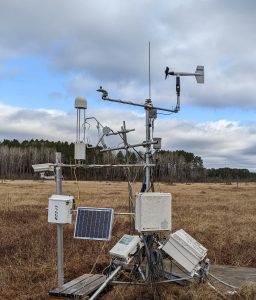 US-MBP
 US-MBP early spring
Keywords: —
Location: Minnesota, United States
View in Original Size
To download, right-click photo (Mac: control-click) and choose Save Image As
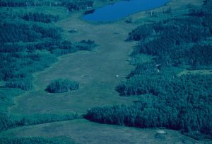 US-MBP
 US_MBP aerial site view
Keywords: —
Location: Minnesota, United States
View in Original Size
To download, right-click photo (Mac: control-click) and choose Save Image As
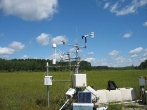
US-MBP Bog Lake Peatland Instrumentation
Keywords: —
Location: Minnesota, United States
View in Original Size
To download, right-click photo (Mac: control-click) and choose Save Image As
US-MBP: Marcell Bog Lake Peatland
- Overview
- Windroses
- Data Citation
- Data Use Log
- Image Gallery
- Remote Sensing Data
- MODIS
- PhenoCam
- GeoNEX
- Publications
- BADM
MODIS NDVI
The time series shows the 16-day Normalized Difference Vegetation Index (NDVI) average from the MOD13Q1 data product.
Use the slider below the time series to zoom in and out.
To view / download these data and other MOD13Q1 products for this site, visit MODIS/Terra Vegetation Indices.
For other related products, visit MODIS/VIIRS Fixed Sites Subsets Tool.
Citation:
ORNL DAAC. 2018. Terrestrial Ecology Subsetting & Visualization Services (TESViS) Fixed Sites Subsets. ORNL DAAC, Oak Ridge, Tennessee, USA. https://doi.org/10.3334/ORNLDAAC/1567
MODIS NDVI subsetted data is not yet available for this site.
For a complete list of AmeriFlux sites, visit ORNL DAAC's MODIS/VIIRS Fixed Sites Subsets Tool.


US-MBP: Marcell Bog Lake Peatland
- Overview
- Windroses
- Data Citation
- Data Use Log
- Image Gallery
- Remote Sensing Data
- MODIS
- PhenoCam
- GeoNEX
- Publications
- BADM
| AmeriFlux Publications | Add Publication |
| Year | Publication |
|---|---|
| 2019 | Deventer, M. J., Griffis, T. J., Roman, D. T., Kolka, R. K., Wood, J. D., Erickson, M., Baker, J. M., Millet, D. B. (2019) Error Characterization Of Methane Fluxes And Budgets Derived From A Long-Term Comparison Of Open- And Closed-Path Eddy Covariance Systems, Agricultural And Forest Meteorology, 278, 107638. https://doi.org/https://doi.org/10.1016/j.agrformet.2019.107638 |
| 2020 | Feng, X., Deventer, M. J., Lonchar, R., Ng, G. H., Sebestyen, S. D., Roman, D. T., Griffis, T. J., Millet, D. B., Kolka, R. K. (2020) Climate Sensitivity Of Peatland Methane Emissions Mediated By Seasonal Hydrologic Dynamics, Geophysical Research Letters, 47(17), . https://doi.org/https://doi.org/10.1029/2020GL088875 |
US-MBP: Marcell Bog Lake Peatland
- Overview
- Windroses
- Data Citation
- Data Use Log
- Image Gallery
- Remote Sensing Data
- MODIS
- PhenoCam
- GeoNEX
- Publications
- BADM
BADM for This Site
Access the Biological, Ancillary, Disturbance and Metadata (BADM) information and data for this site.
BADM contain information for many uses, such as characterizing a site’s vegetation and soil, describing disturbance history, and defining instrumentation for flux processing. They complement the flux/met data.
- Download BADM for this site*
- View Site General Info for this site (Overview tab)*
- Use Online Editor to update Site General Info or DOI Authorship
- Update information about submitted data (Variable Information tool)
- More BADM resources
* Online updates are shown on the Overview tab real time. However, downloaded BADM files will not reflect those updates until they have been reviewed for QA/QC.
US-MBP: Marcell Bog Lake Peatland
- Overview
- Windroses
- Data Citation
- Data Use Log
- Image Gallery
- Remote Sensing Data
- MODIS
- PhenoCam
- GeoNEX
- Publications
- BADM
Wind Roses
Wind Speed (m/s)
- Wind Speed Scale: Per Site
- Wind Direction Scale (%): Per Site
- Wind Speed Scale: Non-Linear
- Wind Direction Scale (%): AmeriFlux