
US-Lin: Lindcove Orange Orchard
- Overview
- Windroses
- Data Citation
- Data Use Log
- Image Gallery
- Remote Sensing Data
- MODIS
- PhenoCam
- GeoNEX
- Publications
- BADM
| Tower_team: | |
| PI: | Silvano Fares silvano.fares@cnr.it - National Research Council of Italy |
| AncContact: | Allen Goldstein ahg@berkeley.edu - University of California, Berkeley |
| FluxContact: | Robin J. Weber rjweber@berkeley.edu - University of California |
| Lat, Long: | 36.3566, -119.0922 |
| Elevation(m): | 131 |
| Network Affiliations: | AmeriFlux |
| Vegetation IGBP: | CRO (Croplands: Lands covered with temporary crops followed by harvest and a bare soil period (e.g., single and multiple cropping systems). Note that perennial woody crops will be classified as the appropriate forest or shrub land cover type.) |
| Climate Koeppen: | — |
| Mean Annual Temp (°C): | — |
| Mean Annual Precip. (mm): | — |
| Flux Species Measured: | CO2 |
| Years Data Collected: | 2009 - 2010 |
| Years Data Available: | AmeriFlux BASE 2009 - 2010 Data Citation AmeriFlux FLUXNET 2009 - 2010 Data Citation |
| Data Use Policy: | AmeriFlux CC-BY-4.0 Policy1 |
| Description: | |
| URL: | — |
| Research Topics: | — |
| Acknowledgment: | — |
- This site’s data can also be used under the more restrictive AmeriFlux Legacy Policy.
The AmeriFlux Legacy Policy must be followed if this site’s data are combined with data from sites that require the AmeriFlux Legacy Policy.
Copyright preference: Open use
US-Lin: Lindcove Orange Orchard
- Overview
- Windroses
- Data Citation
- Data Use Log
- Image Gallery
- Remote Sensing Data
- MODIS
- PhenoCam
- GeoNEX
- Publications
- BADM
Use the information below for citation of this site. See the Data Policy page for more details.
DOI(s) for citing US-Lin data
Data Use Policy: AmeriFlux CC-BY-4.0 License
This site’s data can also be used under the more restrictive AmeriFlux Legacy Policy.
The AmeriFlux Legacy Policy must be followed if US-Lin data are combined with data from sites that require the AmeriFlux Legacy Policy.
- AmeriFlux BASE: https://doi.org/10.17190/AMF/1246830
Citation: Silvano Fares (2019), AmeriFlux BASE US-Lin Lindcove Orange Orchard, Ver. 2-5, AmeriFlux AMP, (Dataset). https://doi.org/10.17190/AMF/1246830 - AmeriFlux FLUXNET: https://doi.org/10.17190/AMF/2229381
Citation: Silvano Fares (2025), AmeriFlux FLUXNET-1F US-Lin Lindcove Orange Orchard, Ver. 5-7, AmeriFlux AMP, (Dataset). https://doi.org/10.17190/AMF/2229381
Find global FLUXNET datasets, like FLUXNET2015 and FLUXNET-CH4, and their citation information at fluxnet.org.
To cite BADM when downloaded on their own, use the publications below for citing site characterization. When using BADM that are downloaded with AmeriFlux BASE and AmeriFlux FLUXNET products, use the DOI citation for the associated data product.
Publication(s) for citing site characterization
- —
Acknowledgments
- —
Resources
- AmeriFlux Logos & Acknowledgments
US-Lin: Lindcove Orange Orchard
- Overview
- Windroses
- Data Citation
- Data Use Log
- Image Gallery
- Remote Sensing Data
- MODIS
- PhenoCam
- GeoNEX
- Publications
- BADM

This page displays the list of downloads of data for the site {{siteId}}.
Note: Results are the number of downloads to distinct data users. The Download Count column indicates the number of times the data user downloaded the data. The Version column refers to the version of the data product for the site that was downloaded by the data user.
| Date | Name | Data Product | Vers. | Intended Use | Intended Use Description | Download Count |
|---|---|---|---|---|---|---|
| {{dlObject.timeStamp}} | {{dlObject.displayName}} | {{displayProduct(dlObject.dataProduct)}} | {{dlObject.version}} | {{dlObject.intendedUse}} | {{dlObject.comment}} | {{dlObject.downloadCounter}} |
Showing {{startItem + 1}} to {{(startItem + items) > filtered.length ? filtered.length : (startItem + items)}} of {{filtered.length}} results
Showing 0 to 0 of 0 results
Not Found
Uh Oh. Something is missing. Try double checking the URL and try again.
US-Lin: Lindcove Orange Orchard
- Overview
- Windroses
- Data Citation
- Data Use Log
- Image Gallery
- Remote Sensing Data
- MODIS
- PhenoCam
- GeoNEX
- Publications
- BADM
| AmeriFlux Images | Add Image |
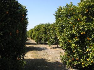
US-Lin View of the orchard
Keywords: —
Location: California, United States
View in Original Size
To download, right-click photo (Mac: control-click) and choose Save Image As
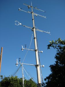 US-Lin
 Mobile tower with several inlets
Keywords: —
Location: California, United States
View in Original Size
To download, right-click photo (Mac: control-click) and choose Save Image As
US-Lin: Lindcove Orange Orchard
- Overview
- Windroses
- Data Citation
- Data Use Log
- Image Gallery
- Remote Sensing Data
- MODIS
- PhenoCam
- GeoNEX
- Publications
- BADM
| AmeriFlux Publications | Add Publication |
| Year | Publication |
|---|---|
| 2021 | Chu, H., Luo, X., Ouyang, Z., Chan, W. S., Dengel, S., Biraud, S. C., Torn, M. S., Metzger, S., Kumar, J., Arain, M. A., Arkebauer, T. J., Baldocchi, D., Bernacchi, C., Billesbach, D., Black, T. A., Blanken, P. D., Bohrer, G., Bracho, R., Brown, S., Brunsell, N. A., Chen, J., Chen, X., Clark, K., Desai, A. R., Duman, T., Durden, D., Fares, S., Forbrich, I., Gamon, J. A., Gough, C. M., Griffis, T., Helbig, M., Hollinger, D., Humphreys, E., Ikawa, H., Iwata, H., Ju, Y., Knowles, J. F., Knox, S. H., Kobayashi, H., Kolb, T., Law, B., Lee, X., Litvak, M., Liu, H., Munger, J. W., Noormets, A., Novick, K., Oberbauer, S. F., Oechel, W., Oikawa, P., Papuga, S. A., Pendall, E., Prajapati, P., Prueger, J., Quinton, W. L., Richardson, A. D., Russell, E. S., Scott, R. L., Starr, G., Staebler, R., Stoy, P. C., Stuart-Haëntjens, E., Sonnentag, O., Sullivan, R. C., Suyker, A., Ueyama, M., Vargas, R., Wood, J. D., Zona, D. (2021) Representativeness Of Eddy-Covariance Flux Footprints For Areas Surrounding Ameriflux Sites, Agricultural And Forest Meteorology, 301-302, 108350. https://doi.org/10.1016/j.agrformet.2021.108350 |
| 2013 | Fares, S., Vargas, R., Detto, M., Goldstein, A. H., Karlik, J., Paoletti, E., Vitale, M. (2013) Tropospheric Ozone Reduces Carbon Assimilation In Trees: Estimates From Analysis Of Continuous Flux Measurements, Global Change Biology, 19(8), 2427-2443. https://doi.org/10.1111/gcb.12222 |
| 2012 | Fares, S., Weber, R., Park, J., Gentner, D., Karlik, J., Goldstein, A. H. (2012) Ozone Deposition To An Orange Orchard: Partitioning Between Stomatal And Non-Stomatal Sinks, Environmental Pollution, 169, 258-266. https://doi.org/10.1016/j.envpol.2012.01.030 |
| 2012 | Fares, S., Weber, R., Park, J., Gentner, D., Karlik, J., Goldstein, A. H. (2012) Ozone Deposition To An Orange Orchard: Partitioning Between Stomatal And Non-Stomatal Sinks, Environmental Pollution, 169, 258-266. https://doi.org/10.1016/j.envpol.2012.01.030 |
US-Lin: Lindcove Orange Orchard
- Overview
- Windroses
- Data Citation
- Data Use Log
- Image Gallery
- Remote Sensing Data
- MODIS
- PhenoCam
- GeoNEX
- Publications
- BADM
BADM for This Site
Access the Biological, Ancillary, Disturbance and Metadata (BADM) information and data for this site.
BADM contain information for many uses, such as characterizing a site’s vegetation and soil, describing disturbance history, and defining instrumentation for flux processing. They complement the flux/met data.
- Download BADM for this site*
- View Site General Info for this site (Overview tab)*
- Use Online Editor to update Site General Info or DOI Authorship
- Update information about submitted data (Variable Information tool)
- More BADM resources
* Online updates are shown on the Overview tab real time. However, downloaded BADM files will not reflect those updates until they have been reviewed for QA/QC.
US-Lin: Lindcove Orange Orchard
- Overview
- Windroses
- Data Citation
- Data Use Log
- Image Gallery
- Remote Sensing Data
- MODIS
- PhenoCam
- GeoNEX
- Publications
- BADM
Wind Roses
Wind Speed (m/s)
- Wind Speed Scale: Per Site
- Wind Direction Scale (%): Per Site
- Wind Speed Scale: Non-Linear
- Wind Direction Scale (%): AmeriFlux