
US-ICs: Imnavait Creek Watershed Wet Sedge Tundra
- Overview
- Windroses
- Data Citation
- Data Use Log
- Image Gallery
- Remote Sensing Data
- MODIS
- PhenoCam
- GeoNEX
- Publications
- BADM
| Tower_team: | |
| PI: | Eugenie Euskirchen seeuskirchen@alaska.edu - University of Alaska Fairbanks |
| PI: | Syndonia Bret-Harte msbretharte@alaska.edu - University of Alaska Fairbanks |
| FluxContact: | Colin Edgar cedgar3@alaska.edu - University of Alaska Fairbanks |
| Lat, Long: | 68.6058, -149.3110 |
| Elevation(m): | 920 |
| Network Affiliations: | AmeriFlux, Phenocam |
| Vegetation IGBP: | WET (Permanent Wetlands: Lands with a permanent mixture of water and herbaceous or woody vegetation that cover extensive areas. The vegetation can be present in either salt, brackish, or fresh water) |
| Climate Koeppen: | ET (Tundra) |
| Mean Annual Temp (°C): | -7.4 |
| Mean Annual Precip. (mm): | 318 |
| Flux Species Measured: | CO2, CH4 |
| Years Data Collected: | 2007 - Present |
| Years Data Available: | AmeriFlux BASE 2007 - 2025 Data Citation AmeriFlux FLUXNET 2007 - 2024 Data Citation |
| Data Use Policy: | AmeriFlux CC-BY-4.0 Policy1 |
| Description: | |
| URL: | http://aon.iab.uaf.edu/imnavait |
| Research Topics: | |
| Acknowledgment: | — |
- This site’s data can also be used under the more restrictive AmeriFlux Legacy Policy.
The AmeriFlux Legacy Policy must be followed if this site’s data are combined with data from sites that require the AmeriFlux Legacy Policy.
Copyright preference: Open use
US-ICs: Imnavait Creek Watershed Wet Sedge Tundra
- Overview
- Windroses
- Data Citation
- Data Use Log
- Image Gallery
- Remote Sensing Data
- MODIS
- PhenoCam
- GeoNEX
- Publications
- BADM
Use the information below for citation of this site. See the Data Policy page for more details.
DOI(s) for citing US-ICs data
Data Use Policy: AmeriFlux CC-BY-4.0 License
This site’s data can also be used under the more restrictive AmeriFlux Legacy Policy.
The AmeriFlux Legacy Policy must be followed if US-ICs data are combined with data from sites that require the AmeriFlux Legacy Policy.
- AmeriFlux BASE: https://doi.org/10.17190/AMF/1246130
Citation: Eugenie Euskirchen, Gaius Shaver, Syndonia Bret-Harte (2025), AmeriFlux BASE US-ICs Imnavait Creek Watershed Wet Sedge Tundra, Ver. 12-5, AmeriFlux AMP, (Dataset). https://doi.org/10.17190/AMF/1246130 - AmeriFlux FLUXNET: https://doi.org/10.17190/AMF/1871138
Citation: Eugenie Euskirchen, Gaius Shaver, Syndonia Bret-Harte (2025), AmeriFlux FLUXNET-1F US-ICs Imnavait Creek Watershed Wet Sedge Tundra, Ver. 5-7, AmeriFlux AMP, (Dataset). https://doi.org/10.17190/AMF/1871138
Find global FLUXNET datasets, like FLUXNET2015 and FLUXNET-CH4, and their citation information at fluxnet.org.
To cite BADM when downloaded on their own, use the publications below for citing site characterization. When using BADM that are downloaded with AmeriFlux BASE and AmeriFlux FLUXNET products, use the DOI citation for the associated data product.
Publication(s) for citing site characterization
- —
Acknowledgments
- —
Resources
- AmeriFlux Logos & Acknowledgments
US-ICs: Imnavait Creek Watershed Wet Sedge Tundra
- Overview
- Windroses
- Data Citation
- Data Use Log
- Image Gallery
- Remote Sensing Data
- MODIS
- PhenoCam
- GeoNEX
- Publications
- BADM

This page displays the list of downloads of data for the site {{siteId}}.
Note: Results are the number of downloads to distinct data users. The Download Count column indicates the number of times the data user downloaded the data. The Version column refers to the version of the data product for the site that was downloaded by the data user.
| Date | Name | Data Product | Vers. | Intended Use | Intended Use Description | Download Count |
|---|---|---|---|---|---|---|
| {{dlObject.timeStamp}} | {{dlObject.displayName}} | {{displayProduct(dlObject.dataProduct)}} | {{dlObject.version}} | {{dlObject.intendedUse}} | {{dlObject.comment}} | {{dlObject.downloadCounter}} |
Showing {{startItem + 1}} to {{(startItem + items) > filtered.length ? filtered.length : (startItem + items)}} of {{filtered.length}} results
Showing 0 to 0 of 0 results
Not Found
Uh Oh. Something is missing. Try double checking the URL and try again.
US-ICs: Imnavait Creek Watershed Wet Sedge Tundra
- Overview
- Windroses
- Data Citation
- Data Use Log
- Image Gallery
- Remote Sensing Data
- MODIS
- PhenoCam
- GeoNEX
- Publications
- BADM
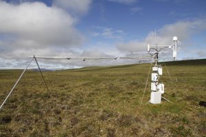
| AmeriFlux Images | Add Image |
US-ICs Eddy covariance tower
Keywords: —
Location: Alaska, United States
View in Original Size
To download, right-click photo (Mac: control-click) and choose Save Image As
US-ICs: Imnavait Creek Watershed Wet Sedge Tundra
- Overview
- Windroses
- Data Citation
- Data Use Log
- Image Gallery
- Remote Sensing Data
- MODIS
- PhenoCam
- GeoNEX
- Publications
- BADM
MODIS NDVI
The time series shows the 16-day Normalized Difference Vegetation Index (NDVI) average from the MOD13Q1 data product.
Use the slider below the time series to zoom in and out.
To view / download these data and other MOD13Q1 products for this site, visit MODIS/Terra Vegetation Indices.
For other related products, visit MODIS/VIIRS Fixed Sites Subsets Tool.
Citation:
ORNL DAAC. 2018. Terrestrial Ecology Subsetting & Visualization Services (TESViS) Fixed Sites Subsets. ORNL DAAC, Oak Ridge, Tennessee, USA. https://doi.org/10.3334/ORNLDAAC/1567
MODIS NDVI subsetted data is not yet available for this site.
For a complete list of AmeriFlux sites, visit ORNL DAAC's MODIS/VIIRS Fixed Sites Subsets Tool.


US-ICs: Imnavait Creek Watershed Wet Sedge Tundra
- Overview
- Windroses
- Data Citation
- Data Use Log
- Image Gallery
- Remote Sensing Data
- MODIS
- PhenoCam
- GeoNEX
- Publications
- BADM
| AmeriFlux Publications | Add Publication |
| Year | Publication |
|---|---|
| 2022 | Oehri, J., Schaepman-Strub, G., Kim, J., Grysko, R., Kropp, H., Grünberg, I., Zemlianskii, V., Sonnentag, O., Euskirchen, E. S., Reji Chacko, M., Muscari, G., Blanken, P. D., Dean, J. F., di Sarra, A., Harding, R. J., Sobota, I., Kutzbach, L., Plekhanova, E., Riihelä, A., Boike, J., Miller, N. B., Beringer, J., López-Blanco, E., Stoy, P. C., Sullivan, R. C., Kejna, M., Parmentier, F. W., Gamon, J. A., Mastepanov, M., Wille, C., Jackowicz-Korczynski, M., Karger, D. N., Quinton, W. L., Putkonen, J., van As, D., Christensen, T. R., Hakuba, M. Z., Stone, R. S., Metzger, S., Vandecrux, B., Frost, G. V., Wild, M., Hansen, B., Meloni, D., Domine, F., te Beest, M., Sachs, T., Kalhori, A., Rocha, A. V., Williamson, S. N., Morris, S., Atchley, A. L., Essery, R., Runkle, B. R., Holl, D., Riihimaki, L. D., Iwata, H., Schuur, E. A., Cox, C. J., Grachev, A. A., McFadden, J. P., Fausto, R. S., Göckede, M., Ueyama, M., Pirk, N., de Boer, G., Bret-Harte, M. S., Leppäranta, M., Steffen, K., Friborg, T., Ohmura, A., Edgar, C. W., Olofsson, J., Chambers, S. D. (2022) Vegetation Type Is An Important Predictor Of The Arctic Summer Land Surface Energy Budget, Nature Communications, 13(1), . https://doi.org/10.1038/s41467-022-34049-3 |
| 2017 | Euskirchen, E. S., Bret-Harte, M. S., Shaver, G. R., Edgar, C. W., Romanovsky, V. E. (2017) Long-Term Release Of Carbon Dioxide From Arctic Tundra Ecosystems In Alaska, Ecosystems, 20(5), 960-974. https://doi.org/https://dx.doi.org/10.1007/s10021-016-0085-9 |
| 2018 | Qiu, C., Zhu, D., Ciais, P., Guenet, B., Krinner, G., Peng, S., Aurela, M., Bernhofer, C., Brümmer, C., Bret-Harte, S., Chu, H., Chen, J., Desai, A. R., Dušek, J., Euskirchen, E. S., Fortuniak, K., Flanagan, L. B., Friborg, T., Grygoruk, M., Gogo, S., Grünwald, T., Hansen, B. U., Holl, D., Humphreys, E., Hurkuck, M., Kiely, G., Klatt, J., Kutzbach, L., Largeron, C., Laggoun-Défarge, F., Lund, M., Lafleur, P. M., Li, X., Mammarella, I., Merbold, L., Nilsson, M. B., Olejnik, J., Ottosson-Löfvenius, M., Oechel, W., Parmentier, F. W., Peichl, M., Pirk, N., Peltola, O., Pawlak, W., Rasse, D., Rinne, J., Shaver, G., Schmid, H. P., Sottocornola, M., Steinbrecher, R., Sachs, T., Urbaniak, M., Zona, D., Ziemblinska, K. (2018) Orchidee-Peat (Revision 4596), A Model For Northern Peatland Co≪Sub≫2≪/Sub≫, Water, And Energy Fluxes On Daily To Annual Scales, Geoscientific Model Development, 11(2), 497-519. https://doi.org/10.5194/gmd-11-497-2018 |
| 2012 | Euskirchen, E. S., Bret-Harte, M. S., Scott, G. J., Edgar, C., Shaver, G. R. (2012) Seasonal Patterns Of Carbon Dioxide And Water Fluxes In Three Representative Tundra Ecosystems In Northern Alaska, Ecosphere, 3(1), 1-19. https://doi.org/10.1890/ES11-00202.1 |
| 2012 | Kade, A., Bret-Harte, M. S., Euskirchen, E. S., Edgar, C., Fulweber, R. A. (2012) Upscaling Of CO2 Fluxes From Heterogeneous Tundra Plant Communities In Arctic Alaska, Journal Of Geophysical Research: Biogeosciences, 117(G4), n/a-n/a. https://doi.org/10.1029/2012JG002065 |
US-ICs: Imnavait Creek Watershed Wet Sedge Tundra
- Overview
- Windroses
- Data Citation
- Data Use Log
- Image Gallery
- Remote Sensing Data
- MODIS
- PhenoCam
- GeoNEX
- Publications
- BADM
BADM for This Site
Access the Biological, Ancillary, Disturbance and Metadata (BADM) information and data for this site.
BADM contain information for many uses, such as characterizing a site’s vegetation and soil, describing disturbance history, and defining instrumentation for flux processing. They complement the flux/met data.
- Download BADM for this site*
- View Site General Info for this site (Overview tab)*
- Use Online Editor to update Site General Info or DOI Authorship
- Update information about submitted data (Variable Information tool)
- More BADM resources
* Online updates are shown on the Overview tab real time. However, downloaded BADM files will not reflect those updates until they have been reviewed for QA/QC.
US-ICs: Imnavait Creek Watershed Wet Sedge Tundra
- Overview
- Windroses
- Data Citation
- Data Use Log
- Image Gallery
- Remote Sensing Data
- MODIS
- PhenoCam
- GeoNEX
- Publications
- BADM
Wind Roses
Wind Speed (m/s)
- Wind Speed Scale: Per Site
- Wind Direction Scale (%): Per Site
- Wind Speed Scale: Non-Linear
- Wind Direction Scale (%): AmeriFlux