
US-HRP: Herring River Phragmites
- Overview
- Windroses
- Data Citation
- Data Use Log
- Image Gallery
- Remote Sensing Data
- MODIS
- PhenoCam
- GeoNEX
- Publications
- BADM
| Tower_team: | |
| PI: | Kevin Kroeger kkroeger@usgs.gov - USGS Woods Hole Center |
| PI: | Meagan Eagle meagle@usgs.gov - USGS Woods Hole Coastal & Marine Science Center |
| DataManager: | Amy Farris afarris@usgs.gov - USGS Woods Hole Coastal & Marine Science Center |
| Lat, Long: | 41.9380, -70.0552 |
| Elevation(m): | 0.5 |
| Network Affiliations: | AmeriFlux |
| Vegetation IGBP: | WET (Permanent Wetlands: Lands with a permanent mixture of water and herbaceous or woody vegetation that cover extensive areas. The vegetation can be present in either salt, brackish, or fresh water) |
| Climate Koeppen: | Dfb (Warm Summer Continental: significant precipitation in all seasons ) |
| Mean Annual Temp (°C): | 9.9 |
| Mean Annual Precip. (mm): | 1195 |
| Flux Species Measured: | CO2, CH4, H2O |
| Years Data Collected: | 2017 - 2022 |
| Years Data Available: | No data available |
| Data Use Policy: | AmeriFlux CC-BY-4.0 Policy1 |
| Description: | |
| URL: | https://www.sciencebase.gov/catalog/item/625880b7d34e21f82770a19b |
| Research Topics: | Studying carbon and water fluxes in a brackish wetland. |
| Acknowledgment: | This research was initially funded by the NOAA National Estuarine Research Reserve Science Collaborative (NA09NOS4190153 and NA14NOS4190145) and NSF MRI (DBI-959333). Current funding is USGS Coastal & Marine Hazards and Resources Program. |
- This site’s data can also be used under the more restrictive AmeriFlux Legacy Policy.
The AmeriFlux Legacy Policy must be followed if this site’s data are combined with data from sites that require the AmeriFlux Legacy Policy.
Copyright preference: Open use
US-HRP: Herring River Phragmites
- Overview
- Windroses
- Data Citation
- Data Use Log
- Image Gallery
- Remote Sensing Data
- MODIS
- PhenoCam
- GeoNEX
- Publications
- BADM
Use the information below for citation of this site. See the Data Policy page for more details.
DOI(s) for citing US-HRP data
Data Use Policy: AmeriFlux CC-BY-4.0 License
- No DOIs available for US-HRP
To cite BADM downloaded as a BIF file, use the publications listed below.
Publication(s) for citing site characterization
- —
Acknowledgments
- —
Resources
- AmeriFlux Logos & Acknowledgments
US-HRP: Herring River Phragmites
- Overview
- Windroses
- Data Citation
- Data Use Log
- Image Gallery
- Remote Sensing Data
- MODIS
- PhenoCam
- GeoNEX
- Publications
- BADM

This page displays the list of downloads of data for the site {{siteId}}.
Note: Results are the number of downloads to distinct data users. The Download Count column indicates the number of times the data user downloaded the data. The Version column refers to the version of the data product for the site that was downloaded by the data user.
| Date | Name | Data Product | Vers. | Intended Use | Intended Use Description | Download Count |
|---|---|---|---|---|---|---|
| {{dlObject.timeStamp}} | {{dlObject.displayName}} | {{displayProduct(dlObject.dataProduct)}} | {{dlObject.version}} | {{dlObject.intendedUse}} | {{dlObject.comment}} | {{dlObject.downloadCounter}} |
Showing {{startItem + 1}} to {{(startItem + items) > filtered.length ? filtered.length : (startItem + items)}} of {{filtered.length}} results
Showing 0 to 0 of 0 results
Not Found
Uh Oh. Something is missing. Try double checking the URL and try again.
US-HRP: Herring River Phragmites
- Overview
- Windroses
- Data Citation
- Data Use Log
- Image Gallery
- Remote Sensing Data
- MODIS
- PhenoCam
- GeoNEX
- Publications
- BADM
| AmeriFlux Images | Add Image |
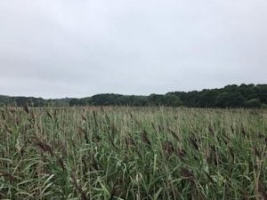
US-HRP Herring River Phragmites
Photograph of a Phragmites wetland in the Herring River estuary in Wellfleet, MA
Keywords: —
Location: Massachusetts, United States
View in Original Size
To download, right-click photo (Mac: control-click) and choose Save Image As
US-HRP: Herring River Phragmites
- Overview
- Windroses
- Data Citation
- Data Use Log
- Image Gallery
- Remote Sensing Data
- MODIS
- PhenoCam
- GeoNEX
- Publications
- BADM
| AmeriFlux Publications | Add Publication |
| Year | Publication |
|---|---|
| 2022 | Sanders‐DeMott, R., Eagle, M. J., Kroeger, K. D., Wang, F., Brooks, T. W., O'Keefe Suttles, J. A., Nick, S. K., Mann, A. G., Tang, J. (2022) Impoundment Increases Methane Emissions In Phragmites‐Invaded Coastal Wetlands, Global Change Biology, . https://doi.org/https://doi.org/10.1111/gcb.16217 |
US-HRP: Herring River Phragmites
- Overview
- Windroses
- Data Citation
- Data Use Log
- Image Gallery
- Remote Sensing Data
- MODIS
- PhenoCam
- GeoNEX
- Publications
- BADM
BADM for This Site
Access the Biological, Ancillary, Disturbance and Metadata (BADM) information and data for this site.
BADM contain information for many uses, such as characterizing a site’s vegetation and soil, describing disturbance history, and defining instrumentation for flux processing. They complement the flux/met data.
- Download BADM for this site*
- View Site General Info for this site (Overview tab)*
- Use Online Editor to update Site General Info or DOI Authorship
- Update information about submitted data (Variable Information tool)
- More BADM resources
* Online updates are shown on the Overview tab real time. However, downloaded BADM files will not reflect those updates until they have been reviewed for QA/QC.
US-HRP: Herring River Phragmites
- Overview
- Windroses
- Data Citation
- Data Use Log
- Image Gallery
- Remote Sensing Data
- MODIS
- PhenoCam
- GeoNEX
- Publications
- BADM