US-EKH: Elkhorn Slough Hester Marsh
- Overview
- Windroses
- Data Citation
- Data Use Log
- Image Gallery
- Remote Sensing Data
- MODIS
- PhenoCam
- GeoNEX
- Publications
- BADM
Tower_team: | |
PI: | Adina Paytan apaytan@ucsc.edu - University of California, Santa Cruz |
FluxContact: | Sylvain Labedens slabeden@ucsc.edu - University of California, Santa Cruz |
Technician: | J.J. Jabuka jjabuka@ucsd.edu - University of California, Santa Cruz |
Lat, Long: | 36.8094, -121.7523 |
Elevation(m): | 0.5 |
Network Affiliations: | AmeriFlux |
Vegetation IGBP: | WET (Permanent Wetlands: Lands with a permanent mixture of water and herbaceous or woody vegetation that cover extensive areas. The vegetation can be present in either salt, brackish, or fresh water) |
Climate Koeppen: | Csb (Mediterranean: mild with dry, warm summer) |
Mean Annual Temp (°C): | 10 |
Mean Annual Precip. (mm): | 894 |
Flux Species Measured: | CO2, CH4, H2O |
Years Data Collected: | 2022 - Present |
Years Data Available: | AmeriFlux BASE 2022 - 2025 Data Citation |
Data Use Policy: | AmeriFlux CC-BY-4.0 Policy1 |
Description: | Salt marsh restored in 2018 by adding soil to raise 61 acres of former salt marsh to an elevation that allows marsh plants to return and keep pace with ... Salt marsh restored in 2018 by adding soil to raise 61 acres of former salt marsh to an elevation that allows marsh plants to return and keep pace with projected sea level rise. Marsh is mostly bare soil and tidal channels. Marsh is flooded and drained diurnally. See MoreShow Less |
URL: | — |
Research Topics: | Greenhouse gas emissions from restored marshes and how they might change throughout the restoration process. |
Acknowledgment: | — |
- This site’s data can also be used under the more restrictive AmeriFlux Legacy Policy.
The AmeriFlux Legacy Policy must be followed if this site’s data are combined with data from sites that require the AmeriFlux Legacy Policy.


Copyright preference: As long as credit is given
US-EKH: Elkhorn Slough Hester Marsh
- Overview
- Windroses
- Data Citation
- Data Use Log
- Image Gallery
- Remote Sensing Data
- MODIS
- PhenoCam
- GeoNEX
- Publications
- BADM
Use the information below for citation of this site. See the Data Policy page for more details.
DOI(s) for citing US-EKH data
Data Use Policy: AmeriFlux CC-BY-4.0 License
This site’s data can also be used under the more restrictive AmeriFlux Legacy Policy.
The AmeriFlux Legacy Policy must be followed if US-EKH data are combined with data from sites that require the AmeriFlux Legacy Policy.
- AmeriFlux BASE: https://doi.org/10.17190/AMF/2479624
Citation: Adina Paytan (2025), AmeriFlux BASE US-EKH Elkhorn Slough Hester Marsh, Ver. 2-5, AmeriFlux AMP, (Dataset). https://doi.org/10.17190/AMF/2479624
To cite BADM when downloaded on their own, use the publications below for citing site characterization. When using BADM that are downloaded with AmeriFlux BASE and AmeriFlux FLUXNET products, use the DOI citation for the associated data product.
Publication(s) for citing site characterization
- —
Acknowledgments
- —
Resources
- AmeriFlux Logos & Acknowledgments
US-EKH: Elkhorn Slough Hester Marsh
- Overview
- Windroses
- Data Citation
- Data Use Log
- Image Gallery
- Remote Sensing Data
- MODIS
- PhenoCam
- GeoNEX
- Publications
- BADM

This page displays the list of downloads of data for the site US-EKH.
Note: Results are the number of downloads to distinct data users. The Download Count column indicates the number of times the data user downloaded the data. The Version column refers to the version of the data product for the site that was downloaded by the data user.
Date | Name | Data Product | Version | Intended Use | Intended Use Description | Download Count |
---|---|---|---|---|---|---|
2025-03-28 | Kiran Vijayakumar Menon | AmeriFlux BASE | 2-5 | Research - Other | Analyzing the effect of NDVI on soil heat flux. Research work as part of PhD. | 1 |
2025-03-26 | Anne Voigtlaender | AmeriFlux BASE | 2-5 | Research - Other | Compare flux to Earthquake data | 1 |
2025-03-25 | Jinxia Zhang | AmeriFlux BASE | 2-5 | Other | I hope this email finds you well. I am writing to request access to the AMERIFLUX dataset. My purpose is to use this data to validate the accuracy of the evaporation data from the GLEAM4.2 product. This validation will help assess the reliability of GLEAM4.2 in estimating evaporation across different regions. | 1 |
2025-03-23 | babak safa | AmeriFlux BASE | 2-5 | Research - Multi-site synthesis | Research | 1 |
2025-03-18 | Jingyi Bu | AmeriFlux BASE | 1-5 | Research - Remote sensing | Upscaling of eddy covariance measurements from point to continental scale. | 2 |
2025-03-13 | Sophie Hoffman | AmeriFlux BASE | 1-5 | Research - Multi-site synthesis | GPP modeling | 1 |
2025-03-13 | Heine Nygard Riise | AmeriFlux BASE | 1-5 | Research - Remote sensing | Remote sensing of albedo for PV site selection. Validation of empirical model for Sentinel-2 MSI bands | 2 |
2025-03-11 | Yanzu Wu | AmeriFlux BASE | 1-5 | Other | 遥感 | 1 |
2025-03-11 | Xinming Zhu | AmeriFlux BASE | 1-5 | Research - Remote sensing | Inversion research of surface temperature under cloud and sky conditions | 3 |
2025-03-11 | Kai Z | AmeriFlux BASE | 1-5 | Research - Remote sensing | LST | 8 |
2025-03-10 | congli tan | AmeriFlux BASE | 1-5 | Research - Land model/Earth system model | I want to use these data for the research on evapotranspiration. | 2 |
2025-03-04 | Habtamu Tamiru | AmeriFlux BASE | 1-5 | Research - Multi-site synthesis | I want to use these ET estimates to evaluate the ET estimated in my current study using Budyko functional equations. | 1 |
2025-03-03 | Hector Nieto Solana | AmeriFlux BASE | 1-5 | Research - Remote sensing | Validation of Thermal-based energy balance TSEB model using Earth Observation imagery | 1 |
2025-03-02 | Jiatong Gu | AmeriFlux BASE | 1-5 | Other | scientific research | 1 |
2025-03-02 | Mukesh Kumar Mehla | AmeriFlux BASE | 1-5 | Research - Multi-site synthesis | Data would be used for development and vlaidation CH4 emission model for SWAT | 2 |
2025-02-28 | Taylor Smith | AmeriFlux BASE | 1-5 | Research - Multi-site synthesis | Exploratory Research on flux changes | 1 |
2025-02-27 | Mengtao Ci | AmeriFlux BASE | 1-5 | Research - Remote sensing | I plan to carry out a study on global evapotranspiration with the main objective of global evapotranspiration data fusion from 1982 to 2023 using latent heat flux data in combination with other remote sensing and meteorological data. As an important component of the global water cycle and climate system, evapotranspiration directly affects the distribution and variability of regional and global water resources. Therefore, accurate assessment and understanding of spatial and temporal changes in ET is important for climate change research, water resources management and ecosystem monitoring. | 1 |
2025-02-25 | Michael Goulden | AmeriFlux BASE | 1-5 | Research - Land model/Earth system model | Remote sensing and development of GPP/AET regression models. | 1 |
2025-02-25 | Lingcheng Li | AmeriFlux BASE | 1-5 | Research - Multi-site synthesis | compare with model simulations | 1 |
2025-02-24 | Jing Peiqing | AmeriFlux BASE | 1-5 | Other | Assessing terrestrial ecosystem resilience based on remotely sensed data, wanting to use site data as ground validation | 2 |
2025-02-24 | Fa Li | AmeriFlux BASE | 1-5 | Research - Multi-site synthesis | Gap-fill | 2 |
2025-02-24 | Feng Wang | AmeriFlux BASE | 1-5 | Research - Multi-site synthesis | The data will be used for a study focusing on tree growth monitoring across the US. | 1 |
2025-02-24 | ammara talib | AmeriFlux BASE | 1-5 | Research - Land model/Earth system model | salinity effect on WUE, mutisynthesis [amerifluxr download] | 4 |
2025-02-21 | Jeffrey Wood | AmeriFlux BASE | 1-5 | Research - Multi-site synthesis | collecting to preserve for possible future use | 1 |
2025-02-20 | QING ZHU | AmeriFlux BASE | 1-5 | Research - Land model/Earth system model | compare with model | 1 |
2025-02-19 | Anne Voigtlaender | AmeriFlux BASE | 1-5 | Research - Other | Compare flux data to seismicity and later microseismic stations in the Elkhornslough | 1 |
2025-02-19 | Hirofumi Hashimoto | AmeriFlux BASE | 1-5 | Research - Remote sensing | Validation for ecosystem model based on remote sensing | 1 |
2025-02-18 | Han SangHoon | AmeriFlux BASE | 1-5 | Research - Remote sensing | AmeriFlux Network: | 1 |
2025-02-18 | Kyle T Lunneberg | AmeriFlux BASE | 1-5 | Research - Multi-site synthesis | Viewing Data, No intended usages yet. We will reach out if this data is to be implemented | 1 |
2025-02-18 | Shiyuan Wang | AmeriFlux BASE | 1-5 | Other | STUDY | 1 |
2025-02-18 | Ziyu Lin | AmeriFlux BASE | 1-5 | Research - Land model/Earth system model | GPP modelling | 1 |
2025-02-14 | du peng | AmeriFlux BASE | 1-5 | Research - Remote sensing | https://ameriflux.lbl.gov/data/download-data/ | 10 |
2025-02-13 | Isla Simpson | AmeriFlux BASE | 1-5 | Research - Land model/Earth system model | Comparing water availability in ESMs with ameriflux data. | 1 |
2025-02-13 | Kesondra Key | AmeriFlux BASE | 1-5 | Research - Other | Data back up for safe keeping | 1 |
2025-02-13 | Kim Novick | AmeriFlux BASE | 1-5 | Research - Multi-site synthesis | Local data backup, just in case. | 1 |
2025-02-08 | (unknown user_id) | AmeriFlux BASE | 1-5 | Other | caculate ET | 1 |
2025-02-05 | MA MENG IN | AmeriFlux BASE | 1-5 | Research - Remote sensing | for school competition use | 1 |
2025-02-01 | huang duan | AmeriFlux BASE | 1-5 | Research - Multi-site synthesis | Exploring the spatiotemporal changes and remote sensing modeling of global carbon water flux using multi site data. | 1 |
2025-01-31 | Yinan He | AmeriFlux BASE | 1-5 | Research - Remote sensing | to analyze flux for forest | 1 |
2025-01-28 | Elijah Walker | AmeriFlux BASE | 1-5 | Research - Land model/Earth system model | Analyzing GHG gases spatio-temporally to understand its impacts on ecosystem | 1 |
2025-01-27 | Camille Blevins | AmeriFlux BASE | 1-5 | Research - Multi-site synthesis | Comparison of Site base data. | 1 |
2025-01-21 | Fengfei Xin | AmeriFlux BASE | 1-5 | Research - Remote sensing | using eddy covirovance data to model the primary production in remote sensing method | 1 |
2025-01-21 | Ashley Brereton | AmeriFlux BASE | 1-5 | Research - Land model/Earth system model | Deep learning | 1 |
2025-01-20 | Mohamed Hedi Rhouma | AmeriFlux BASE | 1-5 | Research - Remote sensing | to estimate eta | 1 |
2025-01-08 | Jingfeng Xiao | AmeriFlux BASE | 1-5 | Research - Remote sensing | evaluate remotely sensed indices. | 1 |
2025-01-08 | prasad N | AmeriFlux BASE | 1-5 | Research - Remote sensing | Research purpose | 2 |
2025-01-06 | Brandon Norton Benton | AmeriFlux BASE | 1-5 | Research - Land model/Earth system model | Used in wind model training and validation. Model is used to generate high-resolution wind data for wind resource adequacy analysis. | 1 |
2025-01-04 | Cheng Gao | AmeriFlux BASE | 1-5 | Research - Land model/Earth system model | For model validation. | 1 |
2025-01-03 | Yi Xu | AmeriFlux BASE | 1-5 | Research - Land model/Earth system model | coastal wetland modeling (UCSC) | 2 |
2024-12-26 | Xinqu Wu | AmeriFlux BASE | 1-5 | Research - Multi-site synthesis | other | 3 |
2024-12-25 | Pushpendra Raghav | AmeriFlux BASE | 1-5 | Research - Remote sensing | validate the model of ET estimation [amerifluxr download] | 1 |
2024-12-24 | Aolin Jia | AmeriFlux BASE | 1-5 | Research - Remote sensing | valdiating GOES-R all-sky land surface temperature product | 1 |
2024-12-19 | Saeed Roozbeh | AmeriFlux BASE | 1-5 | Research - Remote sensing | im student of politecnico di milano university and im using this data in order to do a reserch on Evapotranspiration on US vineyard. its my thesis. thanks | 1 |
2024-12-17 | ying sun 100 | AmeriFlux BASE | 1-5 | Research - Other | Build a model using global methane flux data to explore the role of methane in global climate change. | 1 |
2024-12-12 | Pei Wang | AmeriFlux BASE | 1-5 | Research - Multi-site synthesis | Is the two-source model for evapotranspiration we developed reliable? | 1 |
2024-12-10 | valerie Liu | AmeriFlux BASE | 1-5 | Research - Remote sensing | validation of latent heat flux | 1 |
2024-12-10 | Christin Buechner | AmeriFlux BASE | 1-5 | Other | test | 1 |
2024-12-10 | Getachew Mulualem | AmeriFlux BASE | 1-5 | Research - Other | Research | 5 |
2024-12-08 | Ayush Swarnakar | AmeriFlux BASE | 1-5 | Education (Teacher or Student) | Want to review the data and understand data patterns | 1 |
2024-12-05 | Miguel Barrios | AmeriFlux BASE | 1-5 | Research - Remote sensing | Quality assessment of models based on remote sensing data | 2 |
Date | Name | Data Product | Vers. | Intended Use | Intended Use Description | Download Count |
---|---|---|---|---|---|---|
2025-03-28 | Kiran Vijayakumar Menon | AmeriFlux BASE | 2-5 | Research - Other | Analyzing the effect of NDVI on soil heat flux. Research work as part of PhD. | 1 |
2025-03-26 | Anne Voigtlaender | AmeriFlux BASE | 2-5 | Research - Other | Compare flux to Earthquake data | 1 |
2025-03-25 | Jinxia Zhang | AmeriFlux BASE | 2-5 | Other | I hope this email finds you well. I am writing to request access to the AMERIFLUX dataset. My purpose is to use this data to validate the accuracy of the evaporation data from the GLEAM4.2 product. This validation will help assess the reliability of GLEAM4.2 in estimating evaporation across different regions. | 1 |
2025-03-23 | babak safa | AmeriFlux BASE | 2-5 | Research - Multi-site synthesis | Research | 1 |
2025-03-18 | Jingyi Bu | AmeriFlux BASE | 1-5 | Research - Remote sensing | Upscaling of eddy covariance measurements from point to continental scale. | 2 |
2025-03-13 | Sophie Hoffman | AmeriFlux BASE | 1-5 | Research - Multi-site synthesis | GPP modeling | 1 |
2025-03-13 | Heine Nygard Riise | AmeriFlux BASE | 1-5 | Research - Remote sensing | Remote sensing of albedo for PV site selection. Validation of empirical model for Sentinel-2 MSI bands | 2 |
2025-03-11 | Yanzu Wu | AmeriFlux BASE | 1-5 | Other | 遥感 | 1 |
2025-03-11 | Xinming Zhu | AmeriFlux BASE | 1-5 | Research - Remote sensing | Inversion research of surface temperature under cloud and sky conditions | 3 |
2025-03-11 | Kai Z | AmeriFlux BASE | 1-5 | Research - Remote sensing | LST | 8 |
Showing 1 to 10 of 60 results
Not Found
Uh Oh. Something is missing. Try double checking the URL and try again.
US-EKH: Elkhorn Slough Hester Marsh
- Overview
- Windroses
- Data Citation
- Data Use Log
- Image Gallery
- Remote Sensing Data
- MODIS
- PhenoCam
- GeoNEX
- Publications
- BADM
AmeriFlux Images | Add Image |

Hester Tower Site
Keywords: Hester, Elkhorn Slough,
Location: California, United States
View in Original Size
To download, right-click photo (Mac: control-click) and choose Save Image As
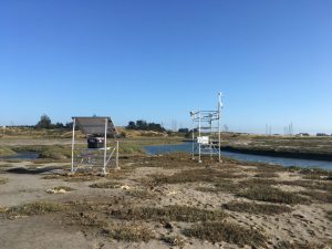
US-EKH: Elkhorn Slough Hester Marsh
- Overview
- Windroses
- Data Citation
- Data Use Log
- Image Gallery
- Remote Sensing Data
- MODIS
- PhenoCam
- GeoNEX
- Publications
- BADM
MODIS NDVI
The time series shows the 16-day Normalized Difference Vegetation Index (NDVI) average from the MOD13Q1 data product.
Use the slider below the time series to zoom in and out.
To view / download these data and other MOD13Q1 products for this site, visit MODIS/Terra Vegetation Indices.
For other related products, visit MODIS/VIIRS Fixed Sites Subsets Tool.
Citation:
ORNL DAAC. 2018. Terrestrial Ecology Subsetting & Visualization Services (TESViS) Fixed Sites Subsets. ORNL DAAC, Oak Ridge, Tennessee, USA. https://doi.org/10.3334/ORNLDAAC/1567
MODIS NDVI subsetted data is not yet available for this site.
For a complete list of AmeriFlux sites, visit ORNL DAAC's MODIS/VIIRS Fixed Sites Subsets Tool.
PhenoCam Images and Derived Time Series Data
PhenoCams are high-resolution digital cameras that take repeated images of studied ecosystems and provide quantitative information about the canopy phenology. The PhenoCam Network coordinates the camera installation and data reporting/analyses across sites in the Americas, providing automated, near-surface remote sensing of canopy phenology across a range of ecosystems and climate zones. Use of PhenoCam images / data should follow the PhenoCam Data Use Policy .
No PhenoCam data for this siteGeoNEX Data Products
GeoNEX led by NASA Earth eXchange (NEX) is a collaborative effort for generating Earth monitoring products from the new generation of geostationary satellite sensors. GeoNEX has produced a suite of geostationary data products including surface reflectance, land surface temperature, surface solar radiation, and many others.
The GeoNEX Common Grid locates GeoNEX data in the geographic (latitude/longitude) projection. Pixels (grid cells) are created at regular 0.005°, 0.01°, and 0.02° resolutions.
GeoNEX pixels below cover the area 0.06° x 0.06° around and including site US-EKH, 36.8094, -121.7523.
Click a square in the grid at left to display its data below.
Coordinates for selected GeoNEX Pixel
Lat: 36.8300 Long: -121.7800
US-EKH
Graph controls:
- Zoom: click-drag
- Pan: shift-click-drag
- Restore zoom level: double-click
- Use the slider below the time series to zoom in and out.
All download requests will be logged.
NDVI: Normalized Difference Vegetation Index
Resolution: 0.01° x 0.01° & 10 minutes
Coordinates for pixel: Lat: 36.8300 Long: -121.7800
NIRv Near-Infrared Reflectance of vegetation
Resolution: 0.01° x 0.01° & 10 minutes
Coordinates for pixel: Lat: 36.8300 Long: -121.7800
DSR: Surface downward shortwave radiation
Resolution: 0.01° x 0.01° & Hourly
Coordinates for pixel: Lat: 36.8300 Long: -121.7800
LST: Land Surface Temperature
Resolution: 0.02° x 0.02° & Hourly
Coordinates for pixel: Lat: 36.8200 Long: -121.7800
Citation
This material can be used without obtaining permission from NASA. NASA should be acknowledged as the source of this material.
Subset Data Citation:
- Hashimoto, H., Wang, W., Park, T., Khajehei, S., Ichii, K., Michaelis, A.R., Guzman, A., Nemani, R.R., Torn, M., Yi, K., Brosnan, I.G. (in preparation). Subsets of geostationary satellite data over international observing network sites for studying the diurnal dynamics of energy, carbon, and water cycles.
Relevant Science Publication Citation:
GeoNEX Surface Reflectance for Vegetation Indices (NDVI & NIRv)- Wang, W., Wang, Y., Lyapustin, A., Hashimoto, H., Park, T., Michaelis, A., & Nemani, R. (2022). A novel atmospheric correction algorithm to exploit the diurnal variability in hypertemporal geostationary observations. Remote Sensing, 14(4), 964.
- Li, R., Wang, D., Wang, W., & Nemani, R. (2023). A GeoNEX-based high-spatiotemporal-resolution product of land surface downward shortwave radiation and photosynthetically active radiation. Earth System Science Data, 15(3), 1419-1436.
- Jia, A., Liang, S., & Wang, D. (2022). Generating a 2-km, all-sky, hourly land surface temperature product from Advanced Baseline Imager data. Remote Sensing of Environment, 278, 113105.
US-EKH: Elkhorn Slough Hester Marsh
- Overview
- Windroses
- Data Citation
- Data Use Log
- Image Gallery
- Remote Sensing Data
- MODIS
- PhenoCam
- GeoNEX
- Publications
- BADM
AmeriFlux Publications | Add Publication |
US-EKH: Elkhorn Slough Hester Marsh
- Overview
- Windroses
- Data Citation
- Data Use Log
- Image Gallery
- Remote Sensing Data
- MODIS
- PhenoCam
- GeoNEX
- Publications
- BADM
BADM for This Site
Access the Biological, Ancillary, Disturbance and Metadata (BADM) information and data for this site.
BADM contain information for many uses, such as characterizing a site’s vegetation and soil, describing disturbance history, and defining instrumentation for flux processing. They complement the flux/met data.
- Download BADM for this site*
- View Site General Info for this site (Overview tab)*
- Use Online Editor to update Site General Info or DOI Authorship
- Update information about submitted data (Variable Information tool)
- More BADM resources
* Online updates are shown on the Overview tab real time. However, downloaded BADM files will not reflect those updates until they have been reviewed for QA/QC.
US-EKH: Elkhorn Slough Hester Marsh
- Overview
- Windroses
- Data Citation
- Data Use Log
- Image Gallery
- Remote Sensing Data
- MODIS
- PhenoCam
- GeoNEX
- Publications
- BADM