
US-DUF: Denver Urban Field Station
- Overview
- Windroses
- Data Citation
- Data Use Log
- Image Gallery
- Remote Sensing Data
- MODIS
- PhenoCam
- GeoNEX
- Publications
- BADM
| Tower_team: | |
| PI: | George Valentine george.valentine@usda.gov - US Forest Service, Rocky Mountain Research Station |
| PI: | John Frank john.frank@usda.gov - US Forest Service, Rocky Mountain Research Station |
| PI: | Travis Warziniack travis.warziniack@usda.gov - US Forest Service, Rocky Mountain Research Station |
| Lat, Long: | 40.5678, -105.0809 |
| Elevation(m): | 1527 |
| Network Affiliations: | AmeriFlux |
| Vegetation IGBP: | URB (Urban and Built-Up Lands: Land covered by buildings and other man-made structures.) |
| Climate Koeppen: | Bsk (Steppe: warm winter) |
| Mean Annual Temp (°C): | 10.4 |
| Mean Annual Precip. (mm): | 402 |
| Flux Species Measured: | CO2, H2O, CH4 |
| Years Data Collected: | 2024 - Present |
| Years Data Available: | AmeriFlux BASE 2024 - 2025 Data Citation |
| Data Use Policy: | AmeriFlux CC-BY-4.0 Policy1 |
| Description: | |
| URL: | — |
| Research Topics: | CO2, H2O, and methane fluxes |
| Acknowledgment: | — |
- This site’s data can also be used under the more restrictive AmeriFlux Legacy Policy.
The AmeriFlux Legacy Policy must be followed if this site’s data are combined with data from sites that require the AmeriFlux Legacy Policy.
Copyright preference: As long as credit is given
US-DUF: Denver Urban Field Station
- Overview
- Windroses
- Data Citation
- Data Use Log
- Image Gallery
- Remote Sensing Data
- MODIS
- PhenoCam
- GeoNEX
- Publications
- BADM
Use the information below for citation of this site. See the Data Policy page for more details.
DOI(s) for citing US-DUF data
Data Use Policy: AmeriFlux CC-BY-4.0 License
This site’s data can also be used under the more restrictive AmeriFlux Legacy Policy.
The AmeriFlux Legacy Policy must be followed if US-DUF data are combined with data from sites that require the AmeriFlux Legacy Policy.
- AmeriFlux BASE: https://doi.org/10.17190/AMF/2567981
Citation: John Frank, George Valentine, Travis Warziniack (2025), AmeriFlux BASE US-DUF Denver Urban Field Station, Ver. 1-5, AmeriFlux AMP, (Dataset). https://doi.org/10.17190/AMF/2567981
To cite BADM when downloaded on their own, use the publications below for citing site characterization. When using BADM that are downloaded with AmeriFlux BASE and AmeriFlux FLUXNET products, use the DOI citation for the associated data product.
Publication(s) for citing site characterization
- —
Acknowledgments
- —
Resources
- AmeriFlux Logos & Acknowledgments
US-DUF: Denver Urban Field Station
- Overview
- Windroses
- Data Citation
- Data Use Log
- Image Gallery
- Remote Sensing Data
- MODIS
- PhenoCam
- GeoNEX
- Publications
- BADM

This page displays the list of downloads of data for the site {{siteId}}.
Note: Results are the number of downloads to distinct data users. The Download Count column indicates the number of times the data user downloaded the data. The Version column refers to the version of the data product for the site that was downloaded by the data user.
| Date | Name | Data Product | Vers. | Intended Use | Intended Use Description | Download Count |
|---|---|---|---|---|---|---|
| {{dlObject.timeStamp}} | {{dlObject.displayName}} | {{displayProduct(dlObject.dataProduct)}} | {{dlObject.version}} | {{dlObject.intendedUse}} | {{dlObject.comment}} | {{dlObject.downloadCounter}} |
Showing {{startItem + 1}} to {{(startItem + items) > filtered.length ? filtered.length : (startItem + items)}} of {{filtered.length}} results
Showing 0 to 0 of 0 results
Not Found
Uh Oh. Something is missing. Try double checking the URL and try again.
US-DUF: Denver Urban Field Station
- Overview
- Windroses
- Data Citation
- Data Use Log
- Image Gallery
- Remote Sensing Data
- MODIS
- PhenoCam
- GeoNEX
- Publications
- BADM
| AmeriFlux Images | Add Image |
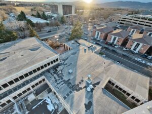 US-DUF
 US-DUF looking southwest
Keywords: —
Location: Colorado, United States
View in Original Size
To download, right-click photo (Mac: control-click) and choose Save Image As
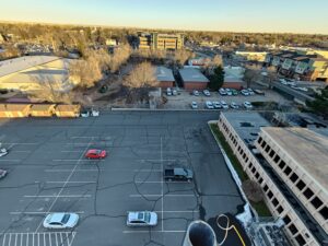 US-DUF
 US-DUF looking east
Keywords: —
Location: United States
View in Original Size
To download, right-click photo (Mac: control-click) and choose Save Image As
 US-DUF
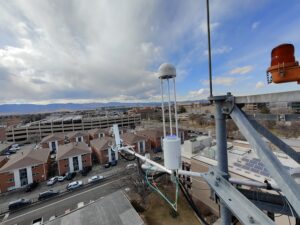
 US-DUF looking north
Vane anemometer in foreground
Keywords: —
Location: United States
View in Original Size
To download, right-click photo (Mac: control-click) and choose Save Image As
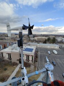
US-DUF US-DUF looking west
CSAT3B, LI-7200RS, and LI-7700 in foreground
Keywords: —
Location: Colorado, United States
View in Original Size
To download, right-click photo (Mac: control-click) and choose Save Image As
US-DUF: Denver Urban Field Station
- Overview
- Windroses
- Data Citation
- Data Use Log
- Image Gallery
- Remote Sensing Data
- MODIS
- PhenoCam
- GeoNEX
- Publications
- BADM
| AmeriFlux Publications | Add Publication |
US-DUF: Denver Urban Field Station
- Overview
- Windroses
- Data Citation
- Data Use Log
- Image Gallery
- Remote Sensing Data
- MODIS
- PhenoCam
- GeoNEX
- Publications
- BADM
BADM for This Site
Access the Biological, Ancillary, Disturbance and Metadata (BADM) information and data for this site.
BADM contain information for many uses, such as characterizing a site’s vegetation and soil, describing disturbance history, and defining instrumentation for flux processing. They complement the flux/met data.
- Download BADM for this site*
- View Site General Info for this site (Overview tab)*
- Use Online Editor to update Site General Info or DOI Authorship
- Update information about submitted data (Variable Information tool)
- More BADM resources
* Online updates are shown on the Overview tab real time. However, downloaded BADM files will not reflect those updates until they have been reviewed for QA/QC.
US-DUF: Denver Urban Field Station
- Overview
- Windroses
- Data Citation
- Data Use Log
- Image Gallery
- Remote Sensing Data
- MODIS
- PhenoCam
- GeoNEX
- Publications
- BADM