
US-BFS: Robert J. Bernard Biological Field Station
- Overview
- Windroses
- Data Citation
- Data Use Log
- Image Gallery
- Remote Sensing Data
- MODIS
- PhenoCam
- GeoNEX
- Publications
- BADM
| Tower_team: | |
| PI: | Sarah Kavassalis skavassalis@g.hmc.edu - Harvey Mudd College |
| Lat, Long: | 34.1131, -117.7118 |
| Elevation(m): | 410 |
| Network Affiliations: | AmeriFlux |
| Vegetation IGBP: | OSH (Open Shrublands: Lands with woody vegetation less than 2 meters tall and with shrub canopy cover between 10-60%. The shrub foliage can be either evergreen or deciduous.) |
| Climate Koeppen: | Csa (Mediterranean: mild with dry, hot summer) |
| Mean Annual Temp (°C): | 17.22 |
| Mean Annual Precip. (mm): | 343 |
| Flux Species Measured: | CO2, H, H2O |
| Years Data Collected: | 2024 - Present |
| Years Data Available: | AmeriFlux BASE 2025 Data Citation |
| Data Use Policy: | AmeriFlux Legacy Policy |
| Description: | |
| URL: | https://www.ficus.space/bfs |
| Research Topics: | |
| Acknowledgment: | — |

Copyright preference: Request for permission
US-BFS: Robert J. Bernard Biological Field Station
- Overview
- Windroses
- Data Citation
- Data Use Log
- Image Gallery
- Remote Sensing Data
- MODIS
- PhenoCam
- GeoNEX
- Publications
- BADM
Use the information below for citation of this site. See the Data Policy page for more details.
DOI(s) for citing US-BFS data
Data Use Policy: AmeriFlux Legacy Policy
- AmeriFlux BASE: https://doi.org/10.17190/AMF/3004319
Citation: Sarah Kavassalis (2025), AmeriFlux BASE US-BFS Robert J. Bernard Biological Field Station, Ver. 1-5, AmeriFlux AMP, (Dataset). https://doi.org/10.17190/AMF/3004319
To cite BADM when downloaded on their own, use the publications below for citing site characterization. When using BADM that are downloaded with AmeriFlux BASE and AmeriFlux FLUXNET products, use the DOI citation for the associated data product.
Publication(s) for citing site characterization
- —
Acknowledgments
- —
Resources
- AmeriFlux Logos & Acknowledgments
US-BFS: Robert J. Bernard Biological Field Station
- Overview
- Windroses
- Data Citation
- Data Use Log
- Image Gallery
- Remote Sensing Data
- MODIS
- PhenoCam
- GeoNEX
- Publications
- BADM

This page displays the list of downloads of data for the site {{siteId}}.
Note: Results are the number of downloads to distinct data users. The Download Count column indicates the number of times the data user downloaded the data. The Version column refers to the version of the data product for the site that was downloaded by the data user.
| Date | Name | Data Product | Vers. | Intended Use | Intended Use Description | Download Count |
|---|---|---|---|---|---|---|
| {{dlObject.timeStamp}} | {{dlObject.displayName}} | {{displayProduct(dlObject.dataProduct)}} | {{dlObject.version}} | {{dlObject.intendedUse}} | {{dlObject.comment}} | {{dlObject.downloadCounter}} |
Showing {{startItem + 1}} to {{(startItem + items) > filtered.length ? filtered.length : (startItem + items)}} of {{filtered.length}} results
Showing 0 to 0 of 0 results
Not Found
Uh Oh. Something is missing. Try double checking the URL and try again.
US-BFS: Robert J. Bernard Biological Field Station
- Overview
- Windroses
- Data Citation
- Data Use Log
- Image Gallery
- Remote Sensing Data
- MODIS
- PhenoCam
- GeoNEX
- Publications
- BADM
| AmeriFlux Images | Add Image |
US-BFS US-BFS up close
US-BFS tripod closer up (sage scrub viewable, a rare cloudy day)
Keywords: sage scrub, Artemisia, tripod
Location: California, United States
View in Original Size
To download, right-click photo (Mac: control-click) and choose Save Image As
 US-BFS
 US-BFS Current Location
US-BFS tripod surrounded by southern coastal sage scrub (mostly Artemisia californica)
Keywords: sage scrub, Artemisia, tripod
Location: California, United States
View in Original Size
To download, right-click photo (Mac: control-click) and choose Save Image As
 US-BFS
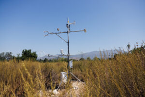
 Tripod in the sage scrub
Photo of our flux tripod surrounded by the sage scrub vegetation.
Keywords: Tripod, IRGASON, csat, sage scrub, dry lands, California
Location: California, United States
View in Original Size
To download, right-click photo (Mac: control-click) and choose Save Image As
US-BFS: Robert J. Bernard Biological Field Station
- Overview
- Windroses
- Data Citation
- Data Use Log
- Image Gallery
- Remote Sensing Data
- MODIS
- PhenoCam
- GeoNEX
- Publications
- BADM
| AmeriFlux Publications | Add Publication |
US-BFS: Robert J. Bernard Biological Field Station
- Overview
- Windroses
- Data Citation
- Data Use Log
- Image Gallery
- Remote Sensing Data
- MODIS
- PhenoCam
- GeoNEX
- Publications
- BADM
BADM for This Site
Access the Biological, Ancillary, Disturbance and Metadata (BADM) information and data for this site.
BADM contain information for many uses, such as characterizing a site’s vegetation and soil, describing disturbance history, and defining instrumentation for flux processing. They complement the flux/met data.
- Download BADM for this site*
- View Site General Info for this site (Overview tab)*
- Use Online Editor to update Site General Info or DOI Authorship
- Update information about submitted data (Variable Information tool)
- More BADM resources
* Online updates are shown on the Overview tab real time. However, downloaded BADM files will not reflect those updates until they have been reviewed for QA/QC.
US-BFS: Robert J. Bernard Biological Field Station
- Overview
- Windroses
- Data Citation
- Data Use Log
- Image Gallery
- Remote Sensing Data
- MODIS
- PhenoCam
- GeoNEX
- Publications
- BADM