
MX-PMm: Puerto Morelos mangrove
- Overview
- Windroses
- Data Citation
- Data Use Log
- Image Gallery
- Remote Sensing Data
- MODIS
- PhenoCam
- GeoNEX
- Publications
- BADM
| Tower_team: | |
| PI: | Susana Alvarado-Barrientos susana.alvarado@gmail.com - Instituto de Ecología A.C. |
| Lat, Long: | 20.8462, -86.8992 |
| Elevation(m): | 10 |
| Network Affiliations: | AmeriFlux, MexFlux |
| Vegetation IGBP: | WET (Permanent Wetlands: Lands with a permanent mixture of water and herbaceous or woody vegetation that cover extensive areas. The vegetation can be present in either salt, brackish, or fresh water) |
| Climate Koeppen: | Aw (Tropical savanna) |
| Mean Annual Temp (°C): | 26.2 |
| Mean Annual Precip. (mm): | 1222 |
| Flux Species Measured: | CO2, H, H2O |
| Years Data Collected: | 2017 - 2018 |
| Years Data Available: | AmeriFlux BASE 2017 - 2018 Data Citation AmeriFlux FLUXNET 2017 - 2018 Data Citation |
| Data Use Policy: | AmeriFlux CC-BY-4.0 Policy1 |
| Description: | |
| URL: | — |
| Research Topics: | |
| Acknowledgment: | CONACyT is acknowledged for providing all funds (INFR-2016-01 N° 269269 to SAB) for the infrastructure related to flux measurements. El Colegio de la Frontera Sur is acknowledged for providing funds for site operation and maintenance. |
- This site’s data can also be used under the more restrictive AmeriFlux Legacy Policy.
The AmeriFlux Legacy Policy must be followed if this site’s data are combined with data from sites that require the AmeriFlux Legacy Policy.
Copyright preference: Request for permission
MX-PMm: Puerto Morelos mangrove
- Overview
- Windroses
- Data Citation
- Data Use Log
- Image Gallery
- Remote Sensing Data
- MODIS
- PhenoCam
- GeoNEX
- Publications
- BADM
Use the information below for citation of this site. See the Data Policy page for more details.
DOI(s) for citing MX-PMm data
Data Use Policy: AmeriFlux CC-BY-4.0 License
This site’s data can also be used under the more restrictive AmeriFlux Legacy Policy.
The AmeriFlux Legacy Policy must be followed if MX-PMm data are combined with data from sites that require the AmeriFlux Legacy Policy.
- AmeriFlux BASE: https://doi.org/10.17190/AMF/1756415
Citation: Ma. Susana Alvarado-Barrientos (2021), AmeriFlux BASE MX-PMm Puerto Morelos mangrove, Ver. 2-5, AmeriFlux AMP, (Dataset). https://doi.org/10.17190/AMF/1756415 - AmeriFlux FLUXNET: https://doi.org/10.17190/AMF/3027673
Citation: Ma. Susana Alvarado-Barrientos (2026), AmeriFlux FLUXNET-1F MX-PMm Puerto Morelos mangrove, Ver. v1.3_r1, AmeriFlux AMP, (Dataset). https://doi.org/10.17190/AMF/3027673
Find global FLUXNET datasets, like FLUXNET2015 and FLUXNET-CH4, and their citation information at fluxnet.org.
To cite BADM when downloaded on their own, use the publications below for citing site characterization. When using BADM that are downloaded with AmeriFlux BASE and AmeriFlux FLUXNET products, use the DOI citation for the associated data product.
Publication(s) for citing site characterization
- —
Acknowledgments
- —
Resources
- AmeriFlux Logos & Acknowledgments
MX-PMm: Puerto Morelos mangrove
- Overview
- Windroses
- Data Citation
- Data Use Log
- Image Gallery
- Remote Sensing Data
- MODIS
- PhenoCam
- GeoNEX
- Publications
- BADM

This page displays the list of downloads of data for the site {{siteId}}.
Note: Results are the number of downloads to distinct data users. The Download Count column indicates the number of times the data user downloaded the data. The Version column refers to the version of the data product for the site that was downloaded by the data user.
| Date | Name | Data Product | Vers. | Intended Use | Intended Use Description | Download Count |
|---|---|---|---|---|---|---|
| {{dlObject.timeStamp}} | {{dlObject.displayName}} | {{displayProduct(dlObject.dataProduct)}} | {{dlObject.version}} | {{dlObject.intendedUse}} | {{dlObject.comment}} | {{dlObject.downloadCounter}} |
Showing {{startItem + 1}} to {{(startItem + items) > filtered.length ? filtered.length : (startItem + items)}} of {{filtered.length}} results
Showing 0 to 0 of 0 results
Not Found
Uh Oh. Something is missing. Try double checking the URL and try again.
MX-PMm: Puerto Morelos mangrove
- Overview
- Windroses
- Data Citation
- Data Use Log
- Image Gallery
- Remote Sensing Data
- MODIS
- PhenoCam
- GeoNEX
- Publications
- BADM
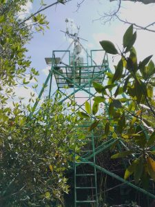
| AmeriFlux Images | Add Image |
MX-PMm Flux tower from the walkway
Flux tower from the walkway
Keywords: basin mangrove, flux tower
Location: Mexico
View in Original Size
To download, right-click photo (Mac: control-click) and choose Save Image As
MX-PMm: Puerto Morelos mangrove
- Overview
- Windroses
- Data Citation
- Data Use Log
- Image Gallery
- Remote Sensing Data
- MODIS
- PhenoCam
- GeoNEX
- Publications
- BADM
| AmeriFlux Publications | Add Publication |
| Year | Publication |
|---|---|
| 2021 | Alvarado‐Barrientos, M. S., López‐Adame, H., Lazcano‐Hernández, H. E., Arellano‐Verdejo, J., Hernández‐Arana, H. A. (2021) Ecosystem‐Atmosphere Exchange Of CO2, Water, And Energy In A Basin Mangrove Of The Northeastern Coast Of The Yucatan Peninsula, Journal Of Geophysical Research: Biogeosciences, 126(2), e2020JG005811. https://doi.org/https://doi.org/10.1029/2020JG005811 |
| 2020 | Alvarado‐Barrientos, M. S., López‐Adame, H., Lazcano‐Hernández, H. E., Arellano‐Verdejo, J., Hernández‐Arana, H. A. (2020) Ecosystem‐Atmosphere Exchange Of CO2, Water And Energy In A Basin Mangrove Of The Northeastern Coast Of The Yucatan Peninsula, Journal Of Geophysical Research: Biogeosciences, 125, . https://doi.org/https://doi.org/10.1029/2020JG005811 |
MX-PMm: Puerto Morelos mangrove
- Overview
- Windroses
- Data Citation
- Data Use Log
- Image Gallery
- Remote Sensing Data
- MODIS
- PhenoCam
- GeoNEX
- Publications
- BADM
BADM for This Site
Access the Biological, Ancillary, Disturbance and Metadata (BADM) information and data for this site.
BADM contain information for many uses, such as characterizing a site’s vegetation and soil, describing disturbance history, and defining instrumentation for flux processing. They complement the flux/met data.
- Download BADM for this site*
- View Site General Info for this site (Overview tab)*
- Use Online Editor to update Site General Info or DOI Authorship
- Update information about submitted data (Variable Information tool)
- More BADM resources
* Online updates are shown on the Overview tab real time. However, downloaded BADM files will not reflect those updates until they have been reviewed for QA/QC.
MX-PMm: Puerto Morelos mangrove
- Overview
- Windroses
- Data Citation
- Data Use Log
- Image Gallery
- Remote Sensing Data
- MODIS
- PhenoCam
- GeoNEX
- Publications
- BADM
Wind Roses
Wind Speed (m/s)
- Wind Speed Scale: Per Site
- Wind Direction Scale (%): Per Site
- Wind Speed Scale: Non-Linear
- Wind Direction Scale (%): AmeriFlux