
CA-SF3: Saskatchewan - Western Boreal, forest burned in 1998
- Overview
- Windroses
- Data Citation
- Data Use Log
- Image Gallery
- Remote Sensing Data
- MODIS
- PhenoCam
- GeoNEX
- Publications
- BADM
| Tower_team: | |
| PI: | Brian Amiro Brian_Amiro@umanitoba.ca - University of Manitoba; Canadian Forest Service |
| Lat, Long: | 54.0916, -106.0053 |
| Elevation(m): | 540 |
| Network Affiliations: | AmeriFlux, Fluxnet-Canada |
| Vegetation IGBP: | OSH (Open Shrublands: Lands with woody vegetation less than 2 meters tall and with shrub canopy cover between 10-60%. The shrub foliage can be either evergreen or deciduous.) |
| Climate Koeppen: | Dfc (Subarctic: severe winter, no dry season, cool summer) |
| Mean Annual Temp (°C): | 0.4 |
| Mean Annual Precip. (mm): | 470 |
| Flux Species Measured: | CO2 |
| Years Data Collected: | 2001 - 2006 |
| Years Data Available: | AmeriFlux BASE 2001 - 2006 Data Citation AmeriFlux FLUXNET 2001 - 2006 Data Citation |
| Data Use Policy: | AmeriFlux CC-BY-4.0 Policy1 |
| Description: | |
| URL: | — |
| Research Topics: | — |
| Acknowledgment: | The data collection was funded by the Canadian Forest Service (Natural Resources Canada) and by Parks Canada as part of the BERMS (Boreal Ecosystem Research and Monitoring Sites) initiative in collaboration with the Fluxnet Canada Research Network and the Canadian Carbon Program (supported by the Canadian National Science and Engineering Research Council (NSERC), the Canadian Foundation for Climate and Atmospheric Sciences and the BIOCAP Canada Foundation). |
- This site’s data can also be used under the more restrictive AmeriFlux Legacy Policy.
The AmeriFlux Legacy Policy must be followed if this site’s data are combined with data from sites that require the AmeriFlux Legacy Policy.
Copyright preference: Open use
CA-SF3: Saskatchewan - Western Boreal, forest burned in 1998
- Overview
- Windroses
- Data Citation
- Data Use Log
- Image Gallery
- Remote Sensing Data
- MODIS
- PhenoCam
- GeoNEX
- Publications
- BADM
Use the information below for citation of this site. See the Data Policy page for more details.
DOI(s) for citing CA-SF3 data
Data Use Policy: AmeriFlux CC-BY-4.0 License
This site’s data can also be used under the more restrictive AmeriFlux Legacy Policy.
The AmeriFlux Legacy Policy must be followed if CA-SF3 data are combined with data from sites that require the AmeriFlux Legacy Policy.
- AmeriFlux BASE: https://doi.org/10.17190/AMF/1246008
Citation: Brian Amiro (2020), AmeriFlux BASE CA-SF3 Saskatchewan - Western Boreal, forest burned in 1998, Ver. 2-5, AmeriFlux AMP, (Dataset). https://doi.org/10.17190/AMF/1246008 - AmeriFlux FLUXNET: https://doi.org/10.17190/AMF/3027313
Citation: Brian Amiro (2026), AmeriFlux FLUXNET-1F CA-SF3 Saskatchewan - Western Boreal, forest burned in 1998, Ver. v1.3_r1, AmeriFlux AMP, (Dataset). https://doi.org/10.17190/AMF/3027313
Find global FLUXNET datasets, like FLUXNET2015 and FLUXNET-CH4, and their citation information at fluxnet.org.
To cite BADM when downloaded on their own, use the publications below for citing site characterization. When using BADM that are downloaded with AmeriFlux BASE and AmeriFlux FLUXNET products, use the DOI citation for the associated data product.
Publication(s) for citing site characterization
- —
Acknowledgments
- —
Resources
- AmeriFlux Logos & Acknowledgments
CA-SF3: Saskatchewan - Western Boreal, forest burned in 1998
- Overview
- Windroses
- Data Citation
- Data Use Log
- Image Gallery
- Remote Sensing Data
- MODIS
- PhenoCam
- GeoNEX
- Publications
- BADM

This page displays the list of downloads of data for the site {{siteId}}.
Note: Results are the number of downloads to distinct data users. The Download Count column indicates the number of times the data user downloaded the data. The Version column refers to the version of the data product for the site that was downloaded by the data user.
| Date | Name | Data Product | Vers. | Intended Use | Intended Use Description | Download Count |
|---|---|---|---|---|---|---|
| {{dlObject.timeStamp}} | {{dlObject.displayName}} | {{displayProduct(dlObject.dataProduct)}} | {{dlObject.version}} | {{dlObject.intendedUse}} | {{dlObject.comment}} | {{dlObject.downloadCounter}} |
Showing {{startItem + 1}} to {{(startItem + items) > filtered.length ? filtered.length : (startItem + items)}} of {{filtered.length}} results
Showing 0 to 0 of 0 results
Not Found
Uh Oh. Something is missing. Try double checking the URL and try again.
CA-SF3: Saskatchewan - Western Boreal, forest burned in 1998
- Overview
- Windroses
- Data Citation
- Data Use Log
- Image Gallery
- Remote Sensing Data
- MODIS
- PhenoCam
- GeoNEX
- Publications
- BADM
| AmeriFlux Images | Add Image |
 CA-SF3
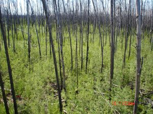
 CA-SF3 regrowth
Regrowth after fire at CA-SF3
Keywords: boreal forest,fire
Location: Saskatchewan, Canada
View in Original Size
To download, right-click photo (Mac: control-click) and choose Save Image As
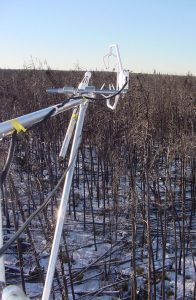
CA-SF3 CA-SF3 winter from tower
Winter looking down from tower at CA-SF3
Keywords: boreal forest,fire
Location: Saskatchewan, Canada
View in Original Size
To download, right-click photo (Mac: control-click) and choose Save Image As
 CA-SF3
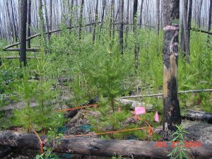
 CA-SF3 understorey
Understorey at CA-SF3
Keywords: boreal forest,fire
Location: Saskatchewan, Canada
View in Original Size
To download, right-click photo (Mac: control-click) and choose Save Image As
 CA-SF3
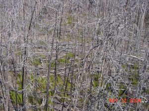
 CA-SF3 looking down
Looking down from tower at CA-SF3
Keywords: boreal forest,fire
Location: Saskatchewan, Canada
View in Original Size
To download, right-click photo (Mac: control-click) and choose Save Image As
CA-SF3: Saskatchewan - Western Boreal, forest burned in 1998
- Overview
- Windroses
- Data Citation
- Data Use Log
- Image Gallery
- Remote Sensing Data
- MODIS
- PhenoCam
- GeoNEX
- Publications
- BADM
| AmeriFlux Publications | Add Publication |
| Year | Publication |
|---|---|
| 2021 | Chu, H., Luo, X., Ouyang, Z., Chan, W. S., Dengel, S., Biraud, S. C., Torn, M. S., Metzger, S., Kumar, J., Arain, M. A., Arkebauer, T. J., Baldocchi, D., Bernacchi, C., Billesbach, D., Black, T. A., Blanken, P. D., Bohrer, G., Bracho, R., Brown, S., Brunsell, N. A., Chen, J., Chen, X., Clark, K., Desai, A. R., Duman, T., Durden, D., Fares, S., Forbrich, I., Gamon, J. A., Gough, C. M., Griffis, T., Helbig, M., Hollinger, D., Humphreys, E., Ikawa, H., Iwata, H., Ju, Y., Knowles, J. F., Knox, S. H., Kobayashi, H., Kolb, T., Law, B., Lee, X., Litvak, M., Liu, H., Munger, J. W., Noormets, A., Novick, K., Oberbauer, S. F., Oechel, W., Oikawa, P., Papuga, S. A., Pendall, E., Prajapati, P., Prueger, J., Quinton, W. L., Richardson, A. D., Russell, E. S., Scott, R. L., Starr, G., Staebler, R., Stoy, P. C., Stuart-Haëntjens, E., Sonnentag, O., Sullivan, R. C., Suyker, A., Ueyama, M., Vargas, R., Wood, J. D., Zona, D. (2021) Representativeness Of Eddy-Covariance Flux Footprints For Areas Surrounding Ameriflux Sites, Agricultural And Forest Meteorology, 301-302, 108350. https://doi.org/10.1016/j.agrformet.2021.108350 |
| 2018 | Baldocchi, D., Penuelas, J. (2018) The Physics And Ecology Of Mining Carbon Dioxide From The Atmosphere By Ecosystems, Global Change Biology, . https://doi.org/10.1111/gcb.14559 |
| 2009 | Amiro, B. (2009) Measuring Boreal Forest Evapotranspiration Using The Energy Balance Residual, Journal Of Hydrology, 366(1-4), 112-118. https://doi.org/10.1016/j.jhydrol.2008.12.021 |
| 2006 | Amiro, B., Orchansky, A., Barr, A., Black, T., Chambers, S., Chapin III, F., Goulden, M., Litvak, M., Liu, H., McCaughey, J., McMillan, A., Randerson, J. (2006) The Effect Of Post-Fire Stand Age On The Boreal Forest Energy Balance, Agricultural And Forest Meteorology, 140(1-4), 41-50. https://doi.org/10.1016/j.agrformet.2006.02.014 |
| 2010 | Amiro, B.D., Barr, A.G., Barr, J.G., Black, T.A., Bracho, R., Brown, M., Chen, J., Clark, K.L., Davis, K.J., Desai, A.R., Dore, S., Engel, V., Fuentes, J.D., Goldstein, A.H., Goulden, M.L., Kolb, T.E., Lavigne, M.B., Law, B.E., Margolis, H.A., Martin, T., McCaughey, J.H., Misson, L., Montes-Helu, M., Noormets, A., Randerson, J.T., Starr, G., Xiao, J. (2010) Ecosystem Carbon Dioxide Fluxes After Disturbance In Forests Of North America, Journal Of Geophysical Research, 115(G00K02), n/a-n/a. https://doi.org/10.1029/2010jg001390 |
| 2001 | Amiro, B. D. (2001) Paired-Tower Measurements Of Carbon And Energy Fluxes Following Disturbance In The Boreal Forest, Global Change Biology, 7(3), 253-268. https://doi.org/10.1046/j.1365-2486.2001.00398.x |
| 1999 | Rayment, M. B., Jarvis, P. G. (1999) Seasonal Gas Exchange Of Black Spruce Using An Automatic Branch Bag System, Canadian Journal Of Forest Research, 29(10), 1528-1538. https://doi.org/10.1139/cjfr-29-10-1528 |
| 2003 | Amiro, B. D., Ian MacPherson, J., Desjardins, R. L., Chen, J. M., Liu, J. (2003) Post-Fire Carbon Dioxide Fluxes In The Western Canadian Boreal Forest: Evidence From Towers, Aircraft And Remote Sensing, Agricultural And Forest Meteorology, 115(1-2), 91-107. https://doi.org/10.1016/s0168-1923(02)00170-3 |
| 2009 | Mkhabela, M., Amiro, B., Barr, A., Black, T., Hawthorne, I., Kidston, J., McCaughey, J., Orchansky, A., Nesic, Z., Sass, A., Shashkov, A., Zha, T. (2009) Comparison Of Carbon Dynamics And Water Use Efficiency Following Fire And Harvesting In Canadian Boreal Forests, Agricultural And Forest Meteorology, 149(5), 783-794. https://doi.org/10.1016/j.agrformet.2008.10.025 |
| 2006 | Amiro, B., Barr, A., Black, T., Iwashita, H., Kljun, N., Mccaughey, J., Morgenstern, K., Murayama, S., Nesic, Z., Orchansky, A. (2006) Carbon, Energy And Water Fluxes At Mature And Disturbed Forest Sites, Saskatchewan, Canada, Agricultural And Forest Meteorology, 136(3-4), 237-251. https://doi.org/10.1016/j.agrformet.2004.11.012 |
| 2010 | Amiro, B. (2010) Estimating Annual Carbon Dioxide Eddy Fluxes Using Open-Path Analysers For Cold Forest Sites, Agricultural And Forest Meteorology, 150(10), 1366-1372. https://doi.org/10.1016/j.agrformet.2010.06.007 |
CA-SF3: Saskatchewan - Western Boreal, forest burned in 1998
- Overview
- Windroses
- Data Citation
- Data Use Log
- Image Gallery
- Remote Sensing Data
- MODIS
- PhenoCam
- GeoNEX
- Publications
- BADM
BADM for This Site
Access the Biological, Ancillary, Disturbance and Metadata (BADM) information and data for this site.
BADM contain information for many uses, such as characterizing a site’s vegetation and soil, describing disturbance history, and defining instrumentation for flux processing. They complement the flux/met data.
- Download BADM for this site*
- View Site General Info for this site (Overview tab)*
- Use Online Editor to update Site General Info or DOI Authorship
- Update information about submitted data (Variable Information tool)
- More BADM resources
* Online updates are shown on the Overview tab real time. However, downloaded BADM files will not reflect those updates until they have been reviewed for QA/QC.
CA-SF3: Saskatchewan - Western Boreal, forest burned in 1998
- Overview
- Windroses
- Data Citation
- Data Use Log
- Image Gallery
- Remote Sensing Data
- MODIS
- PhenoCam
- GeoNEX
- Publications
- BADM
Wind Roses
Wind Speed (m/s)
- Wind Speed Scale: Per Site
- Wind Direction Scale (%): Per Site
- Wind Speed Scale: Non-Linear
- Wind Direction Scale (%): AmeriFlux