CA-EM3: Oak Hammock Marsh Manitoba
- Overview
- Windroses
- Data Citation
- Data Use Log
- Image Gallery
- Remote Sensing Data
- MODIS
- PhenoCam
- GeoNEX
- Publications
- BADM
Tower_team: | |
PI: | Pascal Badiou p_badiou@ducks.ca - Institute for Wetland and Waterfowl Research, Ducks Unlimited Canada |
Lat, Long: | 50.1738, -97.1231 |
Elevation(m): | 255 |
Network Affiliations: | AmeriFlux |
Vegetation IGBP: | WET (Permanent Wetlands: Lands with a permanent mixture of water and herbaceous or woody vegetation that cover extensive areas. The vegetation can be present in either salt, brackish, or fresh water) |
Climate Koeppen: | Dfb (Warm Summer Continental: significant precipitation in all seasons ) |
Mean Annual Temp (°C): | 3 |
Mean Annual Precip. (mm): | 521.1 |
Flux Species Measured: | CO2, CH4, H, H2O, N2O |
Years Data Collected: | 2023 - Present |
Years Data Available: | No data available |
Data Use Policy: | AmeriFlux CC-BY-4.0 Policy1 |
Description: | This tower is located in a large restored freshwater marsh located in an intensive agricultural region of south central Manitoba near the town of Stonewall. ... This tower is located in a large restored freshwater marsh located in an intensive agricultural region of south central Manitoba near the town of Stonewall. The tower is situated on a nesting islands in Cell 2 of the Oak Hammock Marsh Complex. The wetland vegetation is dominated cattail with small pockets of open-water interspersed. See MoreShow Less |
URL: | — |
Research Topics: | — |
Acknowledgment: | — |
- This site’s data can also be used under the more restrictive AmeriFlux Legacy Policy.
The AmeriFlux Legacy Policy must be followed if this site’s data are combined with data from sites that require the AmeriFlux Legacy Policy.


Copyright preference: Request for permission
CA-EM3: Oak Hammock Marsh Manitoba
- Overview
- Windroses
- Data Citation
- Data Use Log
- Image Gallery
- Remote Sensing Data
- MODIS
- PhenoCam
- GeoNEX
- Publications
- BADM
Use the information below for citation of this site. See the Data Policy page for more details.
DOI(s) for citing CA-EM3 data
Data Use Policy: AmeriFlux CC-BY-4.0 License
- No DOIs available for CA-EM3
To cite BADM downloaded as a BIF file, use the publications listed below.
Publication(s) for citing site characterization
- —
Acknowledgments
- —
Resources
- AmeriFlux Logos & Acknowledgments
CA-EM3: Oak Hammock Marsh Manitoba
- Overview
- Windroses
- Data Citation
- Data Use Log
- Image Gallery
- Remote Sensing Data
- MODIS
- PhenoCam
- GeoNEX
- Publications
- BADM

This page displays the list of downloads of data for the site CA-EM3.
Note: Results are the number of downloads to distinct data users. The Download Count column indicates the number of times the data user downloaded the data. The Version column refers to the version of the data product for the site that was downloaded by the data user.
Date | Name | Data Product | Version | Intended Use | Intended Use Description | Download Count |
---|
Date | Name | Data Product | Vers. | Intended Use | Intended Use Description | Download Count |
---|---|---|---|---|---|---|
Showing 0 to 0 of 0 results
Not Found
Uh Oh. Something is missing. Try double checking the URL and try again.
CA-EM3: Oak Hammock Marsh Manitoba
- Overview
- Windroses
- Data Citation
- Data Use Log
- Image Gallery
- Remote Sensing Data
- MODIS
- PhenoCam
- GeoNEX
- Publications
- BADM
AmeriFlux Images | Add Image |

CA-EM3
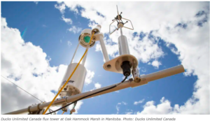
Ducks Unlimited Canada flux tower at Oak Hammock Marsh in Manitoba.
Keywords: CA-EM3
Location: Manitoba, Canada
View in Original Size
To download, right-click photo (Mac: control-click) and choose Save Image As
CA-EM3: Oak Hammock Marsh Manitoba
- Overview
- Windroses
- Data Citation
- Data Use Log
- Image Gallery
- Remote Sensing Data
- MODIS
- PhenoCam
- GeoNEX
- Publications
- BADM
MODIS NDVI
The time series shows the 16-day Normalized Difference Vegetation Index (NDVI) average from the MOD13Q1 data product.
Use the slider below the time series to zoom in and out.
To view / download these data and other MOD13Q1 products for this site, visit MODIS/Terra Vegetation Indices.
For other related products, visit MODIS/VIIRS Fixed Sites Subsets Tool.
Citation:
ORNL DAAC. 2018. Terrestrial Ecology Subsetting & Visualization Services (TESViS) Fixed Sites Subsets. ORNL DAAC, Oak Ridge, Tennessee, USA. https://doi.org/10.3334/ORNLDAAC/1567
MODIS NDVI subsetted data is not yet available for this site.
For a complete list of AmeriFlux sites, visit ORNL DAAC's MODIS/VIIRS Fixed Sites Subsets Tool.
PhenoCam Images and Derived Time Series Data
PhenoCams are high-resolution digital cameras that take repeated images of studied ecosystems and provide quantitative information about the canopy phenology. The PhenoCam Network coordinates the camera installation and data reporting/analyses across sites in the Americas, providing automated, near-surface remote sensing of canopy phenology across a range of ecosystems and climate zones. Use of PhenoCam images / data should follow the PhenoCam Data Use Policy .
PhenoCam sites for CA-EM3:
Use the links below to explore camera images and interactive timeseries for these sites.
Citation:
B. Seyednasrollah, A. M. Young, K. Hufkens, T. Milliman, M. A. Friedl, S. Frolking, and A. D. Richardson. Tracking vegetation phenology across diverse biomes using version 2.0 of the phenocam dataset. Scientific Data, 6(1):222, 2019. doi:10.1038/s41597-019-0229-9Camera Imagery
Milliman, T., B. Seyednasrollah, A.M. Young, K. Hufkens, M.A. Friedl, S. Frolking, A.D. Richardson, M. Abraha, D.W. Allen, M. Apple, M.A. Arain, J.M. Baker, D. Baldocchi, C.J. Bernacchi, J. Bhattacharjee, P. Blanken, D.D. Bosch, R. Boughton, E.H. Boughton, R.F. Brown, D.M. Browning, N. Brunsell, S.P. Burns, M. Cavagna, H. Chu, P.E. Clark, B.J. Conrad, E. Cremonese, D. Debinski, A.R. Desai, R. Diaz-Delgado, L. Duchesne, A.L. Dunn, D.M. Eissenstat, T. El-Madany, D.S.S. Ellum, S.M. Ernest, A. Esposito, L. Fenstermaker, L.B. Flanagan, B. Forsythe, J. Gallagher, D. Gianelle, T. Griffis, P. Groffman, L. Gu, J. Guillemot, M. Halpin, P.J. Hanson, D. Hemming, A.A. Hove, E.R. Humphreys, A. Jaimes-Hernandez, A.A. Jaradat, J. Johnson, E. Keel, V.R. Kelly, J.W. Kirchner, P.B. Kirchner, M. Knapp, M. Krassovski, O. Langvall, G. Lanthier, G.l. Maire, E. Magliulo, T.A. Martin, B. McNeil, G.A. Meyer, M. Migliavacca, B.P. Mohanty, C.E. Moore, R. Mudd, J.W. Munger, Z.E. Murrell, Z. Nesic, H.S. Neufeld, W. Oechel, A.C. Oishi, W.W. Oswald, T.D. Perkins, M.L. Reba, B. Rundquist, B.R. Runkle, E.S. Russell, E.J. Sadler, A. Saha, N.Z. Saliendra, L. Schmalbeck, M.D. Schwartz, R.L. Scott, E.M. Smith, O. Sonnentag, P. Stoy, S. Strachan, K. Suvocarev, J.E. Thom, R.Q. Thomas, A.K. Van den berg, R. Vargas, J. Verfaillie, C.S. Vogel, J.J. Walker, N. Webb, P. Wetzel, S. Weyers, A.V. Whipple, T.G. Whitham, G. Wohlfahrt, J.D. Wood, J. Yang, X. Yang, G. Yenni, Y. Zhang, Q. Zhang, and D. Zona. 2019. PhenoCam Dataset v2.0: Digital Camera Imagery from the PhenoCam Network, 2000-2018. ORNL DAAC, Oak Ridge, Tennessee, USA. https://doi.org/10.3334/ORNLDAAC/1689
Green Chromatic Coordinate Time Series
Seyednasrollah, B., A.M. Young, K. Hufkens, T. Milliman, M.A. Friedl, S. Frolking, A.D. Richardson, M. Abraha, D.W. Allen, M. Apple, M.A. Arain, J. Baker, J.M. Baker, D. Baldocchi, C.J. Bernacchi, J. Bhattacharjee, P. Blanken, D.D. Bosch, R. Boughton, E.H. Boughton, R.F. Brown, D.M. Browning, N. Brunsell, S.P. Burns, M. Cavagna, H. Chu, P.E. Clark, B.J. Conrad, E. Cremonese, D. Debinski, A.R. Desai, R. Diaz-Delgado, L. Duchesne, A.L. Dunn, D.M. Eissenstat, T. El-Madany, D.S.S. Ellum, S.M. Ernest, A. Esposito, L. Fenstermaker, L.B. Flanagan, B. Forsythe, J. Gallagher, D. Gianelle, T. Griffis, P. Groffman, L. Gu, J. Guillemot, M. Halpin, P.J. Hanson, D. Hemming, A.A. Hove, E.R. Humphreys, A. Jaimes-Hernandez, A.A. Jaradat, J. Johnson, E. Keel, V.R. Kelly, J.W. Kirchner, P.B. Kirchner, M. Knapp, M. Krassovski, O. Langvall, G. Lanthier, G.l. Maire, E. Magliulo, T.A. Martin, B. McNeil, G.A. Meyer, M. Migliavacca, B.P. Mohanty, C.E. Moore, R. Mudd, J.W. Munger, Z.E. Murrell, Z. Nesic, H.S. Neufeld, T.L. O'Halloran, W. Oechel, A.C. Oishi, W.W. Oswald, T.D. Perkins, M.L. Reba, B. Rundquist, B.R. Runkle, E.S. Russell, E.J. Sadler, A. Saha, N.Z. Saliendra, L. Schmalbeck, M.D. Schwartz, R.L. Scott, E.M. Smith, O. Sonnentag, P. Stoy, S. Strachan, K. Suvocarev, J.E. Thom, R.Q. Thomas, A.K. Van den berg, R. Vargas, J. Verfaillie, C.S. Vogel, J.J. Walker, N. Webb, P. Wetzel, S. Weyers, A.V. Whipple, T.G. Whitham, G. Wohlfahrt, J.D. Wood, S. Wolf, J. Yang, X. Yang, G. Yenni, Y. Zhang, Q. Zhang, and D. Zona. 2019. PhenoCam Dataset v2.0: Vegetation Phenology from Digital Camera Imagery, 2000-2018. ORNL DAAC, Oak Ridge, Tennessee, USA. https://doi.org/10.3334/ORNLDAAC/1674
GeoNEX Data Products
GeoNEX led by NASA Earth eXchange (NEX) is a collaborative effort for generating Earth monitoring products from the new generation of geostationary satellite sensors. GeoNEX has produced a suite of geostationary data products including surface reflectance, land surface temperature, surface solar radiation, and many others.
The GeoNEX Common Grid locates GeoNEX data in the geographic (latitude/longitude) projection. Pixels (grid cells) are created at regular 0.005°, 0.01°, and 0.02° resolutions.
GeoNEX pixels below cover the area 0.06° x 0.06° around and including site CA-EM3, 50.1738, -97.1231.
Click a square in the grid at left to display its data below.
Coordinates for selected GeoNEX Pixel
Lat: 50.1900 Long: -97.1600
CA-EM3
Graph controls:
- Zoom: click-drag
- Pan: shift-click-drag
- Restore zoom level: double-click
- Use the slider below the time series to zoom in and out.
All download requests will be logged.
NDVI: Normalized Difference Vegetation Index
Resolution: 0.01° x 0.01° & 10 minutes
Coordinates for pixel: Lat: 50.1900 Long: -97.1600
NIRv Near-Infrared Reflectance of vegetation
Resolution: 0.01° x 0.01° & 10 minutes
Coordinates for pixel: Lat: 50.1900 Long: -97.1600
DSR: Surface downward shortwave radiation
Resolution: 0.01° x 0.01° & Hourly
Coordinates for pixel: Lat: 50.1900 Long: -97.1600
LST: Land Surface Temperature
Resolution: 0.02° x 0.02° & Hourly
Coordinates for pixel: Lat: 50.1800 Long: -97.1600
Citation
This material can be used without obtaining permission from NASA. NASA should be acknowledged as the source of this material.
Subset Data Citation:
- Hashimoto, H., Wang, W., Park, T., Khajehei, S., Ichii, K., Michaelis, A.R., Guzman, A., Nemani, R.R., Torn, M., Yi, K., Brosnan, I.G. (in preparation). Subsets of geostationary satellite data over international observing network sites for studying the diurnal dynamics of energy, carbon, and water cycles.
Relevant Science Publication Citation:
GeoNEX Surface Reflectance for Vegetation Indices (NDVI & NIRv)- Wang, W., Wang, Y., Lyapustin, A., Hashimoto, H., Park, T., Michaelis, A., & Nemani, R. (2022). A novel atmospheric correction algorithm to exploit the diurnal variability in hypertemporal geostationary observations. Remote Sensing, 14(4), 964.
- Li, R., Wang, D., Wang, W., & Nemani, R. (2023). A GeoNEX-based high-spatiotemporal-resolution product of land surface downward shortwave radiation and photosynthetically active radiation. Earth System Science Data, 15(3), 1419-1436.
- Jia, A., Liang, S., & Wang, D. (2022). Generating a 2-km, all-sky, hourly land surface temperature product from Advanced Baseline Imager data. Remote Sensing of Environment, 278, 113105.
CA-EM3: Oak Hammock Marsh Manitoba
- Overview
- Windroses
- Data Citation
- Data Use Log
- Image Gallery
- Remote Sensing Data
- MODIS
- PhenoCam
- GeoNEX
- Publications
- BADM
AmeriFlux Publications | Add Publication |
CA-EM3: Oak Hammock Marsh Manitoba
- Overview
- Windroses
- Data Citation
- Data Use Log
- Image Gallery
- Remote Sensing Data
- MODIS
- PhenoCam
- GeoNEX
- Publications
- BADM
BADM for This Site
Access the Biological, Ancillary, Disturbance and Metadata (BADM) information and data for this site.
BADM contain information for many uses, such as characterizing a site’s vegetation and soil, describing disturbance history, and defining instrumentation for flux processing. They complement the flux/met data.
- Download BADM for this site*
- View Site General Info for this site (Overview tab)*
- Use Online Editor to update Site General Info or DOI Authorship
- Update information about submitted data (Variable Information tool)
- More BADM resources
* Online updates are shown on the Overview tab real time. However, downloaded BADM files will not reflect those updates until they have been reviewed for QA/QC.
CA-EM3: Oak Hammock Marsh Manitoba
- Overview
- Windroses
- Data Citation
- Data Use Log
- Image Gallery
- Remote Sensing Data
- MODIS
- PhenoCam
- GeoNEX
- Publications
- BADM