
CA-DBB: Delta Burns Bog
- Overview
- Windroses
- Data Citation
- Data Use Log
- Image Gallery
- Remote Sensing Data
- MODIS
- PhenoCam
- GeoNEX
- Publications
- BADM
| Tower_team: | |
| PI: | Andreas Christen andreas.christen@ubc.ca - University of British Columbia |
| PI: | Sara Knox sara.knox@ubc.ca - University of British Columbia |
| DataManager: | Rosemary Howard rosemary.howard@mcgill.ca - McGill University |
| Lat, Long: | 49.1293, -122.9849 |
| Elevation(m): | 4 |
| Network Affiliations: | AmeriFlux |
| Vegetation IGBP: | WET (Permanent Wetlands: Lands with a permanent mixture of water and herbaceous or woody vegetation that cover extensive areas. The vegetation can be present in either salt, brackish, or fresh water) |
| Climate Koeppen: | Csb (Mediterranean: mild with dry, warm summer) |
| Mean Annual Temp (°C): | 10 |
| Mean Annual Precip. (mm): | 1128 |
| Flux Species Measured: | CO2, H, H2O, CH4 |
| Years Data Collected: | 2014 - Present |
| Years Data Available: | AmeriFlux BASE 2015 - 2024 Data Citation AmeriFlux FLUXNET 2015 - 2024 Data Citation |
| Data Use Policy: | AmeriFlux CC-BY-4.0 Policy1 |
| Description: | Disturbed raised bog ecosystem (peat harvesting 1957 to 1963). Site has been restored and rewetted in 2007 by ditch blocking. |
| URL: | http://ibis.geog.ubc.ca/~achristn/research/Burns-Bog/ |
| Research Topics: | Greenhouse gas (CO2, CH4) fluxes, energy and water balance, and ecohydrology of a disturbed and rewetted ecosystem undergoing ecological restoration. |
| Acknowledgment: | — |
- This site’s data can also be used under the more restrictive AmeriFlux Legacy Policy.
The AmeriFlux Legacy Policy must be followed if this site’s data are combined with data from sites that require the AmeriFlux Legacy Policy.
Copyright preference: Open use
CA-DBB: Delta Burns Bog
- Overview
- Windroses
- Data Citation
- Data Use Log
- Image Gallery
- Remote Sensing Data
- MODIS
- PhenoCam
- GeoNEX
- Publications
- BADM
Use the information below for citation of this site. See the Data Policy page for more details.
DOI(s) for citing CA-DBB data
Data Use Policy: AmeriFlux CC-BY-4.0 License
This site’s data can also be used under the more restrictive AmeriFlux Legacy Policy.
The AmeriFlux Legacy Policy must be followed if CA-DBB data are combined with data from sites that require the AmeriFlux Legacy Policy.
- AmeriFlux BASE: https://doi.org/10.17190/AMF/1543378
Citation: Andreas Christen, Sara Knox (2025), AmeriFlux BASE CA-DBB Delta Burns Bog, Ver. 3-5, AmeriFlux AMP, (Dataset). https://doi.org/10.17190/AMF/1543378 - AmeriFlux FLUXNET: https://doi.org/10.17190/AMF/1881565
Citation: Andreas Christen, Sara Knox (2025), AmeriFlux FLUXNET-1F CA-DBB Delta Burns Bog, Ver. v1.3_r1, AmeriFlux AMP, (Dataset). https://doi.org/10.17190/AMF/1881565
Find global FLUXNET datasets, like FLUXNET2015 and FLUXNET-CH4, and their citation information at fluxnet.org.
To cite BADM when downloaded on their own, use the publications below for citing site characterization. When using BADM that are downloaded with AmeriFlux BASE and AmeriFlux FLUXNET products, use the DOI citation for the associated data product.
Publication(s) for citing site characterization
- —
Acknowledgments
- —
Resources
- AmeriFlux Logos & Acknowledgments
CA-DBB: Delta Burns Bog
- Overview
- Windroses
- Data Citation
- Data Use Log
- Image Gallery
- Remote Sensing Data
- MODIS
- PhenoCam
- GeoNEX
- Publications
- BADM

This page displays the list of downloads of data for the site {{siteId}}.
Note: Results are the number of downloads to distinct data users. The Download Count column indicates the number of times the data user downloaded the data. The Version column refers to the version of the data product for the site that was downloaded by the data user.
| Date | Name | Data Product | Vers. | Intended Use | Intended Use Description | Download Count |
|---|---|---|---|---|---|---|
| {{dlObject.timeStamp}} | {{dlObject.displayName}} | {{displayProduct(dlObject.dataProduct)}} | {{dlObject.version}} | {{dlObject.intendedUse}} | {{dlObject.comment}} | {{dlObject.downloadCounter}} |
Showing {{startItem + 1}} to {{(startItem + items) > filtered.length ? filtered.length : (startItem + items)}} of {{filtered.length}} results
Showing 0 to 0 of 0 results
Not Found
Uh Oh. Something is missing. Try double checking the URL and try again.
CA-DBB: Delta Burns Bog
- Overview
- Windroses
- Data Citation
- Data Use Log
- Image Gallery
- Remote Sensing Data
- MODIS
- PhenoCam
- GeoNEX
- Publications
- BADM
| AmeriFlux Images | Add Image |
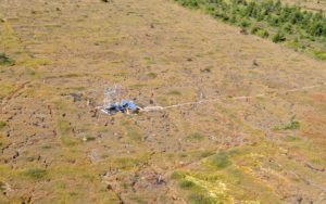
CA-DBB Aerial Photo of the floating platform at CA-DBB
Aerial Photo of the floating platform supporting the Delta Burns Bog (CA-DBB) Eddy covariance and climate measurements. Seen from SE with board walk to the platform. At the flux tower,the University of British Columbia quantifies exchange of carbon-dioxide and methane between the rewetted bog and the atmosphere.
Keywords: Bog,Wetland,Eddy Covariance,Methane,Carbon dioxide,Aerial
Location: British Columbia, Canada
View in Original Size
To download, right-click photo (Mac: control-click) and choose Save Image As
 CA-DBB
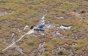
 UBC Micrometeorology Burns Bog Flux Tower – Aerial View
Aerial Photo of the floating platform supporting the Delta Burns Bog (CA-DBB) Eddy covariance and climate measurements. Seen from NNW. At the flux tower,the University of British Columbia quantifies exchange of carbon-dioxide and methane between the rewetted bog and the atmosphere.
Keywords: Bog,Wetland,Eddy Covariance,Methane,Carbon dioxide,Aerial
Location: British Columbia, Canada
View in Original Size
To download, right-click photo (Mac: control-click) and choose Save Image As
 CA-DBB
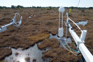
 Burns Bog Flux Tower – Both EC systems
Left: EC system I with CSAT3 ultrasonic anemometer and Li-7500 open path analyzer,Right: EC System II with CSAT3 ultrasonic anemometer,Li-7200 closed path infrared gas analyzer to measure CO2 / H2O fluxes and Li-7700 open path gas analyzer to measure methane (CH4) on Burns Bog Flux Tower (CA-DBB) operated by the University of British Columbia.
Keywords: Bog,Wetland,Eddy Covariance,Methane,Carbon dioxide
Location: British Columbia, Canada
View in Original Size
To download, right-click photo (Mac: control-click) and choose Save Image As
CA-DBB: Delta Burns Bog
- Overview
- Windroses
- Data Citation
- Data Use Log
- Image Gallery
- Remote Sensing Data
- MODIS
- PhenoCam
- GeoNEX
- Publications
- BADM
| AmeriFlux Publications | Add Publication |
| Year | Publication |
|---|---|
| 2021 | Chu, H., Luo, X., Ouyang, Z., Chan, W. S., Dengel, S., Biraud, S. C., Torn, M. S., Metzger, S., Kumar, J., Arain, M. A., Arkebauer, T. J., Baldocchi, D., Bernacchi, C., Billesbach, D., Black, T. A., Blanken, P. D., Bohrer, G., Bracho, R., Brown, S., Brunsell, N. A., Chen, J., Chen, X., Clark, K., Desai, A. R., Duman, T., Durden, D., Fares, S., Forbrich, I., Gamon, J. A., Gough, C. M., Griffis, T., Helbig, M., Hollinger, D., Humphreys, E., Ikawa, H., Iwata, H., Ju, Y., Knowles, J. F., Knox, S. H., Kobayashi, H., Kolb, T., Law, B., Lee, X., Litvak, M., Liu, H., Munger, J. W., Noormets, A., Novick, K., Oberbauer, S. F., Oechel, W., Oikawa, P., Papuga, S. A., Pendall, E., Prajapati, P., Prueger, J., Quinton, W. L., Richardson, A. D., Russell, E. S., Scott, R. L., Starr, G., Staebler, R., Stoy, P. C., Stuart-Haëntjens, E., Sonnentag, O., Sullivan, R. C., Suyker, A., Ueyama, M., Vargas, R., Wood, J. D., Zona, D. (2021) Representativeness Of Eddy-Covariance Flux Footprints For Areas Surrounding Ameriflux Sites, Agricultural And Forest Meteorology, 301-302, 108350. https://doi.org/10.1016/j.agrformet.2021.108350 |
| 2017 | Tortini, R., Coops, N. C., Nesic, Z., Christen, A., Lee, S. C., Hilker, T. (2017) Remote Sensing Of Seasonal Light Use Efficiency In Temperate Bog Ecosystems, Scientific Reports, 7(1), . https://doi.org/https://doi.org/10.1038/s41598-017-08102-x |
| 2019 | McKendry, I. G., Christen, A., Lee, S., Ferrara, M., Strawbridge, K. B., O'Neill, N., Black, A. (2019) Impacts Of An Intense Wildfire Smoke Episode On Surface Radiation, Energy And Carbon Fluxes In Southwestern British Columbia, Canada, Atmospheric Chemistry And Physics, 19(2), 835-846. https://doi.org/https://doi.org/10.5194/acp-19-835-2019 |
| 2019 | D′Acunha, B., Morillas, L., Black, T. A., Christen, A., Johnson, M. S. (2019) Net Ecosystem Carbon Balance Of A Peat Bog Undergoing Restoration: Integrating Co 2 And Ch 4 Fluxes From Eddy Covariance And Aquatic Evasion With Doc Drainage Fluxes, Journal Of Geophysical Research: Biogeosciences, 124(4), 884-901. https://doi.org/https://doi.org/10.1029/2019JG005123 |
| 2017 | Lee, S.-C., Christen, A., Black, T.A., Johnson, M.S., Jassal, R.S., Ketler, R., Nesic, Z., Merkens, M. (2017) Annual greenhouse gas budget for a bog ecosystem undergoing restoration by rewetting, Biogeosciences, 14(11), 2799-2814. https://doi.org/10.5194/bg-14-2799-2017 |
| 2016 | Christen, A., Jassal, R.S., Black, T.A., Grant, N.J., Hawthorne, I, Johnson, M.S., Lee, S.-C., Merkens, M. (2016) Summertime greenhouse gas fluxes from an urban bog undergoing restoration through rewetting, Mires And Peat, (17), 1-24. https://doi.org/10.19189/MaP.2015.OMB.207 |
CA-DBB: Delta Burns Bog
- Overview
- Windroses
- Data Citation
- Data Use Log
- Image Gallery
- Remote Sensing Data
- MODIS
- PhenoCam
- GeoNEX
- Publications
- BADM
BADM for This Site
Access the Biological, Ancillary, Disturbance and Metadata (BADM) information and data for this site.
BADM contain information for many uses, such as characterizing a site’s vegetation and soil, describing disturbance history, and defining instrumentation for flux processing. They complement the flux/met data.
- Download BADM for this site*
- View Site General Info for this site (Overview tab)*
- Use Online Editor to update Site General Info or DOI Authorship
- Update information about submitted data (Variable Information tool)
- More BADM resources
* Online updates are shown on the Overview tab real time. However, downloaded BADM files will not reflect those updates until they have been reviewed for QA/QC.
CA-DBB: Delta Burns Bog
- Overview
- Windroses
- Data Citation
- Data Use Log
- Image Gallery
- Remote Sensing Data
- MODIS
- PhenoCam
- GeoNEX
- Publications
- BADM
Wind Roses
Wind Speed (m/s)
- Wind Speed Scale: Per Site
- Wind Direction Scale (%): Per Site
- Wind Speed Scale: Non-Linear
- Wind Direction Scale (%): AmeriFlux