CA-AF1: Acadia Research Forest
- Overview
- Windroses
- Data Citation
- Data Use Log
- Image Gallery
- Remote Sensing Data
- MODIS
- PhenoCam
- GeoNEX
- Publications
- BADM
Tower_team: | |
PI: | Manuel Helbig manuel.helbig@dal.ca - Dalhousie University |
Technician: | Deirdre Spearns dr691222@dal.ca - Université Laval |
Lat, Long: | 46.0092, -66.3627 |
Elevation(m): | 78 |
Network Affiliations: | AmeriFlux |
Vegetation IGBP: | MF (Mixed Forests: Lands dominated by trees with a percent cover >60% and height exceeding 2 meters. Consists of tree communities with interspersed mixtures or mosaics of the other four forest types. None of the forest types exceeds 60% of landscape.) |
Climate Koeppen: | Dfb (Warm Summer Continental: significant precipitation in all seasons ) |
Mean Annual Temp (°C): | 5.6 |
Mean Annual Precip. (mm): | 1078 |
Flux Species Measured: | CO2, H, H2O |
Years Data Collected: | 2023 - Present |
Years Data Available: | AmeriFlux BASE 2023 - 2024 Data Citation |
Data Use Policy: | AmeriFlux CC-BY-4.0 Policy1 |
Description: | The site is located in the Acadia Research Forest (managed by the Canadian Forest Service). The research forest is representative of the Acadian Forest ... The site is located in the Acadia Research Forest (managed by the Canadian Forest Service). The research forest is representative of the Acadian Forest Region in New Brunswick and Nova Scotia and comprises of mixed forest containing softwood, hardwood, and mixed-wood stands. The forest is managed and features different forest composition depending on management history. See MoreShow Less |
URL: | — |
Research Topics: | Land-atmosphere interactions, extreme events |
Acknowledgment: | — |
- This site’s data can also be used under the more restrictive AmeriFlux Legacy Policy.
The AmeriFlux Legacy Policy must be followed if this site’s data are combined with data from sites that require the AmeriFlux Legacy Policy.


CA-AF1: Acadia Research Forest
- Overview
- Windroses
- Data Citation
- Data Use Log
- Image Gallery
- Remote Sensing Data
- MODIS
- PhenoCam
- GeoNEX
- Publications
- BADM
Use the information below for citation of this site. See the Data Policy page for more details.
DOI(s) for citing CA-AF1 data
Data Use Policy: AmeriFlux CC-BY-4.0 License
This site’s data can also be used under the more restrictive AmeriFlux Legacy Policy.
The AmeriFlux Legacy Policy must be followed if CA-AF1 data are combined with data from sites that require the AmeriFlux Legacy Policy.
- AmeriFlux BASE: https://doi.org/10.17190/AMF/2479623
Citation: Manuel Helbig, Deirdre Spearns (2025), AmeriFlux BASE CA-AF1 Acadia Research Forest, Ver. 2-5, AmeriFlux AMP, (Dataset). https://doi.org/10.17190/AMF/2479623
To cite BADM when downloaded on their own, use the publications below for citing site characterization. When using BADM that are downloaded with AmeriFlux BASE and AmeriFlux FLUXNET products, use the DOI citation for the associated data product.
Publication(s) for citing site characterization
- —
Acknowledgments
- —
Resources
- AmeriFlux Logos & Acknowledgments
CA-AF1: Acadia Research Forest
- Overview
- Windroses
- Data Citation
- Data Use Log
- Image Gallery
- Remote Sensing Data
- MODIS
- PhenoCam
- GeoNEX
- Publications
- BADM

This page displays the list of downloads of data for the site CA-AF1.
Note: Results are the number of downloads to distinct data users. The Download Count column indicates the number of times the data user downloaded the data. The Version column refers to the version of the data product for the site that was downloaded by the data user.
Date | Name | Data Product | Version | Intended Use | Intended Use Description | Download Count |
---|---|---|---|---|---|---|
2025-03-25 | Yoori Cho | AmeriFlux BASE | 2-5 | Research - Other | 2023 Canadian wildifre research | 1 |
2025-03-25 | Jinxia Zhang | AmeriFlux BASE | 2-5 | Other | I hope this email finds you well. I am writing to request access to the AMERIFLUX dataset. My purpose is to use this data to validate the accuracy of the evaporation data from the GLEAM4.2 product. This validation will help assess the reliability of GLEAM4.2 in estimating evaporation across different regions. | 1 |
2025-03-25 | Peng Zhang | AmeriFlux BASE | 2-5 | Other | Surface albedo studies | 1 |
2025-03-23 | babak safa | AmeriFlux BASE | 2-5 | Research - Multi-site synthesis | Research | 1 |
2025-03-18 | Jingyi Bu | AmeriFlux BASE | 2-5 | Research - Remote sensing | Upscaling of eddy covariance measurements from point to continental scale. | 2 |
2025-03-13 | Sophie Hoffman | AmeriFlux BASE | 2-5 | Research - Multi-site synthesis | GPP modeling | 1 |
2025-03-13 | Heine Nygard Riise | AmeriFlux BASE | 2-5 | Research - Remote sensing | Remote sensing of albedo for PV site selection. Validation of empirical model for Sentinel-2 MSI bands | 1 |
2025-03-11 | Yanzu Wu | AmeriFlux BASE | 2-5 | Other | 遥感 | 1 |
2025-03-11 | Xinming Zhu | AmeriFlux BASE | 2-5 | Research - Remote sensing | Inversion research of surface temperature under cloud and sky conditions | 3 |
2025-03-11 | Kai Z | AmeriFlux BASE | 2-5 | Research - Remote sensing | LST | 8 |
2025-03-05 | Sean Matus | AmeriFlux BASE | 2-5 | Research - Other | Estimating wet bulb globe temperature from meteorological data | 1 |
2025-03-04 | Habtamu Tamiru | AmeriFlux BASE | 2-5 | Research - Multi-site synthesis | I want to use these ET estimates to evaluate the ET estimated in my current study using Budyko functional equations. | 1 |
2025-03-03 | Hector Nieto Solana | AmeriFlux BASE | 2-5 | Research - Remote sensing | Validation of Thermal-based energy balance TSEB model using Earth Observation imagery | 1 |
2025-03-02 | Jiatong Gu | AmeriFlux BASE | 2-5 | Other | scientific research | 1 |
2025-02-28 | Taylor Smith | AmeriFlux BASE | 2-5 | Research - Multi-site synthesis | Exploratory Research on flux changes | 1 |
2025-02-27 | Mengtao Ci | AmeriFlux BASE | 2-5 | Research - Remote sensing | I plan to carry out a study on global evapotranspiration with the main objective of global evapotranspiration data fusion from 1982 to 2023 using latent heat flux data in combination with other remote sensing and meteorological data. As an important component of the global water cycle and climate system, evapotranspiration directly affects the distribution and variability of regional and global water resources. Therefore, accurate assessment and understanding of spatial and temporal changes in ET is important for climate change research, water resources management and ecosystem monitoring. | 1 |
2025-02-25 | Lingcheng Li | AmeriFlux BASE | 2-5 | Research - Multi-site synthesis | compare with model simulations | 1 |
2025-02-24 | Jing Peiqing | AmeriFlux BASE | 2-5 | Other | Assessing terrestrial ecosystem resilience based on remotely sensed data, wanting to use site data as ground validation | 2 |
2025-02-24 | Feng Wang | AmeriFlux BASE | 2-5 | Research - Multi-site synthesis | The data will be used for a study focusing on tree growth monitoring across the US. | 1 |
2025-02-21 | Jeffrey Wood | AmeriFlux BASE | 2-5 | Research - Multi-site synthesis | collecting to preserve for possible future use | 1 |
2025-02-19 | Hirofumi Hashimoto | AmeriFlux BASE | 2-5 | Research - Remote sensing | Validation for ecosystem model based on remote sensing | 1 |
2025-02-18 | Han SangHoon | AmeriFlux BASE | 2-5 | Research - Remote sensing | AmeriFlux Network: | 1 |
2025-02-18 | Shiyuan Wang | AmeriFlux BASE | 2-5 | Other | STUDY | 1 |
2025-02-18 | Ziyu Lin | AmeriFlux BASE | 2-5 | Research - Land model/Earth system model | GPP modelling | 1 |
2025-02-14 | du peng | AmeriFlux BASE | 2-5 | Research - Remote sensing | https://ameriflux.lbl.gov/data/download-data/ | 10 |
2025-02-13 | Isla Simpson | AmeriFlux BASE | 2-5 | Research - Land model/Earth system model | Comparing water availability in ESMs with ameriflux data. | 1 |
2025-02-13 | Kesondra Key | AmeriFlux BASE | 2-5 | Research - Other | Data back up for safe keeping | 1 |
2025-02-13 | Kim Novick | AmeriFlux BASE | 2-5 | Research - Multi-site synthesis | Local data backup, just in case. | 1 |
2025-02-08 | (unknown user_id) | AmeriFlux BASE | 2-5 | Other | caculate ET | 1 |
2025-02-05 | MA MENG IN | AmeriFlux BASE | 2-5 | Research - Remote sensing | for school competition use | 1 |
2025-02-01 | huang duan | AmeriFlux BASE | 2-5 | Research - Multi-site synthesis | Exploring the spatiotemporal changes and remote sensing modeling of global carbon water flux using multi site data. | 1 |
2025-01-28 | Elijah Walker | AmeriFlux BASE | 1-5 | Research - Land model/Earth system model | Analyzing GHG gases spatio-temporally to understand its impacts on ecosystem | 1 |
2025-01-20 | Mohamed Hedi Rhouma | AmeriFlux BASE | 1-5 | Research - Remote sensing | to estimate eta | 1 |
2025-01-10 | xiong wei | AmeriFlux BASE | 1-5 | Education (Teacher or Student) | 完成学业 | 3 |
2025-01-08 | Jingfeng Xiao | AmeriFlux BASE | 1-5 | Research - Remote sensing | evaluate remotely sensed indices. | 1 |
2025-01-06 | Brandon Norton Benton | AmeriFlux BASE | 1-5 | Research - Land model/Earth system model | Used in wind model training and validation. Model is used to generate high-resolution wind data for wind resource adequacy analysis. | 1 |
2025-01-04 | Cheng Gao | AmeriFlux BASE | 1-5 | Research - Land model/Earth system model | For model validation. | 1 |
2024-12-26 | Xinqu Wu | AmeriFlux BASE | 1-5 | Research - Multi-site synthesis | other | 3 |
2024-12-25 | Pushpendra Raghav | AmeriFlux BASE | 1-5 | Research - Remote sensing | validate the model of ET estimation [amerifluxr download] | 1 |
2024-12-24 | Aolin Jia | AmeriFlux BASE | 1-5 | Research - Remote sensing | valdiating GOES-R all-sky land surface temperature product | 1 |
2024-12-17 | Heine Nygard Riise | AmeriFlux BASE | 1-5 | Research - Remote sensing | Estimate albedo from Sentinel-2 mission | 1 |
2024-12-12 | Pei Wang | AmeriFlux BASE | 1-5 | Research - Multi-site synthesis | Is the two-source model for evapotranspiration we developed reliable? | 1 |
2024-12-10 | valerie Liu | AmeriFlux BASE | 1-5 | Research - Remote sensing | validation of latent heat flux | 1 |
2024-12-10 | Getachew Mulualem | AmeriFlux BASE | 1-5 | Research - Other | Research | 5 |
2024-12-05 | Miguel Barrios | AmeriFlux BASE | 1-5 | Research - Remote sensing | Quality assessment of models based on remote sensing data | 2 |
Date | Name | Data Product | Vers. | Intended Use | Intended Use Description | Download Count |
---|---|---|---|---|---|---|
2025-03-25 | Yoori Cho | AmeriFlux BASE | 2-5 | Research - Other | 2023 Canadian wildifre research | 1 |
2025-03-25 | Jinxia Zhang | AmeriFlux BASE | 2-5 | Other | I hope this email finds you well. I am writing to request access to the AMERIFLUX dataset. My purpose is to use this data to validate the accuracy of the evaporation data from the GLEAM4.2 product. This validation will help assess the reliability of GLEAM4.2 in estimating evaporation across different regions. | 1 |
2025-03-25 | Peng Zhang | AmeriFlux BASE | 2-5 | Other | Surface albedo studies | 1 |
2025-03-23 | babak safa | AmeriFlux BASE | 2-5 | Research - Multi-site synthesis | Research | 1 |
2025-03-18 | Jingyi Bu | AmeriFlux BASE | 2-5 | Research - Remote sensing | Upscaling of eddy covariance measurements from point to continental scale. | 2 |
2025-03-13 | Sophie Hoffman | AmeriFlux BASE | 2-5 | Research - Multi-site synthesis | GPP modeling | 1 |
2025-03-13 | Heine Nygard Riise | AmeriFlux BASE | 2-5 | Research - Remote sensing | Remote sensing of albedo for PV site selection. Validation of empirical model for Sentinel-2 MSI bands | 1 |
2025-03-11 | Yanzu Wu | AmeriFlux BASE | 2-5 | Other | 遥感 | 1 |
2025-03-11 | Xinming Zhu | AmeriFlux BASE | 2-5 | Research - Remote sensing | Inversion research of surface temperature under cloud and sky conditions | 3 |
2025-03-11 | Kai Z | AmeriFlux BASE | 2-5 | Research - Remote sensing | LST | 8 |
Showing 1 to 10 of 45 results
Not Found
Uh Oh. Something is missing. Try double checking the URL and try again.
CA-AF1: Acadia Research Forest
- Overview
- Windroses
- Data Citation
- Data Use Log
- Image Gallery
- Remote Sensing Data
- MODIS
- PhenoCam
- GeoNEX
- Publications
- BADM
AmeriFlux Images | Add Image |
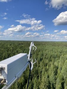
View from the Acadia Research Forest flux tower
Keywords: Acadian forest
Location: New Brunswick, Canada
View in Original Size
To download, right-click photo (Mac: control-click) and choose Save Image As
CA-AF1: Acadia Research Forest
- Overview
- Windroses
- Data Citation
- Data Use Log
- Image Gallery
- Remote Sensing Data
- MODIS
- PhenoCam
- GeoNEX
- Publications
- BADM
MODIS NDVI
The time series shows the 16-day Normalized Difference Vegetation Index (NDVI) average from the MOD13Q1 data product.
Use the slider below the time series to zoom in and out.
To view / download these data and other MOD13Q1 products for this site, visit MODIS/Terra Vegetation Indices.
For other related products, visit MODIS/VIIRS Fixed Sites Subsets Tool.
Citation:
ORNL DAAC. 2018. Terrestrial Ecology Subsetting & Visualization Services (TESViS) Fixed Sites Subsets. ORNL DAAC, Oak Ridge, Tennessee, USA. https://doi.org/10.3334/ORNLDAAC/1567
MODIS NDVI subsetted data is not yet available for this site.
For a complete list of AmeriFlux sites, visit ORNL DAAC's MODIS/VIIRS Fixed Sites Subsets Tool.
PhenoCam Images and Derived Time Series Data
PhenoCams are high-resolution digital cameras that take repeated images of studied ecosystems and provide quantitative information about the canopy phenology. The PhenoCam Network coordinates the camera installation and data reporting/analyses across sites in the Americas, providing automated, near-surface remote sensing of canopy phenology across a range of ecosystems and climate zones. Use of PhenoCam images / data should follow the PhenoCam Data Use Policy .
No PhenoCam data for this siteGeoNEX Data Products
GeoNEX led by NASA Earth eXchange (NEX) is a collaborative effort for generating Earth monitoring products from the new generation of geostationary satellite sensors. GeoNEX has produced a suite of geostationary data products including surface reflectance, land surface temperature, surface solar radiation, and many others.
The GeoNEX Common Grid locates GeoNEX data in the geographic (latitude/longitude) projection. Pixels (grid cells) are created at regular 0.005°, 0.01°, and 0.02° resolutions.
GeoNEX pixels below cover the area 0.06° x 0.06° around and including site CA-AF1, 46.0092, -66.3627.
Click a square in the grid at left to display its data below.
Coordinates for selected GeoNEX Pixel
Lat: 46.0300 Long: -66.4000
CA-AF1
Graph controls:
- Zoom: click-drag
- Pan: shift-click-drag
- Restore zoom level: double-click
- Use the slider below the time series to zoom in and out.
All download requests will be logged.
NDVI: Normalized Difference Vegetation Index
Resolution: 0.01° x 0.01° & 10 minutes
Coordinates for pixel: Lat: 46.0300 Long: -66.4000
NIRv Near-Infrared Reflectance of vegetation
Resolution: 0.01° x 0.01° & 10 minutes
Coordinates for pixel: Lat: 46.0300 Long: -66.4000
DSR: Surface downward shortwave radiation
Resolution: 0.01° x 0.01° & Hourly
Coordinates for pixel: Lat: 46.0300 Long: -66.4000
LST: Land Surface Temperature
Resolution: 0.02° x 0.02° & Hourly
Coordinates for pixel: Lat: 46.0200 Long: -66.4000
Citation
This material can be used without obtaining permission from NASA. NASA should be acknowledged as the source of this material.
Subset Data Citation:
- Hashimoto, H., Wang, W., Park, T., Khajehei, S., Ichii, K., Michaelis, A.R., Guzman, A., Nemani, R.R., Torn, M., Yi, K., Brosnan, I.G. (in preparation). Subsets of geostationary satellite data over international observing network sites for studying the diurnal dynamics of energy, carbon, and water cycles.
Relevant Science Publication Citation:
GeoNEX Surface Reflectance for Vegetation Indices (NDVI & NIRv)- Wang, W., Wang, Y., Lyapustin, A., Hashimoto, H., Park, T., Michaelis, A., & Nemani, R. (2022). A novel atmospheric correction algorithm to exploit the diurnal variability in hypertemporal geostationary observations. Remote Sensing, 14(4), 964.
- Li, R., Wang, D., Wang, W., & Nemani, R. (2023). A GeoNEX-based high-spatiotemporal-resolution product of land surface downward shortwave radiation and photosynthetically active radiation. Earth System Science Data, 15(3), 1419-1436.
- Jia, A., Liang, S., & Wang, D. (2022). Generating a 2-km, all-sky, hourly land surface temperature product from Advanced Baseline Imager data. Remote Sensing of Environment, 278, 113105.
CA-AF1: Acadia Research Forest
- Overview
- Windroses
- Data Citation
- Data Use Log
- Image Gallery
- Remote Sensing Data
- MODIS
- PhenoCam
- GeoNEX
- Publications
- BADM
AmeriFlux Publications | Add Publication |
CA-AF1: Acadia Research Forest
- Overview
- Windroses
- Data Citation
- Data Use Log
- Image Gallery
- Remote Sensing Data
- MODIS
- PhenoCam
- GeoNEX
- Publications
- BADM
BADM for This Site
Access the Biological, Ancillary, Disturbance and Metadata (BADM) information and data for this site.
BADM contain information for many uses, such as characterizing a site’s vegetation and soil, describing disturbance history, and defining instrumentation for flux processing. They complement the flux/met data.
- Download BADM for this site*
- View Site General Info for this site (Overview tab)*
- Use Online Editor to update Site General Info or DOI Authorship
- Update information about submitted data (Variable Information tool)
- More BADM resources
* Online updates are shown on the Overview tab real time. However, downloaded BADM files will not reflect those updates until they have been reviewed for QA/QC.
CA-AF1: Acadia Research Forest
- Overview
- Windroses
- Data Citation
- Data Use Log
- Image Gallery
- Remote Sensing Data
- MODIS
- PhenoCam
- GeoNEX
- Publications
- BADM