
US-RFW: RockyFlats - West site
- Overview
- Windroses
- Data Citation
- Data Use Log
- Image Gallery
- Related Data
- MODIS
- PhenoCam
- Publications
- BADM
| Tower_team: | |
| AncContact: | Thomas S. Thienelt thomas.thienelt@geo.uni-halle.de - Martin-Luther-University |
| PI: | Dean Anderson deander@usgs.gov - U.S. Geological Survey |
| Lat, Long: | 39.8751, -105.2184 |
| Elevation(m): | 1864 |
| Network Affiliations: | AmeriFlux |
| Vegetation IGBP: | GRA (Grasslands: Lands with herbaceous types of cover. Tree and shrub cover is less than 10%. Permanent wetlands lands with a permanent mixture of water and herbaceous or woody vegetation. The vegetation can be present in either salt, brackish, or fresh water.) |
| Climate Koeppen: | Bsk (Steppe: warm winter) |
| Mean Annual Temp (°C): | 10.2 |
| Mean Annual Precip. (mm): | 468 |
| Flux Species Measured: | CO2, H2O, H |
| Years Data Collected: | 2010 - 2017 |
| Years Data Available: | No data available |
| Data Use Policy: | AmeriFlux Legacy Policy |
| Description: | |
| URL: | — |
| Research Topics: | Impact of water availability on long term NEE of CO2. |
| Acknowledgment: | — |
Copyright preference: Open use
US-RFW: RockyFlats - West site
- Overview
- Windroses
- Data Citation
- Data Use Log
- Image Gallery
- Related Data
- MODIS
- PhenoCam
- Publications
- BADM
Use the information below for citation of this site. See the Data Policy page for more details.
DOI(s) for citing US-RFW data
Data Use Policy: AmeriFlux Legacy Policy
- No DOIs available for US-RFW
To cite BADM downloaded as a BIF file, use the publications listed below.
Publication(s) for citing site characterization
- —
Acknowledgments
- —
Resources
- AmeriFlux Logos & Acknowledgments
US-RFW: RockyFlats - West site
- Overview
- Windroses
- Data Citation
- Data Use Log
- Image Gallery
- Related Data
- MODIS
- PhenoCam
- Publications
- BADM

This page displays the list of downloads of data for the site {{siteId}}.
Note: Results are the number of downloads to distinct data users. The Download Count column indicates the number of times the data user downloaded the data. The Version column refers to the version of the data product for the site that was downloaded by the data user.
| Date | Name | Data Product | Vers. | Intended Use | Intended Use Description | Download Count |
|---|---|---|---|---|---|---|
| {{dlObject.timeStamp}} | {{dlObject.displayName}} | {{displayProduct(dlObject.dataProduct)}} | {{dlObject.version}} | {{dlObject.intendedUse}} | {{dlObject.comment}} | {{dlObject.downloadCounter}} |
Showing {{startItem + 1}} to {{(startItem + items) > filtered.length ? filtered.length : (startItem + items)}} of {{filtered.length}} results
Showing 0 to 0 of 0 results
Not Found
Uh Oh. Something is missing. Try double checking the URL and try again.
US-RFW: RockyFlats - West site
- Overview
- Windroses
- Data Citation
- Data Use Log
- Image Gallery
- Related Data
- MODIS
- PhenoCam
- Publications
- BADM
| AmeriFlux Images | Add Image |
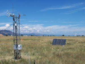
Rocky Flats West Station
Campbell CSAT3, Li7200 station. Rocky Flats National Wildlife Refuge Near Arvada Colorado. Northward view.
Location: Colorado, United States
View in Original Size
To download, right-click photo (Mac: control-click) and choose Save Image As
US-RFW: RockyFlats - West site
- Overview
- Windroses
- Data Citation
- Data Use Log
- Image Gallery
- Related Data
- MODIS
- PhenoCam
- Publications
- BADM
| AmeriFlux Publications | Add Publication |
US-RFW: RockyFlats - West site
- Overview
- Windroses
- Data Citation
- Data Use Log
- Image Gallery
- Related Data
- MODIS
- PhenoCam
- Publications
- BADM
BADM for This Site
Access the Biological, Ancillary, Disturbance and Metadata (BADM) information and data for this site.
BADM contain information for many uses, such as characterizing a site’s vegetation and soil, describing disturbance history, and defining instrumentation for flux processing. They complement the flux/met data.
- Download BADM for this site*
- View Site General Info for this site (Overview tab)*
- Use Online Editor to update Site General Info or DOI Authorship
- Update information about submitted data (Variable Information tool)
- More BADM resources
* Online updates are shown on the Overview tab real time. However, downloaded BADM files will not reflect those updates until they have been reviewed for QA/QC.
US-RFW: RockyFlats - West site
- Overview
- Windroses
- Data Citation
- Data Use Log
- Image Gallery
- Related Data
- MODIS
- PhenoCam
- Publications
- BADM